

L'Epinay Windmill
No reviews yet
Have you flown here? Share your experience with other pilots.
+ Write the first reviewHistory
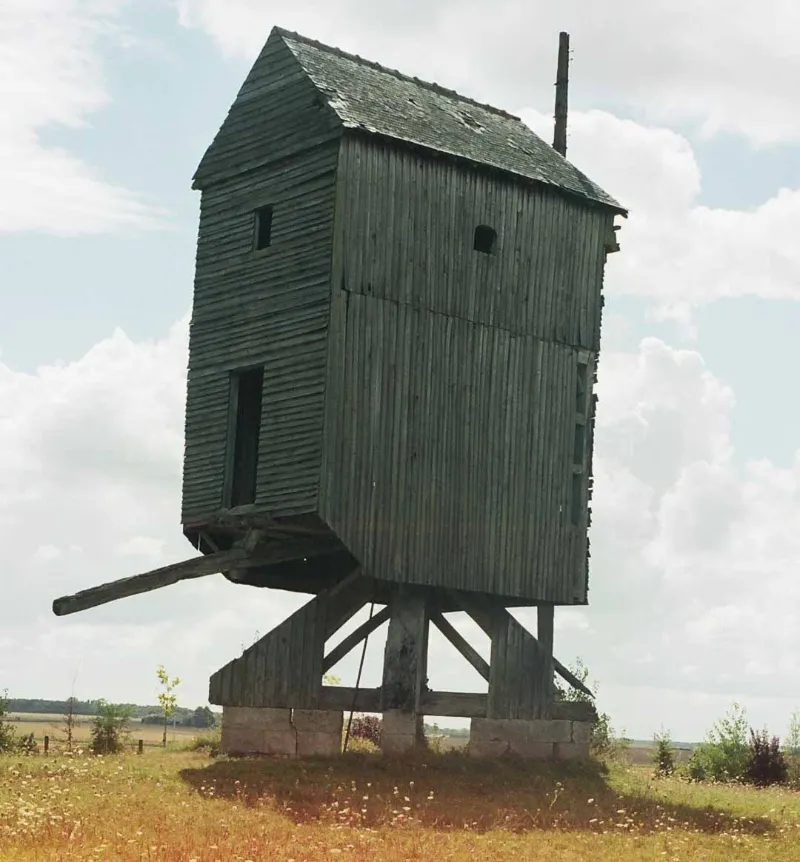
Le moulin est attesté sur le cadastre de 1834. Après 1850, il fut équipé du système Berton permettant au meunier de régler la surface des ailes constituées de lattes de bois depuis l'intérieur du moulin. Actuellement, le mécanisme du moulin a presque totalement disparu et seule subsiste une des deux verges des ailes, désaxée et plantée au sol. £Il s'agit d'un moulin-pivot sur dés de pierre, à deux niveaux. L'escalier intérieur a disparu. L'arbre est encore muni de son rouet, dernier vestige du mécanisme.
Map and restricted areas
Open in the main mapRestricted zones
Nearby aerodromes
Open aerodromes within 25 km of the spot, heliports included, with their distance and direction from the spot. Near an aerodrome, drone flying is prohibited or height-limited: check the UAS zones map.
| Aerodrome | Type | Distance | Elevation |
|---|---|---|---|
| Orléans – Saint-Denis-de-l'Hôtel Airport | Aerodrome | 13 km SE | 121 m |
| La Source Heliport | Heliport | 19 km SW | 108 m |
| Orléans-Bricy (BA 123) Air Base | Airport | 22 km W | 126 m |
| Pithiviers Airfield | Aerodrome | 22 km NE | 117 m |
Aviation weather (METAR and TAF)
LFOZ – Orléans – Saint-Denis-de-l'Hôtel Airport MVFR
METAR
METAR LFOZ 171400Z AUTO 21019KT 9999 BKN030 15/11 Q0994
- Wind
- 210°, 35 km/h
- Visibility
- 10 km or more
- Clouds
- Broken (5-7/8) at 3,000 ft (910 m)
- Temperature
- 15 °C, dew point 11 °C
- QNH
- 994 hPa
- Flight category
- MVFR: ceiling 1,000–3,000 ft or visibility 3–5 mi
TAF
Weather and Kp index
Sunrise and sunset
| Day | Dawn | Sunrise | Golden hour | Sunset | Dusk | Day length |
|---|---|---|---|---|---|---|
| Tue 17 Nov | 07:27 | 08:01 | 08:01–08:50 · 16:24–17:12 | 17:12 | 17:46 | 9 h 11 |
| Wed 18 Nov | 07:28 | 08:03 | 08:03–08:51 · 16:22–17:11 | 17:11 | 17:45 | 9 h 08 |
| Thu 19 Nov | 07:30 | 08:04 | 08:04–08:53 · 16:21–17:10 | 17:10 | 17:44 | 9 h 06 |
| Fri 20 Nov | 07:31 | 08:05 | 08:05–08:55 · 16:20–17:09 | 17:09 | 17:44 | 9 h 03 |
| Sat 21 Nov | 07:33 | 08:07 | 08:07–08:57 · 16:19–17:08 | 17:08 | 17:43 | 9 h 01 |
| Sun 22 Nov | 07:34 | 08:08 | 08:08–08:58 · 16:18–17:07 | 17:07 | 17:42 | 8 h 59 |
| Mon 23 Nov | 07:35 | 08:10 | 08:10–09:00 · 16:17–17:07 | 17:07 | 17:41 | 8 h 56 |

Reviews (0)
Log in to review this spot. Log in · Create a free account
No reviews yet. Share yours!