

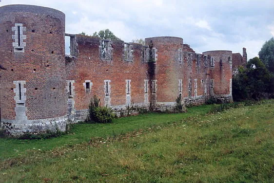
Remains of Hallier Castle
No reviews yet
Have you flown here? Share your experience with other pilots.
+ Write the first reviewHistory
Le château se présente comme un quadrilatère dont les murs de courtine sont cantonnés de dix grosses tours circulaires. L'appareil est de brique à chaînages de pierres apparentes. A l'ouest se trouve l'entrée avec un pont dormant qui semble remonter au 17e siècle, refait en 1939. A gauche de cette entrée s'ouvre une galerie couverte, du milieu du 16e siècle. A la suite, s'ouvre une autre galerie couverte qui prolonge celle de l'ouest et longe la courtine nord. A droite de cette galerie s'ouvrent d'anciennes salles basses, édifiées au 16e siècle sur des infrastructures peut-être légèrement antérieures. A la courtine est, s'adossent d'anciennes écuries, à double nef. La tour centrale de la façade Est a été démolie. Un ancien four de poteries locales se trouve à la suite. Il est possible qu'il ait primitivement servi de chapelle pour le château. A la courtine sud s'adossent quelques bâtiments à usage agricole et l'habitation des propriétaires. En avancée sur cette façade et située dans la cour, une grange semble dater du milieu du 17e siècle. Le château est entouré de douves creusées à pleine terre, transformées en parterres fleuris.
Map and restricted areas
Open in the main mapRestricted zones
| Zone | Category | Limits | Conditions |
|---|---|---|---|
| Zrt Dsv Oz N1 | ZRT | FL 055 / FL 085 | SUP AIP 221/26 · Du lundi 19 octobre au jeudi 31 décembre 2026 |
Nearby aerodromes
Open aerodromes within 25 km of the spot, heliports included, with their distance and direction from the spot. Near an aerodrome, drone flying is prohibited or height-limited: check the UAS zones map.
| Aerodrome | Type | Distance | Elevation |
|---|---|---|---|
| Orléans – Saint-Denis-de-l'Hôtel Airport | Aerodrome | 17 km SW | 121 m |
| Pithiviers Airfield | Aerodrome | 18 km NW | 117 m |
Aviation weather (METAR and TAF)
LFOZ – Orléans – Saint-Denis-de-l'Hôtel Airport MVFR
METAR
METAR LFOZ 171400Z AUTO 21019KT 9999 BKN030 15/11 Q0994
- Wind
- 210°, 35 km/h
- Visibility
- 10 km or more
- Clouds
- Broken (5-7/8) at 3,000 ft (910 m)
- Temperature
- 15 °C, dew point 11 °C
- QNH
- 994 hPa
- Flight category
- MVFR: ceiling 1,000–3,000 ft or visibility 3–5 mi
TAF
Weather and Kp index
Sunrise and sunset
| Day | Dawn | Sunrise | Golden hour | Sunset | Dusk | Day length |
|---|---|---|---|---|---|---|
| Tue 17 Nov | 07:26 | 08:00 | 08:00–08:49 · 16:23–17:11 | 17:11 | 17:45 | 9 h 11 |
| Wed 18 Nov | 07:28 | 08:02 | 08:02–08:51 · 16:21–17:10 | 17:10 | 17:44 | 9 h 08 |
| Thu 19 Nov | 07:29 | 08:03 | 08:03–08:52 · 16:20–17:09 | 17:09 | 17:43 | 9 h 06 |
| Fri 20 Nov | 07:30 | 08:05 | 08:05–08:54 · 16:19–17:08 | 17:08 | 17:42 | 9 h 03 |
| Sat 21 Nov | 07:32 | 08:06 | 08:06–08:56 · 16:18–17:07 | 17:07 | 17:42 | 9 h 01 |
| Sun 22 Nov | 07:33 | 08:07 | 08:07–08:57 · 16:16–17:06 | 17:06 | 17:41 | 8 h 58 |
| Mon 23 Nov | 07:34 | 08:09 | 08:09–08:59 · 16:15–17:05 | 17:05 | 17:40 | 8 h 56 |
Reviews (0)
Log in to review this spot. Log in · Create a free account
No reviews yet. Share yours!