

Dompierre Castle
No reviews yet
Have you flown here? Share your experience with other pilots.
+ Write the first reviewHistory
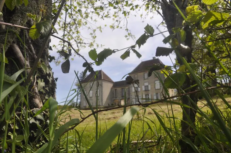
Le site de Dompierre était une seigneurie avant la construction de l'actuel château. En 1441, Percheron Poute, écuyer, seigneur du château, obtint du seigneur de Magnac, la permission de fortifier l'édifice. L'ensemble se compose de murailles fortifiées et du château proprement dit. Ce château du 17e siècle, construit sur une ancienne maison forte dont il reste les murailles fortifiées du 15e siècle, a connu plusieurs agrandissements aux 18e et 19e siècles. Trois corps de bâtiment en équerre sont fermés par un mur. La muraille conserve la souche d'une tourelle disparue, sans doute à rôle défensif. L'aile sud est d'ordonnance classique. Les deux pavillons 18e se détachent du corps de logis 19e. Le pavillon nord-ouest, avec sa toiture à quatre versants et ses fenêtres en arc bombé, est caractéristique du 18e siècle. Le corps de logis du 19e siècle réunit les deux pavillons. Sa galerie à colonnes le fait communiquer avec la cour intérieure.
Map and restricted areas
Open in the main mapRestricted zones
Nearby aerodromes
Open aerodromes within 25 km of the spot, heliports included, with their distance and direction from the spot. Near an aerodrome, drone flying is prohibited or height-limited: check the UAS zones map.
| Aerodrome | Type | Distance | Elevation |
|---|---|---|---|
| Base ULM Le Pommier | Aerodrome | 14 km E | 347 m |
Aviation weather (METAR and TAF)
LFBL – Limoges Airport VFR
METAR
METAR LFBL 171400Z AUTO 22011KT 190V250 9999 SCT031 BKN037 15/10 Q1001 TEMPO 24015G25KT 4000 SHRA BKN010 BKN015TCU
- Wind
- 220°, 20 km/h
- Visibility
- 10 km or more
- Clouds
- Scattered (3-4/8) at 3,100 ft (940 m) ; Broken (5-7/8) at 3,700 ft (1130 m)
- Temperature
- 15 °C, dew point 10 °C
- QNH
- 1001 hPa
- Flight category
- VFR: ceiling > 3,000 ft and visibility > 5 mi
TAF
TAF LFBL 171100Z 1712/1812 24010KT 9999 BKN020 TEMPO 1712/1812 24015G25KT 4000 SHRA BKN010 BKN015TCU PROB30 TEMPO 1720/1724 24020G35KT 2000 TSRA BKN005 BKN015CB PROB30 TEMPO 1808/1812 26015G40KT 1500 TSRA BKN005 BKN010CB
| Period (local time) | Change | Wind | Visibility | Weather | Clouds |
|---|---|---|---|---|---|
| 17/11 13:00 → 18/11 13:00 | Initial conditions | 240°, 19 km/h | 10 km or more | Broken (5-7/8) at 2,000 ft (610 m) | |
| 17/11 13:00 → 18/11 13:00 | Temporarily | 240°, 28 km/h, gusts 46 km/h | 4.0 km | Showers of rain | Broken (5-7/8) at 1,000 ft (300 m) ; Broken (5-7/8) at 1,500 ft (460 m) (towering cumulus) |
| 17/11 21:00 → 18/11 01:00 | Temporarily, probability 30% | 240°, 37 km/h, gusts 65 km/h | 2.0 km | Thunderstorm rain | Broken (5-7/8) at 500 ft (150 m) ; Broken (5-7/8) at 1,500 ft (460 m) (cumulonimbus) |
| 18/11 09:00 → 18/11 13:00 | Temporarily, probability 30% | 260°, 28 km/h, gusts 74 km/h | 1.5 km | Thunderstorm rain | Broken (5-7/8) at 500 ft (150 m) ; Broken (5-7/8) at 1,000 ft (300 m) (cumulonimbus) |
Weather and Kp index
Sunrise and sunset
| Day | Dawn | Sunrise | Golden hour | Sunset | Dusk | Day length |
|---|---|---|---|---|---|---|
| Tue 17 Nov | 07:26 | 07:59 | 07:59–08:45 · 16:35–17:21 | 17:21 | 17:54 | 9 h 22 |
| Wed 18 Nov | 07:27 | 08:00 | 08:00–08:47 · 16:33–17:20 | 17:20 | 17:53 | 9 h 19 |
| Thu 19 Nov | 07:29 | 08:02 | 08:02–08:48 · 16:32–17:19 | 17:19 | 17:52 | 9 h 17 |
| Fri 20 Nov | 07:30 | 08:03 | 08:03–08:50 · 16:31–17:18 | 17:18 | 17:51 | 9 h 15 |
| Sat 21 Nov | 07:31 | 08:04 | 08:04–08:51 · 16:30–17:17 | 17:17 | 17:50 | 9 h 13 |
| Sun 22 Nov | 07:33 | 08:06 | 08:06–08:53 · 16:29–17:16 | 17:16 | 17:50 | 9 h 10 |
| Mon 23 Nov | 07:34 | 08:07 | 08:07–08:55 · 16:28–17:16 | 17:16 | 17:49 | 9 h 08 |
Reviews (0)
Log in to review this spot. Log in · Create a free account
No reviews yet. Share yours!