

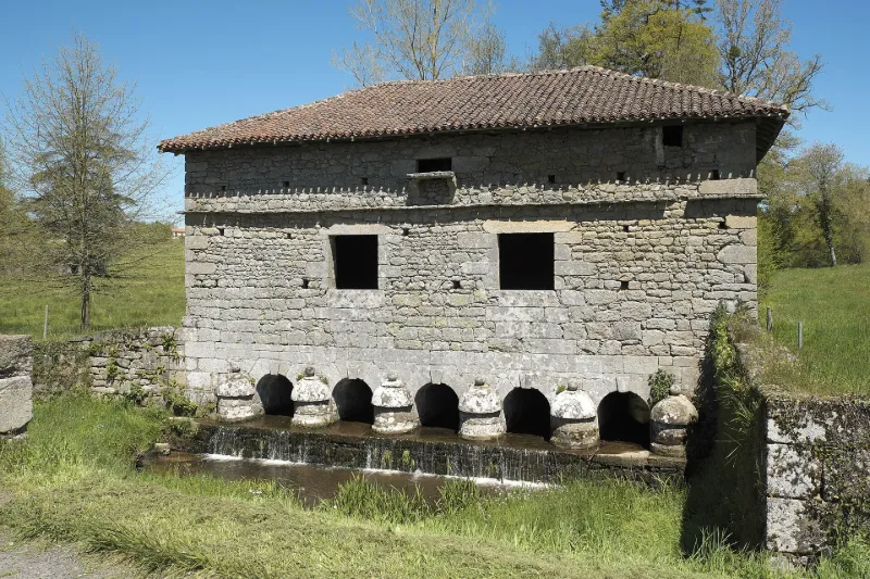
Bridge surmounted by a dovecote
No reviews yet
Have you flown here? Share your experience with other pilots.
+ Write the first reviewHistory
Ce colombier fut probablement construit par Jean de Londeix, sieur de la Puytignon, qui acquit le manoir de Veyrac et ses terres en 1626. Il y avait deux colombiers de la sorte servant de ponts couverts et symétriques par rapport à l'avenue menant au manoir de Veyrac. L'autre colombier et le manoir ont été détruits. Ce colombier, dont les cellules de bois ont disparu, consiste en un bâtiment rectangulaire au toit presque plat, à quatre versants couverts de tuiles courbes. Il est construit sur l'eau par l'intermédiaire de cinq petits archés en plein cintre avec clé en saillie reposant sur un radier incliné. De chaque côté, les piles sont flanquées de poivrières, surmontées d'une boule. Au-dessus, deux ouvertures éclairent l'intérieur. Elles sont surmontées d'un bandeau de pierres clivées. Corniche saillante destinée à empêcher les rongeurs d'y entrer. La seule issue ouverte en permanence à l'époque était la piste d'envol, située au-dessus de la moulure.
Map and restricted areas
Open in the main mapRestricted zones
| Zone | Category | Limits | Conditions |
|---|---|---|---|
| Ctr Limoges Bellegarde |
Zone de contrôle civile | 50 m above ground level → 305 m above ground level | Flights above 50 metres are forbidden without the prior agreement of air traffic control |
Nearby aerodromes
Open aerodromes within 25 km of the spot, heliports included, with their distance and direction from the spot. Near an aerodrome, drone flying is prohibited or height-limited: check the UAS zones map.
| Aerodrome | Type | Distance | Elevation |
|---|---|---|---|
| Limoges Airport | Airport | 6.5 km SE | 396 m |
| Centre Hospitalier Heliport | Heliport | 13 km SE | 274 m |
| Aérodrome de Saint-Junien | Aerodrome | 15 km W | 275 m |
Aviation weather (METAR and TAF)
LFBL – Limoges Airport VFR
METAR
METAR LFBL 171330Z AUTO 21012KT 9999 SCT032 SCT041 OVC180 15/10 Q1001 TEMPO 24015G25KT 4000 SHRA BKN010 BKN015TCU
- Wind
- 210°, 22 km/h
- Visibility
- 10 km or more
- Clouds
- Scattered (3-4/8) at 3,200 ft (980 m) ; Scattered (3-4/8) at 4,100 ft (1250 m) ; Overcast (8/8) at 18,000 ft (5490 m)
- Temperature
- 15 °C, dew point 10 °C
- QNH
- 1001 hPa
- Flight category
- VFR: ceiling > 3,000 ft and visibility > 5 mi
TAF
TAF LFBL 171100Z 1712/1812 24010KT 9999 BKN020 TEMPO 1712/1812 24015G25KT 4000 SHRA BKN010 BKN015TCU PROB30 TEMPO 1720/1724 24020G35KT 2000 TSRA BKN005 BKN015CB PROB30 TEMPO 1808/1812 26015G40KT 1500 TSRA BKN005 BKN010CB
| Period (local time) | Change | Wind | Visibility | Weather | Clouds |
|---|---|---|---|---|---|
| 17/11 13:00 → 18/11 13:00 | Initial conditions | 240°, 19 km/h | 10 km or more | Broken (5-7/8) at 2,000 ft (610 m) | |
| 17/11 13:00 → 18/11 13:00 | Temporarily | 240°, 28 km/h, gusts 46 km/h | 4.0 km | Showers of rain | Broken (5-7/8) at 1,000 ft (300 m) ; Broken (5-7/8) at 1,500 ft (460 m) (towering cumulus) |
| 17/11 21:00 → 18/11 01:00 | Temporarily, probability 30% | 240°, 37 km/h, gusts 65 km/h | 2.0 km | Thunderstorm rain | Broken (5-7/8) at 500 ft (150 m) ; Broken (5-7/8) at 1,500 ft (460 m) (cumulonimbus) |
| 18/11 09:00 → 18/11 13:00 | Temporarily, probability 30% | 260°, 28 km/h, gusts 74 km/h | 1.5 km | Thunderstorm rain | Broken (5-7/8) at 500 ft (150 m) ; Broken (5-7/8) at 1,000 ft (300 m) (cumulonimbus) |
Weather and Kp index
| Day | Weather | Temp. min. / max. | Wind | Rain | Max Kp |
|---|---|---|---|---|---|
| Tue 17 Nov | Fair | 12° / 16° | 31 km/h SW | 11 mm | 5 |
| Wed 18 Nov | Showers | 10° / 12° | 29 km/h SW | 9.8 mm | 5 |
| Thu 19 Nov | Showers | 8° / 11° | 30 km/h S | 21 mm | 3 |
| Fri 20 Nov | Rain | 8° / 11° | 23 km/h SW | 11 mm | 3 |
| Sat 21 Nov | Partly cloudy | 9° / 12° | 13 km/h SE | 1.5 mm | – |
| Sun 22 Nov | Showers | 8° / 11° | 27 km/h W | 13 mm | – |
| Mon 23 Nov | Cloudy | 5° / 11° | 11 km/h SW | 1.1 mm | – |
Hour by hour: Tuesday 17 November
| Time | Weather | Temp. | Wind | Rain | Clouds | Kp |
|---|---|---|---|---|---|---|
| 15:00 | Fair | 16° | 27 km/h SW | – | 22 % | 4 |
| 16:00 | Showers | 15° | 28 km/h SW | 0.4 mm | 25 % | 4 |
| 17:00 | Partly cloudy | 13° | 28 km/h SW | – | 51 % | 4 |
| 18:00 | Showers | 12° | 31 km/h SW | 0.2 mm | 71 % | 4 |
| 19:00 | Rain | 12° | 30 km/h SW | 0.9 mm | 100 % | 5 |
| 20:00 | Heavy rain | 12° | 29 km/h SW | 1.2 mm | 100 % | 5 |
| 21:00 | Heavy rain | 12° | 28 km/h SW | 1.6 mm | 100 % | 5 |
| 22:00 | Heavy rain | 12° | 28 km/h SW | 1.7 mm | 100 % | 5 |
Hour by hour: Wednesday 18 November
| Time | Weather | Temp. | Wind | Rain | Clouds | Kp |
|---|---|---|---|---|---|---|
| 06:00 | Light rain | 11° | 23 km/h SW | 0.2 mm | 98 % | 4 |
| 07:00 | Light rain | 11° | 24 km/h SW | 0.2 mm | 98 % | 4 |
| 08:00 | Showers | 10° | 24 km/h SW | 0.2 mm | 81 % | 4 |
| 09:00 | Rain | 10° | 24 km/h SW | 0.5 mm | 92 % | 4 |
| 10:00 | Showers | 10° | 27 km/h SW | 0.1 mm | 84 % | 4 |
| 11:00 | Showers | 11° | 24 km/h SW | 0.1 mm | 77 % | 4 |
| 12:00 | Showers | 12° | 26 km/h SW | 0.2 mm | 69 % | 4 |
| 13:00 | Showers | 12° | 26 km/h SW | 0.6 mm | 80 % | 3 |
| 14:00 | Rain | 12° | 26 km/h SW | 0.4 mm | 93 % | 3 |
| 15:00 | Cloudy | 11° | 25 km/h SW | – | 98 % | 3 |
| 16:00 | Partly cloudy | 12° | 23 km/h SW | – | 81 % | 3 |
| 17:00 | Partly cloudy | 11° | 19 km/h SW | – | 68 % | 3 |
| 18:00 | Partly cloudy | 11° | 18 km/h SW | – | 79 % | 3 |
| 19:00 | Cloudy | 10° | 21 km/h S | – | 99 % | 2 |
| 20:00 | Light rain | 11° | 21 km/h S | 0.1 mm | 100 % | 2 |
| 21:00 | Heavy rain | 11° | 21 km/h S | 1.1 mm | 100 % | 2 |
| 22:00 | Heavy rain | 10° | 20 km/h S | 2.2 mm | 100 % | 2 |
Sunrise and sunset
| Day | Dawn | Sunrise | Golden hour | Sunset | Dusk | Day length |
|---|---|---|---|---|---|---|
| Tue 17 Nov | 07:26 | 07:58 | 07:58–08:45 · 16:37–17:23 | 17:23 | 17:55 | 9 h 24 |
| Wed 18 Nov | 07:27 | 08:00 | 08:00–08:46 · 16:35–17:22 | 17:22 | 17:54 | 9 h 21 |
| Thu 19 Nov | 07:29 | 08:01 | 08:01–08:48 · 16:34–17:21 | 17:21 | 17:53 | 9 h 19 |
| Fri 20 Nov | 07:30 | 08:03 | 08:03–08:49 · 16:33–17:20 | 17:20 | 17:52 | 9 h 17 |
| Sat 21 Nov | 07:31 | 08:04 | 08:04–08:51 · 16:32–17:19 | 17:19 | 17:52 | 9 h 15 |
| Sun 22 Nov | 07:32 | 08:05 | 08:05–08:52 · 16:31–17:18 | 17:18 | 17:51 | 9 h 12 |
| Mon 23 Nov | 07:34 | 08:07 | 08:07–08:54 · 16:30–17:17 | 17:17 | 17:50 | 9 h 10 |


Reviews (0)
Log in to review this spot. Log in · Create a free account
No reviews yet. Share yours!