

Boisse Castle Estate
No reviews yet
Have you flown here? Share your experience with other pilots.
+ Write the first reviewHistory
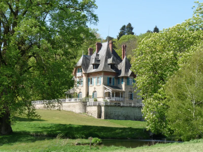
Le domaine de Boisse, mentionné dès la fin du XVIe siècle, est acheté en 1878 par Athanase Moreny, entrepreneur de travaux publics, qui décide de sa complète transformation. Il en confie la réalisation à l'architecte Stephen Sauvestre (1847-1919). Celui-ci a étudié l'architecture à l'Ecole spéciale d'architecture nouvellement créée à Paris. A partir de 1878, il construit plusieurs hôtels particuliers dans le quartier de la plaine de Monceaux. Il réalise pour son employeur Gustave Eiffel, le pavillon de la compagnie parisienne du gaz pour l'exposition universelle de 1878 puis participe en 1884 à la conception de la tour Eiffel pour l'exposition universelle de 1889. Au sommet de sa carrière, il est nommé architecte en chef des colonies et dessine le palais central des colonies, bâtiment principal de l'exposition coloniale, sur l'esplanade des Invalides. La famille Menier, industriels chocolatiers, lui confie la réalisation de plusieurs immeubles : plusieurs villas, l'usine de Noisiel dite « la cathédrale ». Le corps de logis s'élève sur une terrasse dominant un étang et de vastes prairies. Il est construit dans un style éclectique rappelant celui des villas balnéaires. L'architecte a utilisé les matériaux locaux : granit, chêne pour la charpente et les menuiseries mais aussi l'ardoise d'Angers pour la toiture ou la brique de Bourgogne. A l'intérieur, la distribution (niveau de caves, pièces de réception au rez-de-chaussée, chambres au deux niveaux supérieurs) et le mobilier d'origine ont été conservés (le domaine est resté dans la même famille). À l'ouest du logis s'élèvent les dépendances comprenant : les anciennes écuries/garage auxquelles est accolé un lavoir couvert, un poulailler à l'arrière, une grange étable et une maison d'habitation. Le parc, dont le plan porte la signature d'Edouard André est en grande partie conservé : à l'ouest, le long de l'allée qui mène à l'entrée principale, est aménagé un vaste jardin potager en terrasses. Une allée courbe mène à l'orangerie située au sud puis à l'étang, agrémenté de deux petits ponts à l'est.
Map and restricted areas
Open in the main mapRestricted zones
| Zone | Category | Limits | Conditions |
|---|---|---|---|
| Ctr Limoges Bellegarde |
Zone de contrôle civile | 50 m above ground level → 305 m above ground level | Flights above 50 metres are forbidden without the prior agreement of air traffic control |
| Tma Limoges |
Région de contrôle terminal | 305 m above ground level → 1219 m above sea level · 305 m above ground level → 3821 m above sea level · 701 m above sea level → 1311 m above sea level · 762 m above sea level → 2297 m above sea level · 914 m above sea level → 3821 m above sea level · 1219 m above sea level → 3821 m above sea level · 1311 m above sea level → 3821 m above sea level · 1372 m above sea level → 2297 m above sea level | Drone flights inside this zone are forbidden without the prior agreement of air traffic control |
Nearby aerodromes
Open aerodromes within 25 km of the spot, heliports included, with their distance and direction from the spot. Near an aerodrome, drone flying is prohibited or height-limited: check the UAS zones map.
| Aerodrome | Type | Distance | Elevation |
|---|---|---|---|
| Limoges Airport | Airport | 12 km S | 396 m |
| Centre Hospitalier Heliport | Heliport | 17 km S | 274 m |
| Aérodrome de Saint-Junien | Aerodrome | 23 km W | 275 m |
Aviation weather (METAR and TAF)
LFBL – Limoges Airport VFR
METAR
METAR LFBL 171400Z AUTO 22011KT 190V250 9999 SCT031 BKN037 15/10 Q1001 TEMPO 24015G25KT 4000 SHRA BKN010 BKN015TCU
- Wind
- 220°, 20 km/h
- Visibility
- 10 km or more
- Clouds
- Scattered (3-4/8) at 3,100 ft (940 m) ; Broken (5-7/8) at 3,700 ft (1130 m)
- Temperature
- 15 °C, dew point 10 °C
- QNH
- 1001 hPa
- Flight category
- VFR: ceiling > 3,000 ft and visibility > 5 mi
TAF
TAF LFBL 171100Z 1712/1812 24010KT 9999 BKN020 TEMPO 1712/1812 24015G25KT 4000 SHRA BKN010 BKN015TCU PROB30 TEMPO 1720/1724 24020G35KT 2000 TSRA BKN005 BKN015CB PROB30 TEMPO 1808/1812 26015G40KT 1500 TSRA BKN005 BKN010CB
| Period (local time) | Change | Wind | Visibility | Weather | Clouds |
|---|---|---|---|---|---|
| 17/11 13:00 → 18/11 13:00 | Initial conditions | 240°, 19 km/h | 10 km or more | Broken (5-7/8) at 2,000 ft (610 m) | |
| 17/11 13:00 → 18/11 13:00 | Temporarily | 240°, 28 km/h, gusts 46 km/h | 4.0 km | Showers of rain | Broken (5-7/8) at 1,000 ft (300 m) ; Broken (5-7/8) at 1,500 ft (460 m) (towering cumulus) |
| 17/11 21:00 → 18/11 01:00 | Temporarily, probability 30% | 240°, 37 km/h, gusts 65 km/h | 2.0 km | Thunderstorm rain | Broken (5-7/8) at 500 ft (150 m) ; Broken (5-7/8) at 1,500 ft (460 m) (cumulonimbus) |
| 18/11 09:00 → 18/11 13:00 | Temporarily, probability 30% | 260°, 28 km/h, gusts 74 km/h | 1.5 km | Thunderstorm rain | Broken (5-7/8) at 500 ft (150 m) ; Broken (5-7/8) at 1,000 ft (300 m) (cumulonimbus) |
Weather and Kp index
| Day | Weather | Temp. min. / max. | Wind | Rain | Max Kp |
|---|---|---|---|---|---|
| Tue 17 Nov | Fair | 11° / 15° | 32 km/h SW | 11 mm | 5 |
| Wed 18 Nov | Light rain | 10° / 12° | 28 km/h SW | 11 mm | 5 |
| Thu 19 Nov | Heavy rain | 8° / 10° | 31 km/h S | 20 mm | 3 |
| Fri 20 Nov | Rain | 7° / 10° | 25 km/h SW | 10 mm | 3 |
| Sat 21 Nov | Cloudy | 9° / 12° | 13 km/h SW | 1.3 mm | – |
| Sun 22 Nov | Showers | 8° / 11° | 26 km/h SW | 15 mm | – |
| Mon 23 Nov | Cloudy | 5° / 10° | 13 km/h SW | 0.9 mm | – |
Hour by hour: Tuesday 17 November
| Time | Weather | Temp. | Wind | Rain | Clouds | Kp |
|---|---|---|---|---|---|---|
| 15:00 | Fair | 15° | 28 km/h SW | – | 34 % | 4 |
| 16:00 | Showers | 15° | 29 km/h SW | 0.4 mm | 38 % | 4 |
| 17:00 | Showers | 12° | 31 km/h SW | 0.2 mm | 62 % | 4 |
| 18:00 | Showers | 12° | 31 km/h SW | 0.3 mm | 74 % | 4 |
| 19:00 | Rain | 11° | 32 km/h SW | 0.9 mm | 100 % | 5 |
| 20:00 | Heavy rain | 11° | 31 km/h SW | 1.2 mm | 100 % | 5 |
| 21:00 | Heavy rain | 11° | 30 km/h SW | 1.5 mm | 100 % | 5 |
| 22:00 | Heavy rain | 11° | 32 km/h SW | 1.8 mm | 100 % | 5 |
Hour by hour: Wednesday 18 November
| Time | Weather | Temp. | Wind | Rain | Clouds | Kp |
|---|---|---|---|---|---|---|
| 06:00 | Cloudy | 10° | 23 km/h SW | – | 100 % | 4 |
| 07:00 | Light rain | 10° | 25 km/h SW | 0.2 mm | 99 % | 4 |
| 08:00 | Rain | 10° | 25 km/h SW | 0.6 mm | 98 % | 4 |
| 09:00 | Rain | 10° | 23 km/h SW | 0.4 mm | 100 % | 4 |
| 10:00 | Light rain | 10° | 25 km/h SW | 0.2 mm | 97 % | 4 |
| 11:00 | Partly cloudy | 10° | 24 km/h SW | – | 48 % | 4 |
| 12:00 | Showers | 11° | 28 km/h SW | 0.2 mm | 62 % | 4 |
| 13:00 | Light rain | 12° | 27 km/h SW | 0.1 mm | 91 % | 3 |
| 14:00 | Rain | 12° | 28 km/h SW | 0.4 mm | 87 % | 3 |
| 15:00 | Cloudy | 11° | 26 km/h SW | – | 93 % | 3 |
| 16:00 | Partly cloudy | 11° | 24 km/h SW | – | 84 % | 3 |
| 17:00 | Partly cloudy | 11° | 21 km/h SW | – | 78 % | 3 |
| 18:00 | Cloudy | 10° | 21 km/h SW | – | 94 % | 3 |
| 19:00 | Cloudy | 10° | 22 km/h S | – | 100 % | 2 |
| 20:00 | Light rain | 10° | 23 km/h S | 0.1 mm | 100 % | 2 |
| 21:00 | Heavy rain | 10° | 23 km/h S | 1.1 mm | 100 % | 2 |
| 22:00 | Heavy rain | 10° | 22 km/h S | 1.9 mm | 100 % | 2 |
Sunrise and sunset
| Day | Dawn | Sunrise | Golden hour | Sunset | Dusk | Day length |
|---|---|---|---|---|---|---|
| Tue 17 Nov | 07:26 | 07:58 | 07:58–08:44 · 16:36–17:22 | 17:22 | 17:54 | 9 h 23 |
| Wed 18 Nov | 07:27 | 08:00 | 08:00–08:46 · 16:35–17:21 | 17:21 | 17:54 | 9 h 21 |
| Thu 19 Nov | 07:28 | 08:01 | 08:01–08:48 · 16:34–17:20 | 17:20 | 17:53 | 9 h 19 |
| Fri 20 Nov | 07:30 | 08:02 | 08:02–08:49 · 16:32–17:19 | 17:19 | 17:52 | 9 h 16 |
| Sat 21 Nov | 07:31 | 08:04 | 08:04–08:51 · 16:31–17:18 | 17:18 | 17:51 | 9 h 14 |
| Sun 22 Nov | 07:32 | 08:05 | 08:05–08:52 · 16:30–17:18 | 17:18 | 17:50 | 9 h 12 |
| Mon 23 Nov | 07:33 | 08:06 | 08:06–08:54 · 16:29–17:17 | 17:17 | 17:50 | 9 h 10 |


Reviews (0)
Log in to review this spot. Log in · Create a free account
No reviews yet. Share yours!