

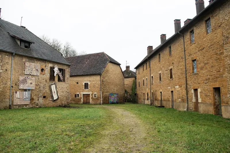
Baudin Forges Industrial Complex (also in the municipality of Sellières)
No reviews yet
Have you flown here? Share your experience with other pilots.
+ Write the first reviewHistory
Etabli vers 1794, le haut fourneau de Baudin se spécialise dans la production de fonte moulée. De dimension modeste, l'usine connaît entre 1827 et 1839 diverses extensions (atelier de fonderie, logements d'ouvriers, école). Sous l'influence du maître de forges Edmond Monnier, sont successivement édifiés une chapelle néogothique (1853-1854, vraisemblablement sur les plans de Narcisse Perrard) , un presbytère, le château patronal (vers 1865, agrandi vers 1885 ; architecture néo-gothique exceptionnelle ; mobilier liturgique copié sur celui du 13e siècle) complété d’une conciergerie et une orangerie (par les architectes Narcisse Perrard et Augustin Bidot). Vers 1860, l'usine connaît des difficultés : le haut fourneau est éteint en 1874 puis détruit. Spécialisée au 20e siècle dans la production de fonte émaillée, l'usine ferme ses portes en 1958. La plupart des bâtiments de production ont été rasés vers 1970-1975.
Map and restricted areas
Open in the main mapRestricted zones
| Zone | Category | Limits | Conditions |
|---|---|---|---|
| Zrt/zdt Riviera | ZRT/ZDT | From about 14,950 m to about 16,750 m above sea level | SUP AIP 233/24 · Du 16 janvier 2025 au 13 janvier 2027 |
Nearby aerodromes
Open aerodromes within 25 km of the spot, heliports included, with their distance and direction from the spot. Near an aerodrome, drone flying is prohibited or height-limited: check the UAS zones map.
| Aerodrome | Type | Distance | Elevation |
|---|---|---|---|
| Centre Hospitalier de Lons le Saunier Heliport | Heliport | 16 km S | 273 m |
| Lons Le Saulnier Courlaoux Airfield | Aerodrome | 18 km SW | 232 m |
| Aérodrome de Champagnole - Crotenay | Aerodrome | 20 km E | 532 m |
| Doucier ULM | Aerodrome | 23 km SE | 529 m |
Aviation weather (METAR and TAF)
LFGJ – Dole-Tavaux Airport VFR
METAR
METAR LFGJ 171400Z AUTO 20018KT CAVOK 17/13 Q0998 TEMPO 21020G35KT SCT020TCU
- Wind
- 200°, 33 km/h
- Visibility
- 10 km or more
- Clouds
- –
- Temperature
- 17 °C, dew point 13 °C
- QNH
- 998 hPa
- Flight category
- VFR: ceiling > 3,000 ft and visibility > 5 mi
TAF
TAF LFGJ 171400Z 1715/1724 21015G25KT CAVOK TEMPO 1715/1718 -SHRA FEW025TCU TEMPO 1721/1724 21020G37KT SHRA SCT040TCU PROB30 TEMPO 1721/1724 FEW035CB
| Period (local time) | Change | Wind | Visibility | Weather | Clouds |
|---|---|---|---|---|---|
| 17/11 16:00 → 18/11 01:00 | Initial conditions | 210°, 28 km/h, gusts 46 km/h | 10 km or more | No significant weather | No significant cloud |
| 17/11 16:00 → 17/11 19:00 | Temporarily | Showers of rain light | Few (1-2/8) at 2,500 ft (760 m) (towering cumulus) | ||
| 17/11 22:00 → 18/11 01:00 | Temporarily | 210°, 37 km/h, gusts 69 km/h | Showers of rain | Scattered (3-4/8) at 4,000 ft (1220 m) (towering cumulus) | |
| 17/11 22:00 → 18/11 01:00 | Temporarily, probability 30% | Few (1-2/8) at 3,500 ft (1070 m) (cumulonimbus) |
Weather and Kp index
Sunrise and sunset
| Day | Dawn | Sunrise | Golden hour | Sunset | Dusk | Day length |
|---|---|---|---|---|---|---|
| Tue 17 Nov | 07:10 | 07:43 | 07:43–08:31 · 16:15–17:02 | 17:02 | 17:35 | 9 h 18 |
| Wed 18 Nov | 07:12 | 07:45 | 07:45–08:32 · 16:14–17:01 | 17:01 | 17:34 | 9 h 16 |
| Thu 19 Nov | 07:13 | 07:46 | 07:46–08:34 · 16:12–17:00 | 17:00 | 17:33 | 9 h 13 |
| Fri 20 Nov | 07:14 | 07:48 | 07:48–08:35 · 16:11–16:59 | 16:59 | 17:32 | 9 h 11 |
| Sat 21 Nov | 07:16 | 07:49 | 07:49–08:37 · 16:10–16:58 | 16:58 | 17:32 | 9 h 09 |
| Sun 22 Nov | 07:17 | 07:50 | 07:50–08:39 · 16:09–16:57 | 16:57 | 17:31 | 9 h 06 |
| Mon 23 Nov | 07:18 | 07:52 | 07:52–08:40 · 16:08–16:56 | 16:56 | 17:30 | 9 h 04 |

Reviews (0)
Log in to review this spot. Log in · Create a free account
No reviews yet. Share yours!