

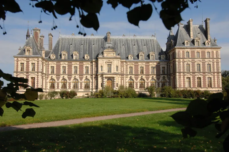
Grammont Castle
No reviews yet
Have you flown here? Share your experience with other pilots.
+ Write the first reviewHistory
Edifié entre 1882 et 1887 par l'architecte Eugène Danjoy, le château est le dernier grand édifice de ce type construit en Franche-Comté. Il remplace l'ancienne demeure incendiée durant la guerre de 1870-1871, dont les ruines subsistent au nord-est de l'édifice actuel. Construction de style néo-Louis XIII avec dissymétrie des ailes est et ouest pour simuler l'ancienneté du château et marquer la différence de fonction de chaque partie. Le gigantesque hall du rez-de-chaussée et le bow-window du pavillon ouest sont des références à l'architecture anglaise. Des structures métalliques sous-tendent le bâti à chaque niveau de planchers et dans l'escalier d'honneur. L'emploi de la brique et de la pierre en gros oeuvre est rare dans les demeures de la noblesse comtoise, traditionnellement en pierre et tuiles.
Map and restricted areas
Open in the main mapRestricted zones
| Zone | Category | Limits | Conditions |
|---|---|---|---|
| Jura | Zone réglementée | 244 m above ground level → 2297 m above sea level | Vols interdits sauf lorsque the official document of the zone l'autorise explicitement ou avec l'accord du gestionnaire de la zone lorsqu'il est désigné par the official document of the zone |
| (mirage 2000 Ne) | Zone réglementée | 457 m above ground level → 1524 m above ground level | Vols interdits sauf lorsque the official document of the zone l'autorise explicitement ou avec l'accord du gestionnaire de la zone lorsqu'il est désigné par the official document of the zone |
Nearby aerodromes
Open aerodromes within 25 km of the spot, heliports included, with their distance and direction from the spot. Near an aerodrome, drone flying is prohibited or height-limited: check the UAS zones map.
| Aerodrome | Type | Distance | Elevation |
|---|---|---|---|
| Base ULM de Fontaine les Clerval | Aerodrome | 15 km S | 401 m |
| Aérodrome de Vesoul-Frotey | Airport | 19 km NW | 381 m |
Aviation weather (METAR and TAF)
LFSX – Luxeuil-Saint-Sauveur (BA 116) Air Base MVFR
METAR
METAR LFSX 171230Z AUTO 24021KT 9999 BKN018 BKN024 BKN036 15/12 Q0996
- Wind
- 240°, 39 km/h
- Visibility
- 10 km or more
- Clouds
- Broken (5-7/8) at 1,800 ft (550 m) ; Broken (5-7/8) at 2,400 ft (730 m) ; Broken (5-7/8) at 3,600 ft (1100 m)
- Temperature
- 15 °C, dew point 12 °C
- QNH
- 996 hPa
- Flight category
- MVFR: ceiling 1,000–3,000 ft or visibility 3–5 mi
TAF
TAF LFSX 170800Z 1709/1809 21015G25KT 9999 BKN015 TEMPO 1709/1715 21020G35KT TEMPO 1714/1720 SHRA BKN010CB BECMG 1718/1720 BKN040 TEMPO 1720/1806 21020G35KT
| Period (local time) | Change | Wind | Visibility | Weather | Clouds |
|---|---|---|---|---|---|
| 17/11 10:00 → 17/11 19:00 | Initial conditions | 210°, 28 km/h, gusts 46 km/h | 10 km or more | Broken (5-7/8) at 1,500 ft (460 m) | |
| 17/11 10:00 → 17/11 16:00 | Temporarily | 210°, 37 km/h, gusts 65 km/h | |||
| 17/11 15:00 → 17/11 21:00 | Temporarily | Showers of rain | Broken (5-7/8) at 1,000 ft (300 m) (cumulonimbus) | ||
| 17/11 19:00 → 18/11 10:00 | Becoming | 210°, 28 km/h, gusts 46 km/h | 10 km or more | Broken (5-7/8) at 4,000 ft (1220 m) | |
| 17/11 21:00 → 18/11 07:00 | Temporarily | 210°, 37 km/h, gusts 65 km/h |
Weather and Kp index
| Day | Weather | Temp. min. / max. | Wind | Rain | Max Kp |
|---|---|---|---|---|---|
| Tue 17 Nov | Fair | 10° / 15° | 34 km/h SW | 2.2 mm | 5 |
| Wed 18 Nov | Showers | 8° / 11° | 34 km/h SW | 12 mm | 5 |
| Thu 19 Nov | Showers | 8° / 11° | 30 km/h SW | 14 mm | 3 |
| Fri 20 Nov | Showers | 7° / 9° | 32 km/h SW | 18 mm | 3 |
| Sat 21 Nov | Partly cloudy | 5° / 10° | 22 km/h SW | 6.1 mm | – |
| Sun 22 Nov | Rain | 4° / 7° | 19 km/h SW | 19 mm | – |
| Mon 23 Nov | Partly cloudy | 5° / 8° | 25 km/h SW | 9.8 mm | – |
Hour by hour: Tuesday 17 November
| Time | Weather | Temp. | Wind | Rain | Clouds | Kp |
|---|---|---|---|---|---|---|
| 14:00 | Fair | 14° | 32 km/h SW | – | 38 % | 4 |
| 15:00 | Partly cloudy | 15° | 30 km/h SW | – | 77 % | 4 |
| 16:00 | Partly cloudy | 15° | 29 km/h SW | – | 65 % | 4 |
| 17:00 | Partly cloudy | 14° | 25 km/h SW | – | 79 % | 4 |
| 18:00 | Showers | 14° | 26 km/h SW | 0.2 mm | 64 % | 4 |
| 19:00 | Light rain | 13° | 27 km/h SW | 0.2 mm | 96 % | 5 |
| 20:00 | Cloudy | 12° | 28 km/h SW | – | 94 % | 5 |
| 21:00 | Light rain | 12° | 30 km/h SW | 0.1 mm | 95 % | 5 |
| 22:00 | Heavy rain | 12° | 34 km/h SW | 1.1 mm | 100 % | 5 |
Hour by hour: Wednesday 18 November
| Time | Weather | Temp. | Wind | Rain | Clouds | Kp |
|---|---|---|---|---|---|---|
| 06:00 | Light rain | 9° | 25 km/h SW | 0.4 mm | 98 % | 4 |
| 07:00 | Light rain | 9° | 26 km/h SW | 0.3 mm | 100 % | 4 |
| 08:00 | Rain | 9° | 26 km/h SW | 0.8 mm | 99 % | 4 |
| 09:00 | Light rain | 9° | 27 km/h SW | 0.3 mm | 100 % | 4 |
| 10:00 | Rain | 10° | 28 km/h SW | 0.5 mm | 100 % | 4 |
| 11:00 | Heavy rain | 10° | 30 km/h SW | 1.2 mm | 92 % | 4 |
| 12:00 | Showers | 11° | 30 km/h SW | 2.3 mm | 76 % | 4 |
| 13:00 | Showers | 11° | 32 km/h SW | 1.4 mm | 70 % | 3 |
| 14:00 | Showers | 11° | 28 km/h SW | 2.3 mm | 44 % | 3 |
| 15:00 | Showers | 10° | 27 km/h W | 0.4 mm | 58 % | 3 |
| 16:00 | Showers | 11° | 27 km/h SW | 0.8 mm | 50 % | 3 |
| 17:00 | Showers | 9° | 23 km/h SW | 0.4 mm | 68 % | 3 |
| 18:00 | Fair | 9° | 22 km/h SW | – | 33 % | 3 |
| 19:00 | Fair | 9° | 24 km/h SW | – | 32 % | 2 |
| 20:00 | Partly cloudy | 9° | 23 km/h SW | – | 43 % | 2 |
| 21:00 | Partly cloudy | 8° | 22 km/h SW | – | 83 % | 2 |
| 22:00 | Partly cloudy | 8° | 21 km/h SW | – | 54 % | 2 |
Sunrise and sunset
| Day | Dawn | Sunrise | Golden hour | Sunset | Dusk | Day length |
|---|---|---|---|---|---|---|
| Tue 17 Nov | 07:09 | 07:42 | 07:42–08:30 · 16:08–16:56 | 16:56 | 17:30 | 9 h 14 |
| Wed 18 Nov | 07:10 | 07:44 | 07:44–08:32 · 16:07–16:55 | 16:55 | 17:29 | 9 h 11 |
| Thu 19 Nov | 07:11 | 07:45 | 07:45–08:34 · 16:06–16:54 | 16:54 | 17:28 | 9 h 09 |
| Fri 20 Nov | 07:13 | 07:47 | 07:47–08:35 · 16:04–16:53 | 16:53 | 17:27 | 9 h 06 |
| Sat 21 Nov | 07:14 | 07:48 | 07:48–08:37 · 16:03–16:52 | 16:52 | 17:26 | 9 h 04 |
| Sun 22 Nov | 07:15 | 07:49 | 07:49–08:39 · 16:02–16:51 | 16:51 | 17:26 | 9 h 02 |
| Mon 23 Nov | 07:17 | 07:51 | 07:51–08:40 · 16:01–16:51 | 16:51 | 17:25 | 8 h 59 |

Reviews (0)
Log in to review this spot. Log in · Create a free account
No reviews yet. Share yours!