

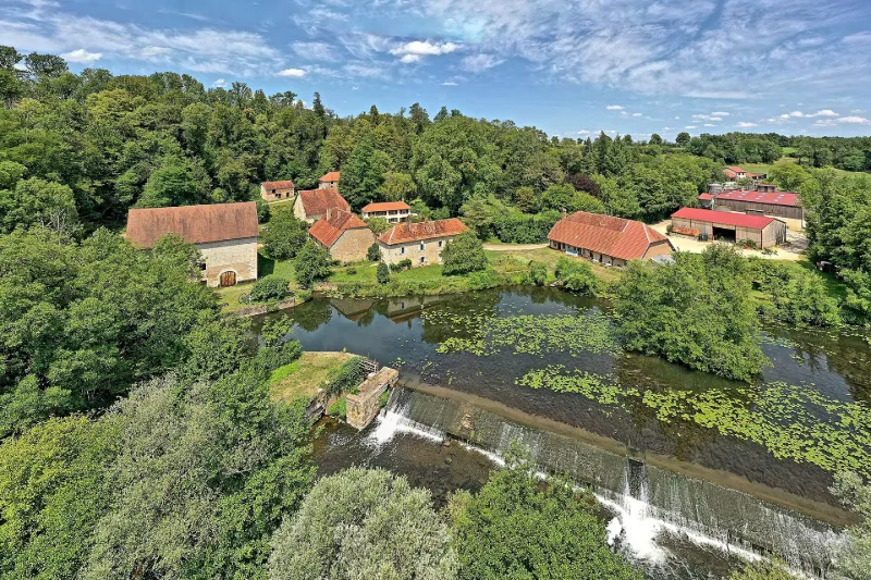
Montagney Forge
No reviews yet
Have you flown here? Share your experience with other pilots.
+ Write the first reviewHistory
2e moitié 18e siècle ; 1ère moitié 19e siècle La forge de Montagney obtint sa permission de mise en activité en 1689. En 1748, elle fabriquait principalement des boulets de canons. Vers 1810, elle est achetée par Monsieur de Grammont qui la remet à neuf. Elle comportait un haut-fourneau, deux feux d'affinerie, un martinet, un patouillet et deux moulins à blé. En 1828, elle produisait 200 tonnes de fonte affinée, puis transformée en fil de fer. En 1833, une tréfilerie complète l'ensemble. L'apogée se situe vers 1840, mais le déclin est rapide. Après l'arrêt en 1850, on eut un moulin, puis une centrale électrique (en 1922) , tandis que les autres bâtiments sont utilisés par une exploitation agricole. L'ensemble conservé présente encore le barrage, un canal, le haut-fourneau, une partie de la halle à charbon, une ancienne halle ouverte (transformée postérieurement en atelier et magasin) , des écuries, un bâtiment de logements ouvriers à étage, un bâtiment de logement du directeur, la maison du maître de forge (de la deuxième moitié du 18e siècle, avec des décors intérieurs).
Map and restricted areas
Open in the main mapRestricted zones
| Zone | Category | Limits | Conditions |
|---|---|---|---|
| Jura | Zone réglementée | 244 m above ground level → 2297 m above sea level | Vols interdits sauf lorsque the official document of the zone l'autorise explicitement ou avec l'accord du gestionnaire de la zone lorsqu'il est désigné par the official document of the zone |
| Mirage 2000 Ne | Zone réglementée | 1524 m above ground level → 3821 m above sea level | Vols interdits sauf lorsque the official document of the zone l'autorise explicitement ou avec l'accord du gestionnaire de la zone lorsqu'il est désigné par the official document of the zone |
Nearby aerodromes
Open aerodromes within 25 km of the spot, heliports included, with their distance and direction from the spot. Near an aerodrome, drone flying is prohibited or height-limited: check the UAS zones map.
| Aerodrome | Type | Distance | Elevation |
|---|---|---|---|
| Base ULM de Fontaine les Clerval | Aerodrome | 14 km SE | 401 m |
| Aérodrome de Vesoul-Frotey | Airport | 18 km NW | 381 m |
Aviation weather (METAR and TAF)
LFSX – Luxeuil-Saint-Sauveur (BA 116) Air Base VFR
METAR
METAR LFSX 171400Z AUTO 24016KT 200V260 9999 FEW025 SCT039 BKN052 16/12 Q0997
- Wind
- 240°, 30 km/h
- Visibility
- 10 km or more
- Clouds
- Few (1-2/8) at 2,500 ft (760 m) ; Scattered (3-4/8) at 3,900 ft (1190 m) ; Broken (5-7/8) at 5,200 ft (1580 m)
- Temperature
- 16 °C, dew point 12 °C
- QNH
- 997 hPa
- Flight category
- VFR: ceiling > 3,000 ft and visibility > 5 mi
TAF
TAF LFSX 171400Z 1715/1815 23015G25KT 9999 BKN030 PROB30 TEMPO 1715/1720 SHRA BKN015TCU BECMG 1720/1722 21025G40KT BECMG 1806/1808 23015G30KT
| Period (local time) | Change | Wind | Visibility | Weather | Clouds |
|---|---|---|---|---|---|
| 17/11 16:00 → 17/11 21:00 | Initial conditions | 230°, 28 km/h, gusts 46 km/h | 10 km or more | Broken (5-7/8) at 3,000 ft (910 m) | |
| 17/11 16:00 → 17/11 21:00 | Temporarily, probability 30% | Showers of rain | Broken (5-7/8) at 1,500 ft (460 m) (towering cumulus) | ||
| 17/11 21:00 → 18/11 07:00 | Becoming | 210°, 46 km/h, gusts 74 km/h | 10 km or more | Broken (5-7/8) at 3,000 ft (910 m) | |
| 18/11 07:00 → 18/11 16:00 | Becoming | 230°, 28 km/h, gusts 56 km/h | 10 km or more | Broken (5-7/8) at 3,000 ft (910 m) |
Weather and Kp index
Sunrise and sunset
| Day | Dawn | Sunrise | Golden hour | Sunset | Dusk | Day length |
|---|---|---|---|---|---|---|
| Tue 17 Nov | 07:09 | 07:42 | 07:42–08:31 · 16:09–16:57 | 16:57 | 17:31 | 9 h 14 |
| Wed 18 Nov | 07:10 | 07:44 | 07:44–08:32 · 16:08–16:56 | 16:56 | 17:30 | 9 h 12 |
| Thu 19 Nov | 07:12 | 07:45 | 07:45–08:34 · 16:06–16:55 | 16:55 | 17:29 | 9 h 09 |
| Fri 20 Nov | 07:13 | 07:47 | 07:47–08:35 · 16:05–16:54 | 16:54 | 17:28 | 9 h 07 |
| Sat 21 Nov | 07:14 | 07:48 | 07:48–08:37 · 16:04–16:53 | 16:53 | 17:27 | 9 h 04 |
| Sun 22 Nov | 07:16 | 07:50 | 07:50–08:39 · 16:03–16:52 | 16:52 | 17:26 | 9 h 02 |
| Mon 23 Nov | 07:17 | 07:51 | 07:51–08:40 · 16:02–16:51 | 16:51 | 17:26 | 9 h 00 |

Reviews (0)
Log in to review this spot. Log in · Create a free account
No reviews yet. Share yours!