

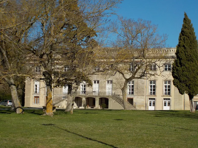
Former episcopal palace or former castle, later children's social care home
No reviews yet
Have you flown here? Share your experience with other pilots.
+ Write the first reviewHistory
Diocèse créé en 1317 par démembrement de celui de Toulouse. Au 15e siècle, restauration de l'ensemble des bâtiments de l'abbaye, y compris le palais épiscopal, en ruine. Dans la seconde moitié du 16e siècle, l'évêché est laissé à l'abandon. Supprimé à la Révolution, l'église devient paroissiale et le palais épiscopal est vendu. Le palais forme une entité indépendante, au sud des bâtiments conventuels et de l'église, s'appuyant directement sur la galerie méridionale du cloître. Il occupe l'un des anciens bâtiments conventuels (l'ancien réfectoire - dortoir) reconstruit, comme la salle capitulaire, à l'époque gothique. Les niveaux et la distribution intérieure ont été modifiés. Le rez-de-chaussée est rythmé par quatre arcs diaphragmes aux claveaux appareillés, portant l'année 1767. Le palais épiscopal moderne cache un bâtiment plus ancien, des 14e-15e siècles, dont subsistent de nombreux vestiges (meurtrière, fenêtre flamboyante, ouvertures murées...). Trois vestiges de tours circulaires occupaient les angles de la bâtisse. A l'époque moderne, ajout de deux corps de bâtiments sur cour, destinés à assurer la circulation des différents niveaux. La résidence épiscopale se concentre alors sur les ailes sud et ouest. Le grand corps de bâtiment sud a été le dernier construit, à la fin du 18e siècle. Il tourne le dos au palais médiéval et possède son autonomie. Il se compose d'un corps central encadré par deux ailes latérales peu saillantes. A l'intérieur, les salles de réception et les chambres ont reçu un décor de gypseries, cheminées de marbre, lambris.
Map and restricted areas
Open in the main mapRestricted zones
| Zone | Category | Limits | Conditions |
|---|---|---|---|
| Tma Toulouse |
Région de contrôle terminal | 457 m above ground level → 2297 m above sea level · 610 m above sea level → 914 m above sea level · 610 m above sea level → 2297 m above sea level · 732 m above sea level → 914 m above sea level · 762 m above sea level → 2297 m above sea level · 914 m above sea level → 1219 m above sea level · 914 m above sea level → 1219 m above sea level · 914 m above sea level → 2297 m above sea level · 914 m above sea level → 2297 m above sea level · 914 m above sea level → 2297 m above sea level · 1067 m above sea level → 2297 m above sea level · 1067 m above sea level → 3821 m above sea level · 1219 m above sea level → 2297 m above sea level · 1219 m above sea level → 2297 m above sea level · 1219 m above sea level → 2297 m above sea level · 1529 m above sea level → 3821 m above sea level · 1529 m above sea level → 3821 m above sea level · 1529 m above sea level → 3821 m above sea level | Drone flights inside this zone are forbidden without the prior agreement of air traffic control |
| Istres | Zone réglementée | 5491 m above sea level → 30766 m above sea level | Vols interdits sauf lorsque the official document of the zone l'autorise explicitement ou avec l'accord du gestionnaire de la zone lorsqu'il est désigné par the official document of the zone |
Nearby aerodromes
Open aerodromes within 25 km of the spot, heliports included, with their distance and direction from the spot. Near an aerodrome, drone flying is prohibited or height-limited: check the UAS zones map.
| Aerodrome | Type | Distance | Elevation |
|---|---|---|---|
| Aérodrome de Castelnaudary-Villeneuve | Aerodrome | 9.2 km W | 168 m |
| Aérodrome de la Montagne Noire | Aerodrome | 9.3 km N | 448 m |
| Revel Montgey Airfield | Aerodrome | 17 km N | 196 m |
Aviation weather (METAR and TAF)
LFMK – Carcassonne Airport VFR
METAR
METAR LFMK 171330Z AUTO VRB03KT 9999 FEW028/// SCT130/// ///TCU 15/14 Q1004 NOSIG
- Wind
- Variable, 6 km/h
- Visibility
- 10 km or more
- Clouds
- Few (1-2/8) at 2,800 ft (850 m) ; Scattered (3-4/8) at 13,000 ft (3960 m)
- Temperature
- 15 °C, dew point 14 °C
- QNH
- 1004 hPa
- Flight category
- VFR: ceiling > 3,000 ft and visibility > 5 mi
TAF
TAF LFMK 170800Z 1709/1809 08008KT 9999 BKN070 TEMPO 1709/1712 -RA SCT004 BKN010 BECMG 1710/1712 VRB03KT TEMPO 1712/1720 SCT025TCU BECMG 1720/1722 CAVOK PROB30 TEMPO 1801/1807 3000 BR BECMG 1806/1808 27010KT 4000 RA BKN020 BKN030
| Period (local time) | Change | Wind | Visibility | Weather | Clouds |
|---|---|---|---|---|---|
| 17/11 10:00 → 17/11 11:00 | Initial conditions | 080°, 15 km/h | 10 km or more | Broken (5-7/8) at 7,000 ft (2130 m) | |
| 17/11 10:00 → 17/11 13:00 | Temporarily | Rain light | Scattered (3-4/8) at 400 ft (120 m) ; Broken (5-7/8) at 1,000 ft (300 m) | ||
| 17/11 11:00 → 17/11 21:00 | Becoming | Variable, 6 km/h | 10 km or more | Broken (5-7/8) at 7,000 ft (2130 m) | |
| 17/11 13:00 → 17/11 21:00 | Temporarily | Scattered (3-4/8) at 2,500 ft (760 m) (towering cumulus) | |||
| 17/11 21:00 → 18/11 07:00 | Becoming | Variable, 6 km/h | 10 km or more | No significant weather | No significant cloud |
| 18/11 02:00 → 18/11 08:00 | Temporarily, probability 30% | 3.0 km | Mist | ||
| 18/11 07:00 → 18/11 10:00 | Becoming | 270°, 19 km/h | 4.0 km | Rain | Broken (5-7/8) at 2,000 ft (610 m) ; Broken (5-7/8) at 3,000 ft (910 m) |
Weather and Kp index
| Day | Weather | Temp. min. / max. | Wind | Rain | Max Kp |
|---|---|---|---|---|---|
| Tue 17 Nov | Cloudy | 11° / 15° | 11 km/h N | 0.2 mm | 5 |
| Wed 18 Nov | Fair | 11° / 18° | 31 km/h E | 4.4 mm | 5 |
| Thu 19 Nov | Fair | 9° / 16° | 30 km/h E | 5.5 mm | 3 |
| Fri 20 Nov | Partly cloudy | 7° / 16° | 23 km/h NW | – | 3 |
| Sat 21 Nov | Cloudy | 8° / 15° | 23 km/h E | – | – |
| Sun 22 Nov | Fair | 11° / 14° | 26 km/h W | 1.6 mm | – |
| Mon 23 Nov | Cloudy | 7° / 14° | 18 km/h W | – | – |
Hour by hour: Tuesday 17 November
| Time | Weather | Temp. | Wind | Rain | Clouds | Kp |
|---|---|---|---|---|---|---|
| 15:00 | Cloudy | 15° | 4 km/h SW | – | 100 % | 4 |
| 16:00 | Cloudy | 14° | 8 km/h SE | – | 99 % | 4 |
| 17:00 | Cloudy | 14° | 8 km/h N | – | 100 % | 4 |
| 18:00 | Cloudy | 13° | 5 km/h SW | – | 100 % | 4 |
| 19:00 | Cloudy | 13° | 5 km/h S | – | 98 % | 5 |
| 20:00 | Cloudy | 12° | 11 km/h N | – | 100 % | 5 |
| 21:00 | Light rain | 12° | 11 km/h N | 0.2 mm | 100 % | 5 |
| 22:00 | Cloudy | 12° | 7 km/h N | – | 88 % | 5 |
Hour by hour: Wednesday 18 November
| Time | Weather | Temp. | Wind | Rain | Clouds | Kp |
|---|---|---|---|---|---|---|
| 06:00 | Rain | 12° | 14 km/h NW | 0.9 mm | 100 % | 4 |
| 07:00 | Heavy rain | 13° | 15 km/h NW | 1.2 mm | 100 % | 4 |
| 08:00 | Heavy rain | 13° | 19 km/h W | 1.1 mm | 100 % | 4 |
| 09:00 | Light rain | 13° | 19 km/h W | 0.4 mm | 100 % | 4 |
| 10:00 | Cloudy | 13° | 21 km/h W | – | 100 % | 4 |
| 11:00 | Cloudy | 14° | 18 km/h W | – | 97 % | 4 |
| 12:00 | Fair | 15° | 20 km/h W | – | 38 % | 4 |
| 13:00 | Fair | 17° | 21 km/h W | – | 20 % | 3 |
| 14:00 | Clear sky | 17° | 19 km/h W | – | 6 % | 3 |
| 15:00 | Fair | 18° | 16 km/h NW | – | 36 % | 3 |
| 16:00 | Partly cloudy | 17° | 13 km/h NW | – | 46 % | 3 |
| 17:00 | Partly cloudy | 15° | 7 km/h NW | – | 49 % | 3 |
| 18:00 | Partly cloudy | 13° | 5 km/h N | – | 84 % | 3 |
| 19:00 | Partly cloudy | 12° | 6 km/h SE | – | 86 % | 2 |
| 20:00 | Partly cloudy | 12° | 12 km/h E | – | 62 % | 2 |
| 21:00 | Cloudy | 12° | 19 km/h E | – | 99 % | 2 |
| 22:00 | Cloudy | 12° | 23 km/h E | – | 100 % | 2 |
Sunrise and sunset
| Day | Dawn | Sunrise | Golden hour | Sunset | Dusk | Day length |
|---|---|---|---|---|---|---|
| Tue 17 Nov | 07:17 | 07:48 | 07:48–08:31 · 16:43–17:26 | 17:26 | 17:57 | 9 h 38 |
| Wed 18 Nov | 07:18 | 07:49 | 07:49–08:32 · 16:42–17:25 | 17:25 | 17:56 | 9 h 36 |
| Thu 19 Nov | 07:19 | 07:50 | 07:50–08:34 · 16:41–17:24 | 17:24 | 17:55 | 9 h 34 |
| Fri 20 Nov | 07:20 | 07:51 | 07:51–08:35 · 16:40–17:24 | 17:24 | 17:55 | 9 h 32 |
| Sat 21 Nov | 07:22 | 07:53 | 07:53–08:37 · 16:39–17:23 | 17:23 | 17:54 | 9 h 30 |
| Sun 22 Nov | 07:23 | 07:54 | 07:54–08:38 · 16:38–17:22 | 17:22 | 17:53 | 9 h 28 |
| Mon 23 Nov | 07:24 | 07:55 | 07:55–08:39 · 16:37–17:21 | 17:21 | 17:53 | 9 h 26 |

Reviews (0)
Log in to review this spot. Log in · Create a free account
No reviews yet. Share yours!