

Cabrenc Towers (also in the municipality of Lamanère)
No reviews yet
Have you flown here? Share your experience with other pilots.
+ Write the first reviewHistory
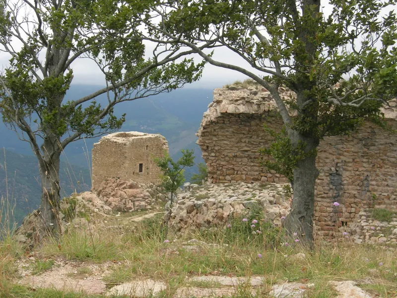
L'ensemble se compose essentiellement de trois constructions distinctes occupant les sommets d'une arête granitique. Au nord, une tour polygonale à l'extérieur, quadrangulaire à l'intérieur, élevée de trois niveaux voûtés en berceau brisé. Elle est entourée des vestiges d'une "chemise" à peu près circulaire, soulignée par un fossé. Au centre, la deuxième tour offre un plan plus complexe. La tour polygonale semble être le résultat de l'adjonction d'un bâtiment quadrangulaire au sud-est à un bâtiment préexistant au nord, polygonal. La porte de l'enceinte est défendue par une série de meurtrières. Au sud, la plateforme sommitale plus large a permis le développement de constructions plus amples. Sur le flanc sud-ouest subsiste un mur qui se développe suivant un tracé polygonal et dans lequel le vestige de la porte d'entrée est encore apparent. Cette première enceinte se termine par une plateforme au nord-est. Occupant la crête au-dessus de cet ensemble, est encore visible le tracé de l'enceinte supérieure avec, en son centre, les vestiges d'une construction qui semble être la chapelle. Une salle voûtée, dont il ne reste que le mur nord, occupe l'extrémité nord du site.
Map and restricted areas
Open in the main mapRestricted zones
| Zone | Category | Limits | Conditions |
|---|---|---|---|
| Istres | Zone réglementée | 5491 m above sea level → 30766 m above sea level | Vols interdits sauf lorsque the official document of the zone l'autorise explicitement ou avec l'accord du gestionnaire de la zone lorsqu'il est désigné par the official document of the zone |
Nearby aerodromes
Open aerodromes within 25 km of the spot, heliports included, with their distance and direction from the spot. Near an aerodrome, drone flying is prohibited or height-limited: check the UAS zones map.
| Aerodrome | Type | Distance | Elevation |
|---|---|---|---|
| Aerodrom Tapioles | Aerodrome | 17 km S | 240 m |
| Beuda Besalu Private Airstrip | Aerodrome | 22 km SE | 200 m |
Aviation weather (METAR and TAF)
LFMP – Perpignan-Rivesaltes (Llabanère) Airport VFR
METAR
METAR LFMP 171330Z AUTO VRB02KT CAVOK 17/13 Q1006 NOSIG
- Wind
- Variable, 4 km/h
- Visibility
- 10 km or more
- Clouds
- –
- Temperature
- 17 °C, dew point 13 °C
- QNH
- 1006 hPa
- Flight category
- VFR: ceiling > 3,000 ft and visibility > 5 mi
TAF
TAF LFMP 170800Z 1709/1809 VRB02KT 9999 BKN008 BECMG 1710/1712 CAVOK BECMG 1806/1808 28012KT
| Period (local time) | Change | Wind | Visibility | Weather | Clouds |
|---|---|---|---|---|---|
| 17/11 10:00 → 17/11 11:00 | Initial conditions | Variable, 4 km/h | 10 km or more | Broken (5-7/8) at 800 ft (240 m) | |
| 17/11 11:00 → 18/11 07:00 | Becoming | Variable, 4 km/h | 10 km or more | No significant weather | No significant cloud |
| 18/11 07:00 → 18/11 10:00 | Becoming | 280°, 22 km/h | 10 km or more | No significant weather | No significant cloud |
Weather and Kp index
| Day | Weather | Temp. min. / max. | Wind | Rain | Max Kp |
|---|---|---|---|---|---|
| Tue 17 Nov | Cloudy | 10° / 14° | 15 km/h W | – | 5 |
| Wed 18 Nov | Rain | 8° / 13° | 17 km/h SW | 2.9 mm | 5 |
| Thu 19 Nov | Showers | 6° / 13° | 33 km/h SW | 9.3 mm | 3 |
| Fri 20 Nov | Partly cloudy | 5° / 12° | 6 km/h NW | 0.6 mm | 3 |
| Sat 21 Nov | Cloudy | 5° / 11° | 10 km/h SW | 0.3 mm | – |
| Sun 22 Nov | Light rain | 7° / 10° | 5 km/h E | 1.3 mm | – |
| Mon 23 Nov | Partly cloudy | 4° / 10° | 11 km/h S | 0.1 mm | – |
Hour by hour: Tuesday 17 November
| Time | Weather | Temp. | Wind | Rain | Clouds | Kp |
|---|---|---|---|---|---|---|
| 15:00 | Cloudy | 14° | 9 km/h S | – | 100 % | 4 |
| 16:00 | Cloudy | 13° | 9 km/h S | – | 99 % | 4 |
| 17:00 | Cloudy | 12° | 9 km/h SW | – | 99 % | 4 |
| 18:00 | Cloudy | 12° | 9 km/h W | – | 99 % | 4 |
| 19:00 | Cloudy | 12° | 13 km/h W | – | 95 % | 5 |
| 20:00 | Partly cloudy | 12° | 12 km/h W | – | 80 % | 5 |
| 21:00 | Partly cloudy | 11° | 15 km/h W | – | 86 % | 5 |
| 22:00 | Cloudy | 11° | 13 km/h NW | – | 90 % | 5 |
Hour by hour: Wednesday 18 November
| Time | Weather | Temp. | Wind | Rain | Clouds | Kp |
|---|---|---|---|---|---|---|
| 06:00 | Partly cloudy | 9° | 8 km/h N | – | 58 % | 4 |
| 07:00 | Partly cloudy | 11° | 7 km/h N | – | 38 % | 4 |
| 08:00 | Partly cloudy | 10° | 8 km/h NW | – | 48 % | 4 |
| 09:00 | Partly cloudy | 12° | 8 km/h S | – | 53 % | 4 |
| 10:00 | Fair | 12° | 7 km/h S | – | 38 % | 4 |
| 11:00 | Cloudy | 13° | 10 km/h S | – | 88 % | 4 |
| 12:00 | Rain | 12° | 11 km/h SE | 0.4 mm | 98 % | 4 |
| 13:00 | Rain | 11° | 12 km/h SE | 0.6 mm | 98 % | 3 |
| 14:00 | Rain | 11° | 12 km/h S | 0.6 mm | 99 % | 3 |
| 15:00 | Showers | 11° | 10 km/h SE | 0.4 mm | 78 % | 3 |
| 16:00 | Light rain | 11° | 8 km/h SE | 0.2 mm | 98 % | 3 |
| 17:00 | Light rain | 10° | 4 km/h E | 0.2 mm | 99 % | 3 |
| 18:00 | Fog | 10° | 5 km/h SE | – | 100 % | 3 |
| 19:00 | Fog | 10° | 5 km/h S | – | 99 % | 2 |
| 20:00 | Fog | 10° | 6 km/h SW | – | 98 % | 2 |
| 21:00 | Fair | 10° | 10 km/h SW | – | 35 % | 2 |
| 22:00 | Partly cloudy | 9° | 13 km/h SW | – | 70 % | 2 |
Sunrise and sunset
| Day | Dawn | Sunrise | Golden hour | Sunset | Dusk | Day length |
|---|---|---|---|---|---|---|
| Tue 17 Nov | 07:13 | 07:43 | 07:43–08:26 · 16:44–17:26 | 17:26 | 17:57 | 9 h 43 |
| Wed 18 Nov | 07:14 | 07:44 | 07:44–08:27 · 16:43–17:26 | 17:26 | 17:56 | 9 h 41 |
| Thu 19 Nov | 07:15 | 07:46 | 07:46–08:28 · 16:42–17:25 | 17:25 | 17:55 | 9 h 39 |
| Fri 20 Nov | 07:16 | 07:47 | 07:47–08:30 · 16:41–17:24 | 17:24 | 17:55 | 9 h 37 |
| Sat 21 Nov | 07:17 | 07:48 | 07:48–08:31 · 16:40–17:23 | 17:23 | 17:54 | 9 h 35 |
| Sun 22 Nov | 07:18 | 07:49 | 07:49–08:32 · 16:40–17:23 | 17:23 | 17:53 | 9 h 33 |
| Mon 23 Nov | 07:20 | 07:50 | 07:50–08:34 · 16:39–17:22 | 17:22 | 17:53 | 9 h 31 |



Reviews (0)
Log in to review this spot. Log in · Create a free account
No reviews yet. Share yours!