

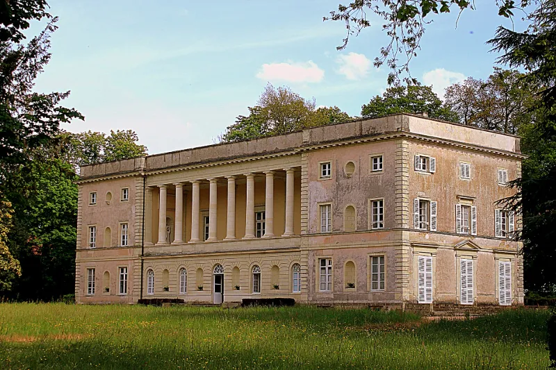
La Noë de Bel Air Castle
No reviews yet
Have you flown here? Share your experience with other pilots.
+ Write the first reviewHistory
A l'emplacement d'une maison noble du 17e siècle, totalement détruite pendant la Révolution, construction de l'ensemble de la Noë dans la première moitié du 19e siècle. L'orangerie et les communs, bâtis sans doute vers 1823-1826, sont ordonnés autour d'une cour carrée et construits selon le modèle toscan avec encadrements de briques. Le château de style italianisant est construit entre 1835 et 1837 par un élève de Lemot, Louis-Joseph Chaigneau, influencé par les grands architectes nantais de l'époque Empire : Crucy et Ceineray. La villa possède une vaste loggia à ordre colossal toscan sur la façade antérieure de style très néo-palladien. L'ensemble comprend un parc d'agrément et un parc d'agriculture, dont le plan est dû à l'ingénieur géomètre Bosmel (1839). Le parc à l'anglaise est groupé autour d'un étang ; les percées en étoile convergent vers la loggia de la maison. Il s'agit d'un ensemble exceptionnel d'architecture rustique à l'italienne influencé par le foyer clissonnais.
Map and restricted areas
Open in the main mapRestricted zones
Nearby aerodromes
Open aerodromes within 25 km of the spot, heliports included, with their distance and direction from the spot. Near an aerodrome, drone flying is prohibited or height-limited: check the UAS zones map.
| Aerodrome | Type | Distance | Elevation |
|---|---|---|---|
| Aérodrome de l'Emonière | Aerodrome | 14 km S | 37 m |
| Quai Moncousu Heliport | Heliport | 20 km W | 23 m |
| Nantes Atlantique Airport | Airport | 24 km W | 27 m |
Aviation weather (METAR and TAF)
LFRS – Nantes Atlantique Airport MVFR
METAR
METAR LFRS 171400Z AUTO 23014G24KT 190V250 9999 BKN021 OVC027 16/13 Q0994 BECMG 4500 -RA BKN020TCU
- Wind
- 230°, 26 km/h, gusts 44 km/h
- Visibility
- 10 km or more
- Clouds
- Broken (5-7/8) at 2,100 ft (640 m) ; Overcast (8/8) at 2,700 ft (820 m)
- Temperature
- 16 °C, dew point 13 °C
- QNH
- 994 hPa
- Flight category
- MVFR: ceiling 1,000–3,000 ft or visibility 3–5 mi
TAF
TAF AMD LFRS 171353Z 1713/1818 24015KT 9999 BKN020 BECMG 1713/1716 23020G30KT PROB30 TEMPO 1713/1715 4500 -SHRA SCT025TCU BECMG 1715/1717 4500 -RA BKN020TCU TEMPO 1716/1719 24030G45KT 2500 TSRA BKN013 BKN020CB BECMG 1717/1719 26015G25KT 9999 NSW SCT020 BKN040 PROB40 TEMPO 1801/1814 25018G30KT 4500 -SHRA SCT035CB BECMG 1813/1815 24014KT
| Period (local time) | Change | Wind | Visibility | Weather | Clouds |
|---|---|---|---|---|---|
| 17/11 14:00 → 18/11 19:00 | Initial conditions | 240°, 28 km/h | 10 km or more | Broken (5-7/8) at 2,000 ft (610 m) | |
| 17/11 14:00 → 17/11 16:00 | Temporarily, probability 30% | 4.5 km | Showers of rain light | Scattered (3-4/8) at 2,500 ft (760 m) (towering cumulus) | |
| 17/11 14:00 → 17/11 16:00 | Becoming | 230°, 37 km/h, gusts 56 km/h | 10 km or more | Broken (5-7/8) at 2,000 ft (610 m) | |
| 17/11 16:00 → 17/11 18:00 | Becoming | 230°, 37 km/h, gusts 56 km/h | 4.5 km | Rain light | Broken (5-7/8) at 2,000 ft (610 m) (towering cumulus) |
| 17/11 17:00 → 17/11 20:00 | Temporarily | 240°, 56 km/h, gusts 83 km/h | 2.5 km | Thunderstorm rain | Broken (5-7/8) at 1,300 ft (400 m) ; Broken (5-7/8) at 2,000 ft (610 m) (cumulonimbus) |
| 17/11 18:00 → 18/11 14:00 | Becoming | 260°, 28 km/h, gusts 46 km/h | 10 km or more | No significant weather | Scattered (3-4/8) at 2,000 ft (610 m) ; Broken (5-7/8) at 4,000 ft (1220 m) |
| 18/11 02:00 → 18/11 15:00 | Temporarily, probability 40% | 250°, 33 km/h, gusts 56 km/h | 4.5 km | Showers of rain light | Scattered (3-4/8) at 3,500 ft (1070 m) (cumulonimbus) |
| 18/11 14:00 → 18/11 19:00 | Becoming | 240°, 26 km/h | 10 km or more | No significant weather | Scattered (3-4/8) at 2,000 ft (610 m) ; Broken (5-7/8) at 4,000 ft (1220 m) |
Weather and Kp index
Sunrise and sunset
| Day | Dawn | Sunrise | Golden hour | Sunset | Dusk | Day length |
|---|---|---|---|---|---|---|
| Tue 17 Nov | 07:39 | 08:12 | 08:12–09:00 · 16:41–17:28 | 17:28 | 18:02 | 9 h 16 |
| Wed 18 Nov | 07:40 | 08:13 | 08:13–09:01 · 16:39–17:27 | 17:27 | 18:01 | 9 h 13 |
| Thu 19 Nov | 07:41 | 08:15 | 08:15–09:03 · 16:38–17:26 | 17:26 | 18:00 | 9 h 11 |
| Fri 20 Nov | 07:43 | 08:16 | 08:16–09:04 · 16:37–17:25 | 17:25 | 17:59 | 9 h 09 |
| Sat 21 Nov | 07:44 | 08:18 | 08:18–09:06 · 16:36–17:24 | 17:24 | 17:58 | 9 h 06 |
| Sun 22 Nov | 07:45 | 08:19 | 08:19–09:08 · 16:35–17:24 | 17:24 | 17:57 | 9 h 04 |
| Mon 23 Nov | 07:46 | 08:20 | 08:20–09:09 · 16:34–17:23 | 17:23 | 17:57 | 9 h 02 |


Reviews (0)
Log in to review this spot. Log in · Create a free account
No reviews yet. Share yours!