

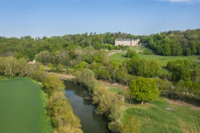
Courtanvaux Castle
No reviews yet
Have you flown here? Share your experience with other pilots.
+ Write the first reviewHistory
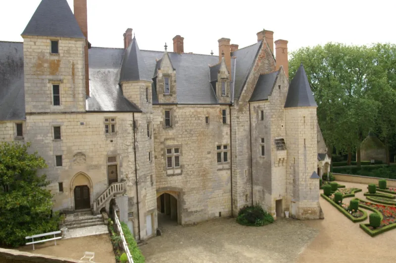
La première mention du fief de Courtanvaux date de 1332. La terre de Courtanvaux n’est alors qu’un tout petit fief dépendant de la seigneurie de Vancé, relevant elle-même du Vendômois. Le premier seigneur connu de Courtanvaux apparaît en 1351. Il s’agit de Michel de Doucelles. Son fils Michel II lui succède. S’ensuivent Jean Le Tort et sa femme Jeanne Asselin, puis, à partir de 1455, Jacques Berziau, peut-être neveu par alliance, qui rachète en 1459 la part de sa cohéritière Marie, veuve de Jean Cullier, devenant ainsi seigneur de Courtanvaux à part entière. Le château de Courtanvaux reste ensuite dans la même famille, se transmettant par héritage ou par mariage, jusqu’à son acquisition par la commune de Bessé-sur-Braye en 1978. L’acquisition de Courtanvaux par Jacques Berziau fait entrer le domaine dans une famille proche du pouvoir et lui donne dès lors une dimension nouvelle, qui ne fera que prendre de l’ampleur au cours des siècles suivants grâce aux figures illustres qui le possèderont.
Map and restricted areas
Open in the main mapRestricted zones
Nearby aerodromes
Open aerodromes within 25 km of the spot, heliports included, with their distance and direction from the spot. Near an aerodrome, drone flying is prohibited or height-limited: check the UAS zones map.
No known open aerodrome within 25 km.
Aviation weather (METAR and TAF)
LFRM – Le Mans-Arnage Airport MVFR
METAR
METAR LFRM 171330Z AUTO 21012KT 170V240 9999 BKN030 BKN036 OVC060 16/11 Q0994
- Wind
- 210°, 22 km/h
- Visibility
- 10 km or more
- Clouds
- Broken (5-7/8) at 3,000 ft (910 m) ; Broken (5-7/8) at 3,600 ft (1100 m) ; Overcast (8/8) at 6,000 ft (1830 m)
- Temperature
- 16 °C, dew point 11 °C
- QNH
- 994 hPa
- Flight category
- MVFR: ceiling 1,000–3,000 ft or visibility 3–5 mi
TAF
Weather and Kp index
| Day | Weather | Temp. min. / max. | Wind | Rain | Max Kp |
|---|---|---|---|---|---|
| Tue 17 Nov | Cloudy | 11° / 15° | 33 km/h SW | 6.1 mm | 5 |
| Wed 18 Nov | Showers | 10° / 14° | 33 km/h SW | 7.5 mm | 5 |
| Thu 19 Nov | Showers | 9° / 13° | 33 km/h SW | 4.5 mm | 3 |
| Fri 20 Nov | Light rain | 9° / 13° | 27 km/h SW | 1.2 mm | 3 |
| Sat 21 Nov | Cloudy | 7° / 11° | 21 km/h W | – | – |
| Sun 22 Nov | Rain | 8° / 12° | 26 km/h SW | 13 mm | – |
| Mon 23 Nov | Fair | 5° / 12° | 21 km/h W | 0.1 mm | – |
Hour by hour: Tuesday 17 November
| Time | Weather | Temp. | Wind | Rain | Clouds | Kp |
|---|---|---|---|---|---|---|
| 15:00 | Cloudy | 15° | 33 km/h SW | – | 88 % | 4 |
| 16:00 | Cloudy | 15° | 33 km/h SW | – | 98 % | 4 |
| 17:00 | Heavy rain | 14° | 32 km/h SW | 1.0 mm | 99 % | 4 |
| 18:00 | Heavy rain | 12° | 31 km/h SW | 2.1 mm | 100 % | 4 |
| 19:00 | Rain | 11° | 30 km/h SW | 0.5 mm | 100 % | 5 |
| 20:00 | Heavy rain | 12° | 33 km/h SW | 2.5 mm | 100 % | 5 |
| 21:00 | Cloudy | 12° | 32 km/h SW | – | 100 % | 5 |
| 22:00 | Partly cloudy | 12° | 29 km/h SW | – | 59 % | 5 |
Hour by hour: Wednesday 18 November
| Time | Weather | Temp. | Wind | Rain | Clouds | Kp |
|---|---|---|---|---|---|---|
| 06:00 | Cloudy | 10° | 25 km/h SW | – | 90 % | 4 |
| 07:00 | Cloudy | 10° | 25 km/h SW | – | 90 % | 4 |
| 08:00 | Cloudy | 10° | 26 km/h SW | – | 98 % | 4 |
| 09:00 | Partly cloudy | 11° | 26 km/h SW | – | 66 % | 4 |
| 10:00 | Fair | 11° | 24 km/h SW | – | 34 % | 4 |
| 11:00 | Fair | 12° | 28 km/h SW | – | 25 % | 4 |
| 12:00 | Showers | 13° | 33 km/h SW | 0.1 mm | 26 % | 4 |
| 13:00 | Showers | 14° | 32 km/h W | 0.1 mm | 32 % | 3 |
| 14:00 | Fair | 14° | 31 km/h SW | – | 24 % | 3 |
| 15:00 | Fair | 14° | 26 km/h SW | – | 19 % | 3 |
| 16:00 | Fair | 13° | 26 km/h SW | – | 23 % | 3 |
| 17:00 | Partly cloudy | 12° | 22 km/h SW | – | 61 % | 3 |
| 18:00 | Cloudy | 11° | 20 km/h SW | – | 98 % | 3 |
| 19:00 | Rain | 11° | 21 km/h SW | 0.8 mm | 100 % | 2 |
| 20:00 | Heavy rain | 11° | 23 km/h SW | 1.1 mm | 100 % | 2 |
| 21:00 | Heavy rain | 11° | 23 km/h S | 1.6 mm | 100 % | 2 |
| 22:00 | Heavy rain | 11° | 24 km/h S | 2.3 mm | 100 % | 2 |
Sunrise and sunset
| Day | Dawn | Sunrise | Golden hour | Sunset | Dusk | Day length |
|---|---|---|---|---|---|---|
| Tue 17 Nov | 07:32 | 08:06 | 08:06–08:54 · 16:30–17:18 | 17:18 | 17:52 | 9 h 12 |
| Wed 18 Nov | 07:33 | 08:07 | 08:07–08:56 · 16:28–17:17 | 17:17 | 17:51 | 9 h 09 |
| Thu 19 Nov | 07:35 | 08:09 | 08:09–08:58 · 16:27–17:16 | 17:16 | 17:50 | 9 h 07 |
| Fri 20 Nov | 07:36 | 08:10 | 08:10–08:59 · 16:26–17:15 | 17:15 | 17:49 | 9 h 04 |
| Sat 21 Nov | 07:37 | 08:12 | 08:12–09:01 · 16:25–17:14 | 17:14 | 17:48 | 9 h 02 |
| Sun 22 Nov | 07:39 | 08:13 | 08:13–09:03 · 16:24–17:13 | 17:13 | 17:48 | 9 h 00 |
| Mon 23 Nov | 07:40 | 08:15 | 08:15–09:04 · 16:23–17:12 | 17:12 | 17:47 | 8 h 57 |
Reviews (0)
Log in to review this spot. Log in · Create a free account
No reviews yet. Share yours!