

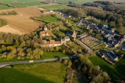
Radrets Castle
No reviews yet
Have you flown here? Share your experience with other pilots.
+ Write the first reviewHistory
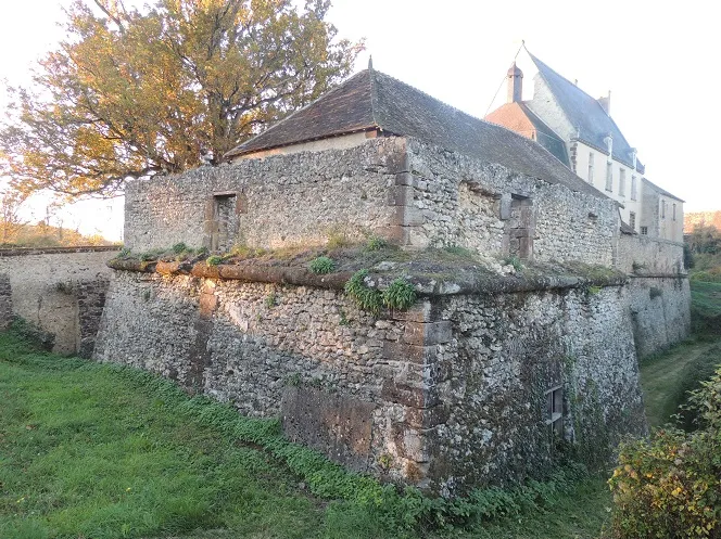
Le domaine est mentionné en 1444. Un vaste terre-plein au plan carré est entouré de larges fossés. D'importantes caponières de défense sont en saillie. Chaque avancée est percée d'une large meurtrière. L'ensemble du mur-talus et des caponières est entouré d'un gros cordon nobiliaire. Le corps de logis principal remonte aux 15e et 16e siècles. A l'arrière, une tour d'escalier carrée est en partie imbriquée dans la façade ouest. Une aile en retour d'équerre est plus récente. Au sud, une chapelle a été accolée, au 17e siècle, au pignon méridional. La grange se compose de deux bâtiments en équerre avec, à l'angle extérieur, une tour carrée en saillie sur les deux façades. Elle présente une charpente de châtaigner en carène de navire, certainement gothique. Une fuye carrée se trouve entre la ferme et le château.
Map and restricted areas
Open in the main mapRestricted zones
| Zone | Category | Limits | Conditions |
|---|---|---|---|
| Paris 9 | Zone réglementée | 2138 m above sea level → 3821 m above sea level | Vols interdits sauf lorsque the official document of the zone l'autorise explicitement ou avec l'accord du gestionnaire de la zone lorsqu'il est désigné par the official document of the zone |
Nearby aerodromes
Open aerodromes within 25 km of the spot, heliports included, with their distance and direction from the spot. Near an aerodrome, drone flying is prohibited or height-limited: check the UAS zones map.
No known open aerodrome within 25 km.
Aviation weather (METAR and TAF)
LFRM – Le Mans-Arnage Airport VFR
METAR
METAR LFRM 171400Z AUTO 21014KT 170V260 9999 SCT029 BKN037 OVC060 16/11 Q0993
- Wind
- 210°, 26 km/h
- Visibility
- 10 km or more
- Clouds
- Scattered (3-4/8) at 2,900 ft (880 m) ; Broken (5-7/8) at 3,700 ft (1130 m) ; Overcast (8/8) at 6,000 ft (1830 m)
- Temperature
- 16 °C, dew point 11 °C
- QNH
- 993 hPa
- Flight category
- VFR: ceiling > 3,000 ft and visibility > 5 mi
TAF
Weather and Kp index
Sunrise and sunset
| Day | Dawn | Sunrise | Golden hour | Sunset | Dusk | Day length |
|---|---|---|---|---|---|---|
| Tue 17 Nov | 07:32 | 08:06 | 08:06–08:54 · 16:29–17:17 | 17:17 | 17:51 | 9 h 11 |
| Wed 18 Nov | 07:33 | 08:07 | 08:07–08:56 · 16:27–17:16 | 17:16 | 17:50 | 9 h 09 |
| Thu 19 Nov | 07:35 | 08:09 | 08:09–08:58 · 16:26–17:15 | 17:15 | 17:49 | 9 h 06 |
| Fri 20 Nov | 07:36 | 08:10 | 08:10–08:59 · 16:25–17:14 | 17:14 | 17:49 | 9 h 04 |
| Sat 21 Nov | 07:37 | 08:12 | 08:12–09:01 · 16:24–17:13 | 17:13 | 17:48 | 9 h 01 |
| Sun 22 Nov | 07:39 | 08:13 | 08:13–09:03 · 16:23–17:12 | 17:12 | 17:47 | 8 h 59 |
| Mon 23 Nov | 07:40 | 08:14 | 08:14–09:04 · 16:22–17:12 | 17:12 | 17:46 | 8 h 57 |
Reviews (0)
Log in to review this spot. Log in · Create a free account
No reviews yet. Share yours!