

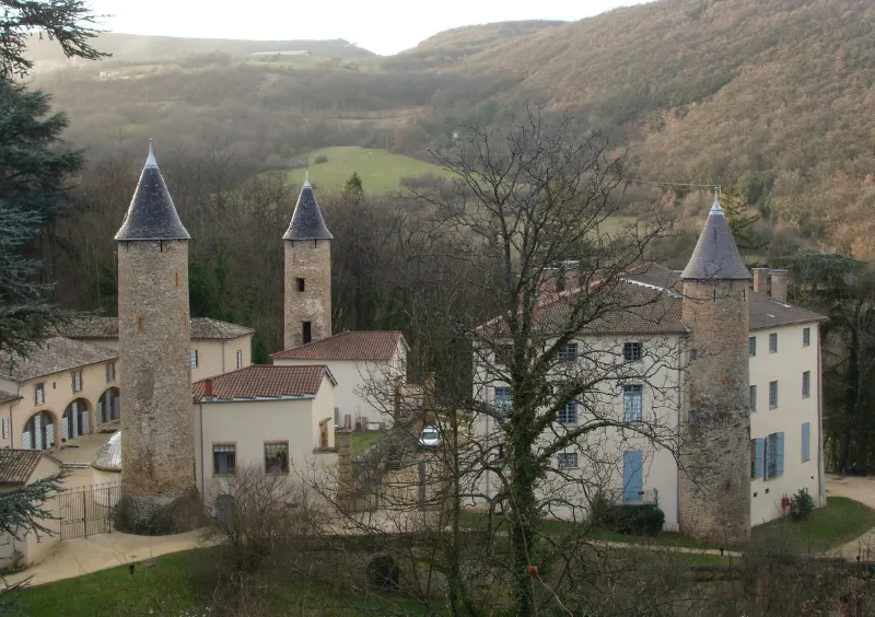
Curis-au-Mont-d'Or Estate known as Trolanderie Estate (also in the commune of Poleymieux-au-Mont-d'Or)
No reviews yet
Have you flown here? Share your experience with other pilots.
+ Write the first reviewHistory
Le domaine, connu dès 1270, est restauré par Jean-Antoine Morand en 1769. En 1794, la propriété s'étend sur 50ha. A partir de 1841, le domaine est revendu par parcelles à différents propriétaires, dont le comte Jean-Baptiste de Chazelles qui fait réaliser par l'architecte Curieux un plan du réseau hydraulique alimentant le bassin. En 1890, le projet d'aménagement du parc est confié à l'architecte paysagiste Luizet. En 1933, la société civile Ozanam de Lyon en devient propriétaire et y installe un collège avec internat. L'ensemble de la propriété est revendue en 1970. Dans les années 1980, le domaine est acquis par la SOGIMM qui y aménage des logements. ££Le domaine se compose d'un corps de logis pentagonal flanqué de trois tours circulaires, d'une chapelle, d'une orangerie et de dépendances, dans un parc boisé et paysager. Les trois tours marquent les angles du clos du Haut Moyen-Age. Trois phases principales d'édification se dégagent. Une première aux 14e-15e siècles avec la maison forte, les tours, un escalier à vis. Une seconde de 1769 à 1774 avec le réaménagement du château et l'aménagement des jardins. Enfin, une troisième phase en 1885-1890 correspondant à l'intervention de l'architecte Curieux, avec modification des communs, réalisation du salon marocain, de la chapelle et de l'orangerie, et réaménagement du parc. Les pièces ont conservé leur décor : parquets Versailles, cheminées du 19e, lambris, portes du 15e siècle, sol en mosaïque, boiseries peintes, toile marouflée, vitrail de style préraphaélite...
Map and restricted areas
Open in the main mapRestricted zones
| Zone | Category | Limits | Conditions |
|---|---|---|---|
| Tma Lyon |
Région de contrôle terminal | 762 m above sea level → 1372 m above sea level · 1067 m above sea level → 1372 m above sea level · 1067 m above sea level → 2297 m above sea level · 1372 m above sea level → 2297 m above sea level · 1529 m above sea level → 3821 m above sea level · 1834 m above sea level → 2907 m above sea level · 1834 m above sea level → 3821 m above sea level · 1834 m above sea level → 3821 m above sea level · 2138 m above sea level → 3821 m above sea level · 2138 m above sea level → 3821 m above sea level · 2138 m above sea level → 3821 m above sea level · 2443 m above sea level → 3821 m above sea level · 2443 m above sea level → 3821 m above sea level · 3053 m above sea level → 4735 m above sea level | Drone flights inside this zone are forbidden without the prior agreement of air traffic control |
| Zrt Lumiere Alpha | ZRT | FL 125 / FL 145 | SUP AIP 055/26 · Du jeudi 16 avril 2026 au mercredi 12 avril 2028 |
| Zrt Lumiere Bravo | ZRT | FL 145 / FL 175 | SUP AIP 055/26 · Du jeudi 16 avril 2026 au mercredi 12 avril 2028 |
| Zrt Lumiere High | ZRT | FL 175 / FL 195 | SUP AIP 055/26 · Du jeudi 16 avril 2026 au mercredi 12 avril 2028 |
Nearby aerodromes
Open aerodromes within 25 km of the spot, heliports included, with their distance and direction from the spot. Near an aerodrome, drone flying is prohibited or height-limited: check the UAS zones map.
| Aerodrome | Type | Distance | Elevation |
|---|---|---|---|
| Hôpital Edouard-Herriot Heliport | Heliport | 14 km S | 199 m |
| Villefranche-Tarare Airport | Aerodrome | 15 km NW | 328 m |
| Lyon-Bron Airport | Airport | 18 km SE | 201 m |
| Centre Hospitalier Heliport | Heliport | 18 km NW | 233 m |
| Lyon Brindas Airfield | Aerodrome | 19 km SW | 317 m |
Aviation weather (METAR and TAF)
LFLY – Lyon-Bron Airport VFR
METAR
METAR LFLY 171400Z AUTO 17016KT CAVOK 16/11 Q1001
- Wind
- 170°, 30 km/h
- Visibility
- 10 km or more
- Clouds
- –
- Temperature
- 16 °C, dew point 11 °C
- QNH
- 1001 hPa
- Flight category
- VFR: ceiling > 3,000 ft and visibility > 5 mi
TAF
TAF LFLY 170500Z 1706/1806 18015G25KT CAVOK TEMPO 1706/1712 18020G35KT 4500 RA FEW050TCU OVC055 BECMG 1800/1803 20012KT TEMPO 1800/1803 32015G25KT 4000 SHRA BKN045TCU
| Period (local time) | Change | Wind | Visibility | Weather | Clouds |
|---|---|---|---|---|---|
| 17/11 07:00 → 18/11 01:00 | Initial conditions | 180°, 28 km/h, gusts 46 km/h | 10 km or more | No significant weather | No significant cloud |
| 17/11 07:00 → 17/11 13:00 | Temporarily | 180°, 37 km/h, gusts 65 km/h | 4.5 km | Rain | Few (1-2/8) at 5,000 ft (1520 m) (towering cumulus) ; Overcast (8/8) at 5,500 ft (1680 m) |
| 18/11 01:00 → 18/11 07:00 | Becoming | 200°, 22 km/h | 10 km or more | No significant weather | No significant cloud |
| 18/11 01:00 → 18/11 04:00 | Temporarily | 320°, 28 km/h, gusts 46 km/h | 4.0 km | Showers of rain | Broken (5-7/8) at 4,500 ft (1370 m) (towering cumulus) |
Weather and Kp index
Sunrise and sunset
| Day | Dawn | Sunrise | Golden hour | Sunset | Dusk | Day length |
|---|---|---|---|---|---|---|
| Tue 17 Nov | 07:11 | 07:44 | 07:44–08:30 · 16:22–17:08 | 17:08 | 17:40 | 9 h 24 |
| Wed 18 Nov | 07:12 | 07:45 | 07:45–08:31 · 16:21–17:07 | 17:07 | 17:39 | 9 h 21 |
| Thu 19 Nov | 07:14 | 07:46 | 07:46–08:33 · 16:20–17:06 | 17:06 | 17:39 | 9 h 19 |
| Fri 20 Nov | 07:15 | 07:48 | 07:48–08:34 · 16:18–17:05 | 17:05 | 17:38 | 9 h 17 |
| Sat 21 Nov | 07:16 | 07:49 | 07:49–08:36 · 16:17–17:04 | 17:04 | 17:37 | 9 h 15 |
| Sun 22 Nov | 07:17 | 07:50 | 07:50–08:37 · 16:16–17:03 | 17:03 | 17:36 | 9 h 13 |
| Mon 23 Nov | 07:19 | 07:52 | 07:52–08:39 · 16:15–17:03 | 17:03 | 17:36 | 9 h 11 |
Nearby spots

Other tourist sites nearby
- Aqueduct Reservoirs of the Vallon d'Arche (remains)
- Gallo-Roman Settlement of La Grange du Bief
- Motte-and-Bailey
- Castle Mound
- Vaurenard Estate
- Gallo-Roman Aqueduct of the Gier, also known as the Mont-Pilat Aqueduct (also in the communes of Lyon, Sainte-Foy-lès-Lyon, Soucieu-en-Jarrest, Chaponost, Mornant)
Reviews (0)
Log in to review this spot. Log in · Create a free account
No reviews yet. Share yours!