

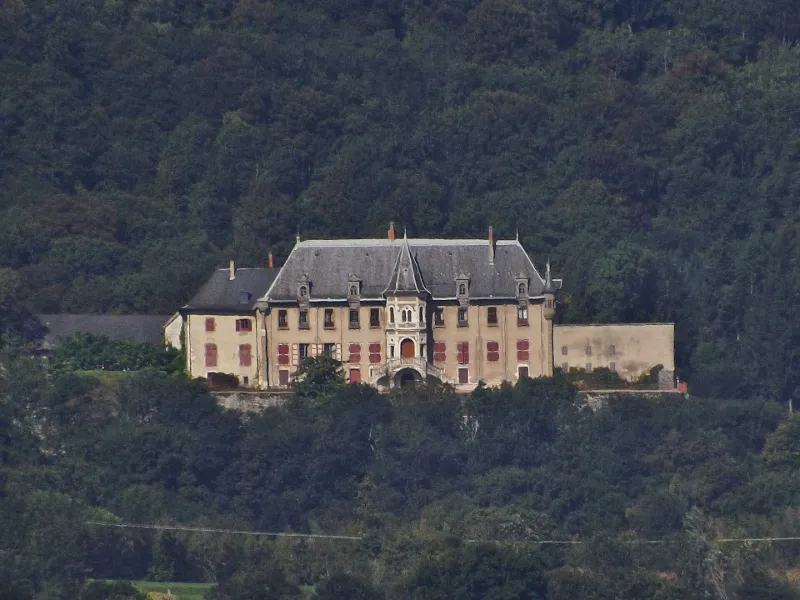
La Serraz Estate
No reviews yet
Have you flown here? Share your experience with other pilots.
+ Write the first reviewHistory
L'entrée dans la cour s'effectue par le seul vestige médiéval. Le bâtiment principal est en L et la cour est fermée par les communs et une grille. La façade principale est flanquée d'une tour en son centre. Sur celle-ci se trouve un décor à motif fleuri au niveau de la toiture, et les gouttières sont ornées de têtes de lions. La tour est décorée de colonnades, de chapiteaux, d'oculi. Elle ouvre sur les salles et permet d'accéder au rez-de-chaussée et au premier étage par un escalier à double volée. A l'entrée de la propriété se trouve la chapelle. La composition d'origine du domaine a été préservée jusqu'à nos jours.
Map and restricted areas
Open in the main mapRestricted zones
| Zone | Category | Limits | Conditions |
|---|---|---|---|
| Zrt/zdt Riviera | ZRT/ZDT | From about 14,950 m to about 16,750 m above sea level | SUP AIP 233/24 · Du 16 janvier 2025 au 13 janvier 2027 |
Nearby aerodromes
Open aerodromes within 25 km of the spot, heliports included, with their distance and direction from the spot. Near an aerodrome, drone flying is prohibited or height-limited: check the UAS zones map.
| Aerodrome | Type | Distance | Elevation |
|---|---|---|---|
| Chambéry-Savoie Airport | Airport | 2.7 km E | 237 m |
| Hôtel Ariana Heliport | Heliport | 6.9 km NE | 247 m |
| Centre Hospitalier Heliport | Heliport | 8.9 km SE | 319 m |
| Aérodrome de Chambéry Challes-les-Eaux | Aerodrome | 13 km SE | 297 m |
| Belley - Peyrieu Airfield | Aerodrome | 14 km NW | 225 m |
Aviation weather (METAR and TAF)
LFLB – Chambéry-Savoie Airport VFR
METAR
METAR LFLB 171400Z AUTO 21011KT 190V260 9999 BKN060 BKN070 OVC200 15/11 Q1002
- Wind
- 210°, 20 km/h
- Visibility
- 10 km or more
- Clouds
- Broken (5-7/8) at 6,000 ft (1830 m) ; Broken (5-7/8) at 7,000 ft (2130 m) ; Overcast (8/8) at 20,000 ft (6100 m)
- Temperature
- 15 °C, dew point 11 °C
- QNH
- 1002 hPa
- Flight category
- VFR: ceiling > 3,000 ft and visibility > 5 mi
TAF
Weather and Kp index
Sunrise and sunset
| Day | Dawn | Sunrise | Golden hour | Sunset | Dusk | Day length |
|---|---|---|---|---|---|---|
| Tue 17 Nov | 07:06 | 07:39 | 07:39–08:24 · 16:19–17:04 | 17:04 | 17:37 | 9 h 25 |
| Wed 18 Nov | 07:08 | 07:40 | 07:40–08:26 · 16:17–17:03 | 17:03 | 17:36 | 9 h 23 |
| Thu 19 Nov | 07:09 | 07:41 | 07:41–08:28 · 16:16–17:03 | 17:03 | 17:35 | 9 h 21 |
| Fri 20 Nov | 07:10 | 07:43 | 07:43–08:29 · 16:15–17:02 | 17:02 | 17:34 | 9 h 18 |
| Sat 21 Nov | 07:12 | 07:44 | 07:44–08:31 · 16:14–17:01 | 17:01 | 17:33 | 9 h 16 |
| Sun 22 Nov | 07:13 | 07:45 | 07:45–08:32 · 16:13–17:00 | 17:00 | 17:33 | 9 h 14 |
| Mon 23 Nov | 07:14 | 07:47 | 07:47–08:34 · 16:12–16:59 | 16:59 | 17:32 | 9 h 12 |
Reviews (0)
Log in to review this spot. Log in · Create a free account
No reviews yet. Share yours!