

Vix Site and Princely Tomb
No reviews yet
Have you flown here? Share your experience with other pilots.
+ Write the first reviewHistory
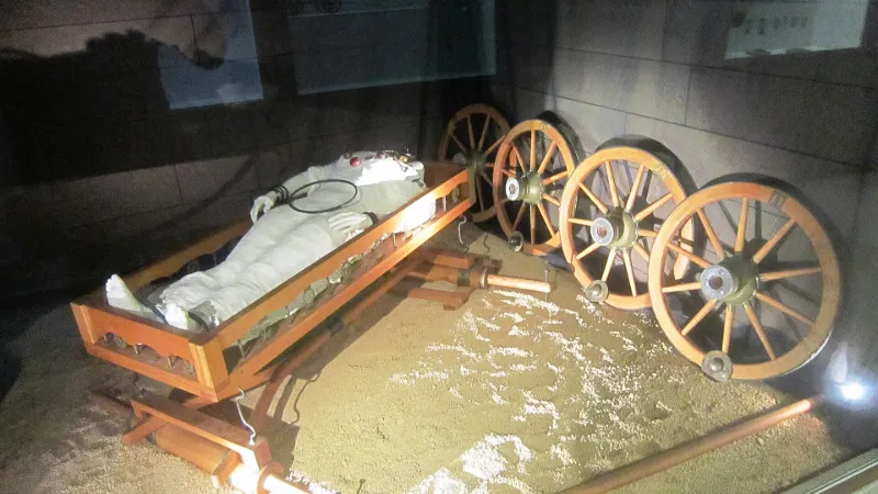
Antiquité Cette sépulture princière accompagnée d'un mobilier exceptionnel, dont un cratère de bronze datable des environs de 500 AC, est un témoignage majeur pour la connaissance du monde celte. Découverte au début des années 1950, la tombe en " caisson de bois " conservait les éléments d'un char à quatre roues, des bijoux dont un torque en or, de la vaisselle en métal, de la céramique grecque à motifs noirs sur fond rouge. Les restes du squelette ont permis d'identifier le corps d'une femme d'une trentaine d'années. Le tertre mesure dans les 38 mètres et le tumulus est entouré d'une couronne de pierre.
Map and restricted areas
Open in the main mapRestricted zones
| Zone | Category | Limits | Conditions |
|---|---|---|---|
| VIX (21) | Activité de loisirs | 0 m above ground level → 61 m above ground level · 0 m above ground level → 366 m above sea level | Flights reserved for members and guests of the club, under the terms set by the model-aircraft field manager |
| SETBA Secteur AUBE | Entrainement Militaire | 0 m above ground level → 15241 m above ground level | Pilotage de drones en vue directe : les aéronefs dont la masse est supérieure à 900 grammes sont soumis à notification préalable selon des modalités publiées sur le site www.ecologie.gouv.fr |
| Zrt Opal | ZRT | From about 14,950 m to about 16,750 m above sea level | SUP AIP 233/24 · Du 16 janvier 2025 au 13 janvier 2027 |
| Zrt Chatillon Sud | ZRT | From about 3,800 m to about 4,100 m above sea level | SUP AIP 053/26 · Du jeudi 16 avril 2026 au mercredi 12 avril 2028 |
| Zrt Chatillon Sud High | ZRT | From about 5,650 m to about 5,950 m above sea level | SUP AIP 053/26 · Du jeudi 16 avril 2026 au mercredi 12 avril 2028 |
Nearby aerodromes
Open aerodromes within 25 km of the spot, heliports included, with their distance and direction from the spot. Near an aerodrome, drone flying is prohibited or height-limited: check the UAS zones map.
| Aerodrome | Type | Distance | Elevation |
|---|---|---|---|
| Centre Hospitalier Heliport | Heliport | 5.3 km S | 241 m |
| Châtillon Sur Seine Airfield | Aerodrome | 7.8 km SE | 276 m |
| Bar Sur Seine Airfield | Aerodrome | 20 km NW | 286 m |
Aviation weather (METAR and TAF)
No METAR station within 50 km.
Weather and Kp index
| Day | Weather | Temp. min. / max. | Wind | Rain | Max Kp |
|---|---|---|---|---|---|
| Tue 17 Nov | Cloudy | 11° / 15° | 35 km/h SW | 1.7 mm | 5 |
| Wed 18 Nov | Showers | 10° / 13° | 30 km/h SW | 4.4 mm | 5 |
| Thu 19 Nov | Showers | 8° / 12° | 35 km/h W | 11 mm | 3 |
| Fri 20 Nov | Showers | 8° / 12° | 27 km/h SW | 5.7 mm | 3 |
| Sat 21 Nov | Cloudy | 7° / 10° | 23 km/h SW | 0.7 mm | – |
| Sun 22 Nov | Showers | 5° / 10° | 24 km/h W | 14 mm | – |
| Mon 23 Nov | Partly cloudy | 6° / 10° | 24 km/h SW | 3.1 mm | – |
Hour by hour: Tuesday 17 November
| Time | Weather | Temp. | Wind | Rain | Clouds | Kp |
|---|---|---|---|---|---|---|
| 15:00 | Cloudy | 15° | 28 km/h SW | – | 99 % | 4 |
| 16:00 | Cloudy | 14° | 24 km/h SW | – | 91 % | 4 |
| 17:00 | Cloudy | 14° | 26 km/h SW | – | 94 % | 4 |
| 18:00 | Partly cloudy | 14° | 27 km/h SW | – | 81 % | 4 |
| 19:00 | Cloudy | 13° | 29 km/h SW | – | 93 % | 5 |
| 20:00 | Showers | 14° | 31 km/h SW | 0.1 mm | 77 % | 5 |
| 21:00 | Rain | 12° | 32 km/h SW | 0.8 mm | 91 % | 5 |
| 22:00 | Light rain | 11° | 35 km/h SW | 0.2 mm | 98 % | 5 |
Hour by hour: Wednesday 18 November
| Time | Weather | Temp. | Wind | Rain | Clouds | Kp |
|---|---|---|---|---|---|---|
| 06:00 | Rain | 10° | 24 km/h SW | 0.7 mm | 99 % | 4 |
| 07:00 | Rain | 10° | 26 km/h SW | 0.5 mm | 100 % | 4 |
| 08:00 | Rain | 10° | 25 km/h SW | 0.5 mm | 100 % | 4 |
| 09:00 | Heavy rain | 10° | 27 km/h SW | 1.3 mm | 100 % | 4 |
| 10:00 | Light rain | 10° | 27 km/h SW | 0.2 mm | 99 % | 4 |
| 11:00 | Partly cloudy | 11° | 29 km/h SW | – | 60 % | 4 |
| 12:00 | Partly cloudy | 12° | 29 km/h SW | – | 46 % | 4 |
| 13:00 | Showers | 13° | 29 km/h SW | 0.1 mm | 14 % | 3 |
| 14:00 | Cloudy | 13° | 30 km/h SW | – | 98 % | 3 |
| 15:00 | Showers | 13° | 26 km/h SW | 0.4 mm | 50 % | 3 |
| 16:00 | Showers | 11° | 24 km/h SW | 0.2 mm | 38 % | 3 |
| 17:00 | Fair | 10° | 22 km/h SW | – | 21 % | 3 |
| 18:00 | Fair | 10° | 22 km/h SW | – | 13 % | 3 |
| 19:00 | Fair | 10° | 20 km/h SW | – | 27 % | 2 |
| 20:00 | Partly cloudy | 10° | 19 km/h SW | – | 80 % | 2 |
| 21:00 | Cloudy | 10° | 19 km/h SW | – | 97 % | 2 |
| 22:00 | Cloudy | 10° | 18 km/h SW | – | 100 % | 2 |
Sunrise and sunset
| Day | Dawn | Sunrise | Golden hour | Sunset | Dusk | Day length |
|---|---|---|---|---|---|---|
| Tue 17 Nov | 07:17 | 07:51 | 07:51–08:40 · 16:14–17:03 | 17:03 | 17:37 | 9 h 11 |
| Wed 18 Nov | 07:18 | 07:52 | 07:52–08:41 · 16:13–17:02 | 17:02 | 17:36 | 9 h 09 |
| Thu 19 Nov | 07:20 | 07:54 | 07:54–08:43 · 16:12–17:01 | 17:01 | 17:35 | 9 h 06 |
| Fri 20 Nov | 07:21 | 07:55 | 07:55–08:45 · 16:10–17:00 | 17:00 | 17:34 | 9 h 04 |
| Sat 21 Nov | 07:22 | 07:57 | 07:57–08:46 · 16:09–16:59 | 16:59 | 17:33 | 9 h 02 |
| Sun 22 Nov | 07:24 | 07:58 | 07:58–08:48 · 16:08–16:58 | 16:58 | 17:32 | 8 h 59 |
| Mon 23 Nov | 07:25 | 08:00 | 08:00–08:49 · 16:07–16:57 | 16:57 | 17:31 | 8 h 57 |

Reviews (0)
Log in to review this spot. Log in · Create a free account
No reviews yet. Share yours!