

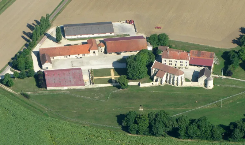
Former Templar Commandery of Epailly
No reviews yet
Have you flown here? Share your experience with other pilots.
+ Write the first reviewHistory
13e siècle ; 2e moitié 14e siècle ; milieu 19e siècle La commanderie est conçue pour les Templiers, en 1209. Au début du 14ème siècle, leurs possessions reviennent aux Hospitaliers et le prieur de Champagne y installe sa demeure qu'il fortifie par la suite. La chapelle ainsi qu'une cave utilisée comme cellier et les restes des murs de fortification avec une tour d'angle sont les seuls témoins de l'époque des Templiers.£La chapelle, édifiée au 13ème siècle, a perdu une partie de ses voûtes. Elle se compose d'un vaisseau, couvert de voûtes sexpartites retombant sur des colonnettes à chapiteaux, soutenus par des culs-de-lampes. Le cellier est formé de deux vaisseaux de trois travées sur croisée d'ogives retombant sur des piliers cylindriques sans chapiteaux. Des bâtiments édifiés autour d'une basse-cour et cernés par un mur ainsi que des fossés sont l'œuvre des Hospitaliers aux 15ème et 17ème siècles. Il s'agit de deux granges ainsi que d'un colombier.
Map and restricted areas
Open in the main mapRestricted zones
| Zone | Category | Limits | Conditions |
|---|---|---|---|
| Chaumont Juvancourt | Zone réglementée | 305 m above ground level → 1992 m above sea level | Vols interdits sauf lorsque the official document of the zone l'autorise explicitement ou avec l'accord du gestionnaire de la zone lorsqu'il est désigné par the official document of the zone |
| Zrt Opal | ZRT | From about 14,950 m to about 16,750 m above sea level | SUP AIP 233/24 · Du 16 janvier 2025 au 13 janvier 2027 |
Nearby aerodromes
Open aerodromes within 25 km of the spot, heliports included, with their distance and direction from the spot. Near an aerodrome, drone flying is prohibited or height-limited: check the UAS zones map.
| Aerodrome | Type | Distance | Elevation |
|---|---|---|---|
| Châtillon Sur Seine Airfield | Aerodrome | 14 km SW | 276 m |
| Centre Hospitalier Heliport | Heliport | 14 km SW | 241 m |
| Aérodrome de Juvancourt | Aerodrome | 22 km N | 349 m |
Aviation weather (METAR and TAF)
No METAR station within 50 km.
Weather and Kp index
| Day | Weather | Temp. min. / max. | Wind | Rain | Max Kp |
|---|---|---|---|---|---|
| Tue 17 Nov | Cloudy | 11° / 15° | 35 km/h SW | 2.3 mm | 5 |
| Wed 18 Nov | Showers | 9° / 12° | 30 km/h SW | 5.3 mm | 5 |
| Thu 19 Nov | Showers | 8° / 12° | 35 km/h SW | 12 mm | 3 |
| Fri 20 Nov | Showers | 8° / 11° | 27 km/h SW | 6.2 mm | 3 |
| Sat 21 Nov | Cloudy | 6° / 10° | 23 km/h SW | 1.2 mm | – |
| Sun 22 Nov | Showers | 5° / 10° | 25 km/h SW | 13 mm | – |
| Mon 23 Nov | Partly cloudy | 6° / 10° | 23 km/h SW | 3.1 mm | – |
Hour by hour: Tuesday 17 November
| Time | Weather | Temp. | Wind | Rain | Clouds | Kp |
|---|---|---|---|---|---|---|
| 15:00 | Cloudy | 15° | 28 km/h SW | – | 98 % | 4 |
| 16:00 | Cloudy | 14° | 22 km/h SW | – | 97 % | 4 |
| 17:00 | Cloudy | 14° | 25 km/h SW | – | 95 % | 4 |
| 18:00 | Partly cloudy | 14° | 26 km/h SW | – | 46 % | 4 |
| 19:00 | Cloudy | 13° | 28 km/h SW | – | 91 % | 5 |
| 20:00 | Showers | 13° | 30 km/h SW | 0.1 mm | 86 % | 5 |
| 21:00 | Heavy rain | 12° | 32 km/h SW | 1.2 mm | 98 % | 5 |
| 22:00 | Light rain | 11° | 35 km/h SW | 0.3 mm | 98 % | 5 |
Hour by hour: Wednesday 18 November
| Time | Weather | Temp. | Wind | Rain | Clouds | Kp |
|---|---|---|---|---|---|---|
| 06:00 | Rain | 10° | 24 km/h SW | 0.6 mm | 98 % | 4 |
| 07:00 | Rain | 10° | 26 km/h SW | 0.6 mm | 100 % | 4 |
| 08:00 | Rain | 10° | 24 km/h SW | 0.6 mm | 100 % | 4 |
| 09:00 | Rain | 10° | 26 km/h SW | 0.8 mm | 98 % | 4 |
| 10:00 | Heavy rain | 10° | 27 km/h SW | 1.1 mm | 99 % | 4 |
| 11:00 | Cloudy | 10° | 29 km/h SW | – | 88 % | 4 |
| 12:00 | Showers | 12° | 28 km/h SW | 0.1 mm | 56 % | 4 |
| 13:00 | Showers | 12° | 29 km/h SW | 0.2 mm | 16 % | 3 |
| 14:00 | Light rain | 12° | 29 km/h SW | 0.2 mm | 97 % | 3 |
| 15:00 | Showers | 12° | 27 km/h SW | 0.4 mm | 39 % | 3 |
| 16:00 | Showers | 11° | 26 km/h SW | 0.2 mm | 48 % | 3 |
| 17:00 | Fair | 10° | 22 km/h SW | – | 27 % | 3 |
| 18:00 | Fair | 10° | 21 km/h SW | – | 16 % | 3 |
| 19:00 | Fair | 10° | 21 km/h SW | – | 21 % | 2 |
| 20:00 | Partly cloudy | 10° | 18 km/h SW | – | 75 % | 2 |
| 21:00 | Cloudy | 9° | 18 km/h SW | – | 97 % | 2 |
| 22:00 | Cloudy | 10° | 17 km/h SW | – | 98 % | 2 |
Sunrise and sunset
| Day | Dawn | Sunrise | Golden hour | Sunset | Dusk | Day length |
|---|---|---|---|---|---|---|
| Tue 17 Nov | 07:16 | 07:50 | 07:50–08:39 · 16:13–17:02 | 17:02 | 17:36 | 9 h 11 |
| Wed 18 Nov | 07:18 | 07:52 | 07:52–08:41 · 16:12–17:01 | 17:01 | 17:35 | 9 h 09 |
| Thu 19 Nov | 07:19 | 07:53 | 07:53–08:42 · 16:11–17:00 | 17:00 | 17:34 | 9 h 06 |
| Fri 20 Nov | 07:20 | 07:55 | 07:55–08:44 · 16:10–16:59 | 16:59 | 17:33 | 9 h 04 |
| Sat 21 Nov | 07:22 | 07:56 | 07:56–08:46 · 16:08–16:58 | 16:58 | 17:32 | 9 h 01 |
| Sun 22 Nov | 07:23 | 07:57 | 07:57–08:47 · 16:07–16:57 | 16:57 | 17:31 | 8 h 59 |
| Mon 23 Nov | 07:24 | 07:59 | 07:59–08:49 · 16:06–16:56 | 16:56 | 17:31 | 8 h 57 |
Reviews (0)
Log in to review this spot. Log in · Create a free account
No reviews yet. Share yours!