

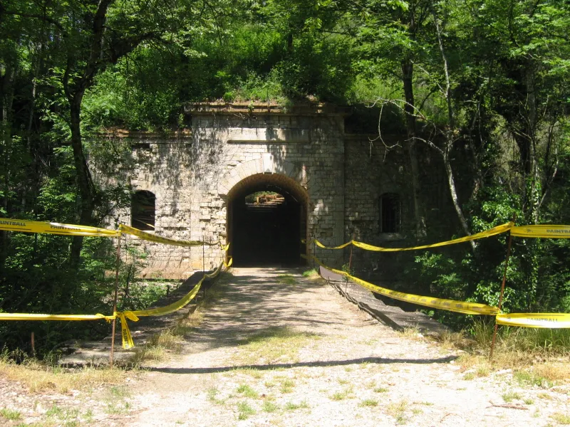
Asnières Fort, known as Burnt Fort
No reviews yet
Have you flown here? Share your experience with other pilots.
+ Write the first reviewHistory
4e quart 19e siècle Ce fort de ceinture, construit sur une hauteur de 330 mètres, était destiné à subir le choc frontal de l'armée prussienne. Le tir de ses canons pouvait faire barrage, croisés avec celui de la batterie annexe de Norges. Son plan polygonal à batterie basse, était flanqué de deux ailerons à chaque saillant, pour la défense des fossés. Une caponnière de front de tête, deux coffres de courtine de part et d'autre de l'entrée, défendaient l'accès menant à un système de pont, modèle unique autour de Dijon. Ce pont, de type Truck, était constitué d'un plateau roulant sur deux rails placés transversalement devant la porte d'entrée. Son effacement sous le poste de garde dégageait une fosse profonde créant une brèche sous le porche. La façade de gorge et la courtine sont conservées, portant la date de 1876-1877 au-dessus du porche d'entrée. L'armement, réparti pour le flanquement, les huit casemates et les remparts, est de quarante-quatre pièces d'artillerie. Le service de l'artillerie et de l'infanterie était assuré par 735 hommes. Les deux citernes avaient une capacité totale de 600m², permettant de soutenir un siège de six mois. Le 8 septembre 1944, les Allemands font sauter le dépôt de munitions stocké dans le fort, le détruisant à 90%.
Map and restricted areas
Open in the main mapRestricted zones
| Zone | Category | Limits | Conditions |
|---|---|---|---|
| Zrt Opal | ZRT | From about 14,950 m to about 16,750 m above sea level | SUP AIP 233/24 · Du 16 janvier 2025 au 13 janvier 2027 |
Nearby aerodromes
Open aerodromes within 25 km of the spot, heliports included, with their distance and direction from the spot. Near an aerodrome, drone flying is prohibited or height-limited: check the UAS zones map.
| Aerodrome | Type | Distance | Elevation |
|---|---|---|---|
| Dijon Darois Airfield | Aerodrome | 7.8 km W | 483 m |
| Centre Hospitalier Régional Heliport | Heliport | 8.8 km S | 238 m |
| Dijon-Bourgogne Airport | Airport | 14 km S | 221 m |
| Til Châtel Airfield | Aerodrome | 21 km NE | 286 m |
| Centre d'Etude du C.E.A. Heliport | Heliport | 24 km NW | 491 m |
Aviation weather (METAR and TAF)
LFSD – Dijon-Bourgogne Airport VFR
METAR
METAR LFSD 171330Z AUTO 23014KT 9999 SCT039 BKN045 BKN055 18/11 Q0998
- Wind
- 230°, 26 km/h
- Visibility
- 10 km or more
- Clouds
- Scattered (3-4/8) at 3,900 ft (1190 m) ; Broken (5-7/8) at 4,500 ft (1370 m) ; Broken (5-7/8) at 5,500 ft (1680 m)
- Temperature
- 18 °C, dew point 11 °C
- QNH
- 998 hPa
- Flight category
- VFR: ceiling > 3,000 ft and visibility > 5 mi
TAF
Weather and Kp index
| Day | Weather | Temp. min. / max. | Wind | Rain | Max Kp |
|---|---|---|---|---|---|
| Tue 17 Nov | Partly cloudy | 11° / 16° | 29 km/h SW | 2.5 mm | 5 |
| Wed 18 Nov | Showers | 9° / 13° | 30 km/h W | 1.6 mm | 5 |
| Thu 19 Nov | Showers | 9° / 12° | 29 km/h SW | 12 mm | 3 |
| Fri 20 Nov | Light rain | 8° / 12° | 23 km/h SW | 4.1 mm | 3 |
| Sat 21 Nov | Partly cloudy | 6° / 11° | 16 km/h SW | 0.2 mm | – |
| Sun 22 Nov | Fair | 5° / 10° | 19 km/h SW | 11 mm | – |
| Mon 23 Nov | Fair | 6° / 11° | 20 km/h SW | 1.2 mm | – |
Hour by hour: Tuesday 17 November
| Time | Weather | Temp. | Wind | Rain | Clouds | Kp |
|---|---|---|---|---|---|---|
| 15:00 | Partly cloudy | 16° | 25 km/h SW | – | 82 % | 4 |
| 16:00 | Partly cloudy | 15° | 21 km/h SW | – | 62 % | 4 |
| 17:00 | Partly cloudy | 14° | 24 km/h SW | – | 58 % | 4 |
| 18:00 | Fair | 14° | 23 km/h SW | – | 32 % | 4 |
| 19:00 | Partly cloudy | 13° | 25 km/h SW | – | 41 % | 5 |
| 20:00 | Fair | 13° | 26 km/h SW | – | 23 % | 5 |
| 21:00 | Heavy rain | 12° | 27 km/h SW | 1.7 mm | 100 % | 5 |
| 22:00 | Rain | 11° | 28 km/h SW | 0.6 mm | 100 % | 5 |
Hour by hour: Wednesday 18 November
| Time | Weather | Temp. | Wind | Rain | Clouds | Kp |
|---|---|---|---|---|---|---|
| 06:00 | Partly cloudy | 10° | 22 km/h SW | – | 72 % | 4 |
| 07:00 | Showers | 10° | 23 km/h SW | 0.1 mm | 67 % | 4 |
| 08:00 | Partly cloudy | 10° | 23 km/h SW | – | 78 % | 4 |
| 09:00 | Cloudy | 11° | 24 km/h SW | – | 97 % | 4 |
| 10:00 | Showers | 12° | 25 km/h SW | 0.3 mm | 69 % | 4 |
| 11:00 | Showers | 12° | 27 km/h SW | 0.1 mm | 47 % | 4 |
| 12:00 | Partly cloudy | 12° | 30 km/h W | – | 56 % | 4 |
| 13:00 | Showers | 13° | 30 km/h W | 0.3 mm | 37 % | 3 |
| 14:00 | Showers | 12° | 30 km/h W | 0.4 mm | 65 % | 3 |
| 15:00 | Showers | 12° | 28 km/h SW | 0.2 mm | 43 % | 3 |
| 16:00 | Fair | 12° | 25 km/h SW | – | 18 % | 3 |
| 17:00 | Clear sky | 11° | 22 km/h SW | – | 8 % | 3 |
| 18:00 | Clear sky | 11° | 19 km/h SW | – | 12 % | 3 |
| 19:00 | Partly cloudy | 10° | 18 km/h SW | – | 73 % | 2 |
| 20:00 | Partly cloudy | 10° | 15 km/h SW | – | 84 % | 2 |
| 21:00 | Cloudy | 9° | 16 km/h S | – | 93 % | 2 |
| 22:00 | Cloudy | 9° | 17 km/h S | – | 99 % | 2 |
Sunrise and sunset
| Day | Dawn | Sunrise | Golden hour | Sunset | Dusk | Day length |
|---|---|---|---|---|---|---|
| Tue 17 Nov | 07:14 | 07:47 | 07:47–08:35 · 16:14–17:02 | 17:02 | 17:36 | 9 h 15 |
| Wed 18 Nov | 07:15 | 07:49 | 07:49–08:37 · 16:13–17:01 | 17:01 | 17:35 | 9 h 12 |
| Thu 19 Nov | 07:16 | 07:50 | 07:50–08:38 · 16:12–17:00 | 17:00 | 17:34 | 9 h 10 |
| Fri 20 Nov | 07:18 | 07:52 | 07:52–08:40 · 16:11–16:59 | 16:59 | 17:33 | 9 h 07 |
| Sat 21 Nov | 07:19 | 07:53 | 07:53–08:42 · 16:10–16:58 | 16:58 | 17:32 | 9 h 05 |
| Sun 22 Nov | 07:20 | 07:54 | 07:54–08:43 · 16:09–16:57 | 16:57 | 17:31 | 9 h 03 |
| Mon 23 Nov | 07:22 | 07:56 | 07:56–08:45 · 16:07–16:57 | 16:57 | 17:31 | 9 h 00 |



Reviews (0)
Log in to review this spot. Log in · Create a free account
No reviews yet. Share yours!