

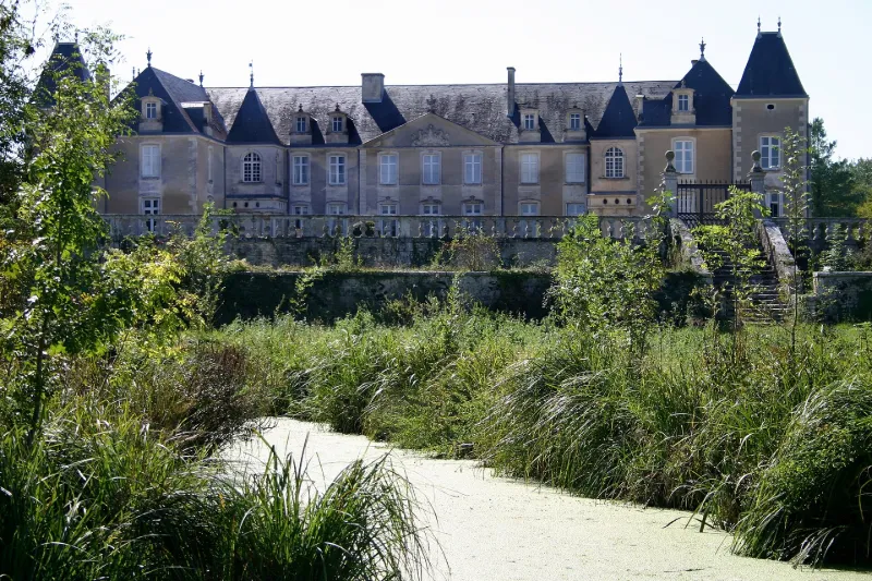
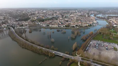
Panloy Castle
No reviews yet
Have you flown here? Share your experience with other pilots.
+ Write the first reviewHistory
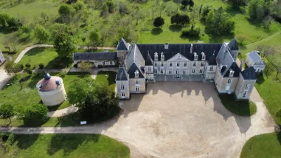
17e siècle ; 18e siècle ; 19e siècle L'édifice primitif, dû sans doute à une Renaissance tardive (1555-1620), dont le seul témoignage visible se trouve dans les petits pavillons d'angles à colonnettes, a été très modifié au cours des siècles suivants. Une importante restauration est décidée au 18e siècle, et confiée à l'architecte Barbier de Noisy. En 1812, un incendie oblige à reconstruire l'aile droite. Le plan du château est en forme de U, à un étage. La façade principale, au nord, se compose d'un corps de logis central dont les six fenêtres de l'avancée portent un décor. Elles sont surmontées d'agrafes sculptées de feuilles d'acanthe stylisées. Un fronton triangulaire, orné au 19e siècle de lions soutenant un blason, couronne cet avant-corps central. Il porte une urne funéraire en acrotère. Les lucarnes ont été modifiées au 19e siècle, lors de la suppression du toit à la Mansart. Les deux petits pavillons d'angle témoignent d'une Renaissance tardive, au moins pour leur étage inférieur en galerie, celle-ci se prolongeant peut-être primitivement le long de la façade postérieure sud. Le domaine conserve un pigeonnier daté de 1620, comportant trois mille boulins ronds en terre cuite.
Map and restricted areas
Open in the main mapRestricted zones
| Zone | Category | Limits | Conditions |
|---|---|---|---|
| Tma la Rochelle |
Région de contrôle terminal | 610 m above sea level → 914 m above sea level · 610 m above sea level → 914 m above sea level · 610 m above sea level → 3821 m above sea level · 610 m above sea level → 3821 m above sea level · 914 m above sea level → 3821 m above sea level | Drone flights inside this zone are forbidden without the prior agreement of air traffic control |
| Cognac | Zone réglementée | 914 m above sea level → 1219 m above sea level | Vols interdits sauf lorsque the official document of the zone l'autorise explicitement ou avec l'accord du gestionnaire de la zone lorsqu'il est désigné par the official document of the zone |
| Cognac | Zone réglementée | 1219 m above sea level → 2297 m above sea level | Vols interdits sauf lorsque the official document of the zone l'autorise explicitement ou avec l'accord du gestionnaire de la zone lorsqu'il est désigné par the official document of the zone |
| Cognac | Zone réglementée | 1529 m above sea level → 6259 m above sea level | Vols interdits sauf lorsque the official document of the zone l'autorise explicitement ou avec l'accord du gestionnaire de la zone lorsqu'il est désigné par the official document of the zone |
Nearby aerodromes
Open aerodromes within 25 km of the spot, heliports included, with their distance and direction from the spot. Near an aerodrome, drone flying is prohibited or height-limited: check the UAS zones map.
| Aerodrome | Type | Distance | Elevation |
|---|---|---|---|
| Centre Hospitalier de Saintongues Heliport | Heliport | 11 km S | 41 m |
| Saintes Thénac Airfield | Aerodrome | 16 km S | 36 m |
| St Jean d'Angély Airfield | Aerodrome | 19 km NE | 75 m |
| Rochefort-Saint-Agnant (BA 721) Airport | Airport | 23 km W | 18 m |
Aviation weather (METAR and TAF)
LFBG – Cognac-Châteaubernard (BA 709) Air Base MVFR
METAR
METAR LFBG 171400Z AUTO 22016KT 9999 BKN023 BKN031 BKN082 18/13 Q1000 TEMPO 4000 SHRA SCT030TCU BECMG 25018G28KT
- Wind
- 220°, 30 km/h
- Visibility
- 10 km or more
- Clouds
- Broken (5-7/8) at 2,300 ft (700 m) ; Broken (5-7/8) at 3,100 ft (940 m) ; Broken (5-7/8) at 8,200 ft (2500 m)
- Temperature
- 18 °C, dew point 13 °C
- QNH
- 1000 hPa
- Flight category
- MVFR: ceiling 1,000–3,000 ft or visibility 3–5 mi
TAF
TAF LFBG 170800Z 1709/1809 25018G28KT 9999 BKN020 PROB30 TEMPO 1715/1718 4000 SHRA SCT030TCU TEMPO 1719/1723 24025G35KT 4000 SHRA BKN030TCU PROB40 TEMPO 1720/1722 3000 TSRA BKN025CB TEMPO 1806/1809 4000 SHRA BKN020TCU
| Period (local time) | Change | Wind | Visibility | Weather | Clouds |
|---|---|---|---|---|---|
| 17/11 10:00 → 18/11 10:00 | Initial conditions | 250°, 33 km/h, gusts 52 km/h | 10 km or more | Broken (5-7/8) at 2,000 ft (610 m) | |
| 17/11 16:00 → 17/11 19:00 | Temporarily, probability 30% | 4.0 km | Showers of rain | Scattered (3-4/8) at 3,000 ft (910 m) (towering cumulus) | |
| 17/11 20:00 → 18/11 00:00 | Temporarily | 240°, 46 km/h, gusts 65 km/h | 4.0 km | Showers of rain | Broken (5-7/8) at 3,000 ft (910 m) (towering cumulus) |
| 17/11 21:00 → 17/11 23:00 | Temporarily, probability 40% | 3.0 km | Thunderstorm rain | Broken (5-7/8) at 2,500 ft (760 m) (cumulonimbus) | |
| 18/11 07:00 → 18/11 10:00 | Temporarily | 4.0 km | Showers of rain | Broken (5-7/8) at 2,000 ft (610 m) (towering cumulus) |
Weather and Kp index
Sunrise and sunset
| Day | Dawn | Sunrise | Golden hour | Sunset | Dusk | Day length |
|---|---|---|---|---|---|---|
| Tue 17 Nov | 07:33 | 08:06 | 08:06–08:52 · 16:44–17:30 | 17:30 | 18:02 | 9 h 24 |
| Wed 18 Nov | 07:34 | 08:07 | 08:07–08:53 · 16:43–17:29 | 17:29 | 18:01 | 9 h 22 |
| Thu 19 Nov | 07:36 | 08:08 | 08:08–08:55 · 16:42–17:28 | 17:28 | 18:01 | 9 h 19 |
| Fri 20 Nov | 07:37 | 08:10 | 08:10–08:56 · 16:41–17:27 | 17:27 | 18:00 | 9 h 17 |
| Sat 21 Nov | 07:38 | 08:11 | 08:11–08:58 · 16:40–17:26 | 17:26 | 17:59 | 9 h 15 |
| Sun 22 Nov | 07:39 | 08:12 | 08:12–08:59 · 16:39–17:25 | 17:25 | 17:58 | 9 h 13 |
| Mon 23 Nov | 07:41 | 08:14 | 08:14–09:01 · 16:38–17:25 | 17:25 | 17:58 | 9 h 11 |
Reviews (0)
Log in to review this spot. Log in · Create a free account
No reviews yet. Share yours!