

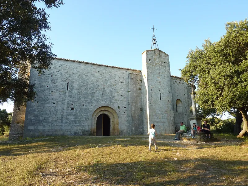
Saint-Sylvestre Church of Montcalmès
No reviews yet
Have you flown here? Share your experience with other pilots.
+ Write the first reviewHistory
11e siècle Eglise romane mentionnée dans le cartulaire de l'abbaye d'Aniane dès les premières années du 12e siècle. La nef était couverte par une charpente apparente, formée de deux pannes et d'une faitière portées par des arcs-doubleaux avec chevrons espacés. Le petit campanile roman a disparu. A l'intérieur, contre le mur ouest de la nef, cinq rangs de gradins s'étagent, et deux au nord. L'abside conserve un reste de décoration peinte géométrique.
Map and restricted areas
Open in the main mapRestricted zones
| Zone | Category | Limits | Conditions |
|---|---|---|---|
| Zrt Victor | ZRT | From the ground up to about 2,000 m above sea level | SUP AIP 219/26 · Du mardi 20 octobre au jeudi 22 octobre 2026 |
| Tarn Est | Zone réglementée | 244 m above ground level → 1341 m above sea level | Vols interdits sauf lorsque the official document of the zone l'autorise explicitement ou avec l'accord du gestionnaire de la zone lorsqu'il est désigné par the official document of the zone |
| Istres | Zone réglementée | 1529 m above sea level → 6259 m above sea level | Vols interdits sauf lorsque the official document of the zone l'autorise explicitement ou avec l'accord du gestionnaire de la zone lorsqu'il est désigné par the official document of the zone |
| Istres | Zone réglementée | 5491 m above sea level → 30766 m above sea level | Vols interdits sauf lorsque the official document of the zone l'autorise explicitement ou avec l'accord du gestionnaire de la zone lorsqu'il est désigné par the official document of the zone |
| Istres | Zone réglementée | 5491 m above sea level → 30766 m above sea level | Vols interdits sauf lorsque the official document of the zone l'autorise explicitement ou avec l'accord du gestionnaire de la zone lorsqu'il est désigné par the official document of the zone |
| Istres | Zone réglementée | 5491 m above sea level → 30766 m above sea level | Vols interdits sauf lorsque the official document of the zone l'autorise explicitement ou avec l'accord du gestionnaire de la zone lorsqu'il est désigné par the official document of the zone |
| Istres | Zone réglementée | 5491 m above sea level → 30766 m above sea level | Vols interdits sauf lorsque the official document of the zone l'autorise explicitement ou avec l'accord du gestionnaire de la zone lorsqu'il est désigné par the official document of the zone |
Nearby aerodromes
Open aerodromes within 25 km of the spot, heliports included, with their distance and direction from the spot. Near an aerodrome, drone flying is prohibited or height-limited: check the UAS zones map.
| Aerodrome | Type | Distance | Elevation |
|---|---|---|---|
| Aérodrome de Saint-Martin-de-Londres | Aerodrome | 18 km NE | 182 m |
| Montpellier Chr Heliport | Heliport | 23 km SE | 46 m |
Aviation weather (METAR and TAF)
LFMT – Montpellier-Méditerranée Airport VFR
METAR
METAR LFMT 171330Z AUTO 22006KT 170V260 9999 BKN100/// OVC130/// ///TCU 15/13 Q1003 TEMPO
- Wind
- 220°, 11 km/h
- Visibility
- 10 km or more
- Clouds
- Broken (5-7/8) at 10,000 ft (3050 m) ; Overcast (8/8) at 13,000 ft (3960 m)
- Temperature
- 15 °C, dew point 13 °C
- QNH
- 1003 hPa
- Flight category
- VFR: ceiling > 3,000 ft and visibility > 5 mi
TAF
TAF LFMT 170800Z 1709/1809 01008KT 9999 BKN016 BECMG 1710/1712 CAVOK TEMPO 1712/1718 -SHRA FEW050TCU BECMG 1713/1715 21010KT
| Period (local time) | Change | Wind | Visibility | Weather | Clouds |
|---|---|---|---|---|---|
| 17/11 10:00 → 17/11 11:00 | Initial conditions | 010°, 15 km/h | 10 km or more | Broken (5-7/8) at 1,600 ft (490 m) | |
| 17/11 11:00 → 17/11 14:00 | Becoming | 010°, 15 km/h | 10 km or more | No significant weather | No significant cloud |
| 17/11 13:00 → 17/11 19:00 | Temporarily | Showers of rain light | Few (1-2/8) at 5,000 ft (1520 m) (towering cumulus) | ||
| 17/11 14:00 → 18/11 10:00 | Becoming | 210°, 19 km/h | 10 km or more | No significant weather | No significant cloud |
Weather and Kp index
| Day | Weather | Temp. min. / max. | Wind | Rain | Max Kp |
|---|---|---|---|---|---|
| Tue 17 Nov | Cloudy | 12° / 16° | 21 km/h W | 1.7 mm | 5 |
| Wed 18 Nov | Fair | 11° / 17° | 27 km/h W | – | 5 |
| Thu 19 Nov | Fair | 11° / 15° | 35 km/h W | 4.7 mm | 3 |
| Fri 20 Nov | Fair | 10° / 15° | 25 km/h W | – | 3 |
| Sat 21 Nov | Partly cloudy | 10° / 16° | 7 km/h W | 0.1 mm | – |
| Sun 22 Nov | Fair | 11° / 15° | 23 km/h W | 0.7 mm | – |
| Mon 23 Nov | Partly cloudy | 10° / 15° | 15 km/h W | – | – |
Hour by hour: Tuesday 17 November
| Time | Weather | Temp. | Wind | Rain | Clouds | Kp |
|---|---|---|---|---|---|---|
| 15:00 | Cloudy | 16° | 18 km/h SW | – | 100 % | 4 |
| 16:00 | Light rain | 15° | 14 km/h SW | 0.2 mm | 100 % | 4 |
| 17:00 | Light rain | 14° | 12 km/h SW | 0.1 mm | 95 % | 4 |
| 18:00 | Cloudy | 13° | 10 km/h SW | – | 91 % | 4 |
| 19:00 | Light rain | 13° | 9 km/h SW | 0.2 mm | 98 % | 5 |
| 20:00 | Cloudy | 12° | 10 km/h W | – | 100 % | 5 |
| 21:00 | Rain | 13° | 12 km/h NW | 0.8 mm | 100 % | 5 |
| 22:00 | Light rain | 13° | 15 km/h NW | 0.4 mm | 100 % | 5 |
Hour by hour: Wednesday 18 November
| Time | Weather | Temp. | Wind | Rain | Clouds | Kp |
|---|---|---|---|---|---|---|
| 06:00 | Cloudy | 12° | 19 km/h SW | – | 96 % | 4 |
| 07:00 | Partly cloudy | 13° | 20 km/h SW | – | 58 % | 4 |
| 08:00 | Cloudy | 13° | 20 km/h SW | – | 88 % | 4 |
| 09:00 | Partly cloudy | 14° | 22 km/h SW | – | 69 % | 4 |
| 10:00 | Cloudy | 15° | 24 km/h W | – | 88 % | 4 |
| 11:00 | Partly cloudy | 16° | 27 km/h W | – | 84 % | 4 |
| 12:00 | Partly cloudy | 16° | 26 km/h W | – | 77 % | 4 |
| 13:00 | Fair | 16° | 24 km/h W | – | 24 % | 3 |
| 14:00 | Fair | 17° | 24 km/h W | – | 23 % | 3 |
| 15:00 | Clear sky | 17° | 22 km/h W | – | 4 % | 3 |
| 16:00 | Fair | 17° | 19 km/h W | – | 13 % | 3 |
| 17:00 | Fair | 15° | 14 km/h W | – | 38 % | 3 |
| 18:00 | Partly cloudy | 13° | 12 km/h W | – | 78 % | 3 |
| 19:00 | Partly cloudy | 12° | 10 km/h W | – | 80 % | 2 |
| 20:00 | Partly cloudy | 11° | 8 km/h W | – | 62 % | 2 |
| 21:00 | Partly cloudy | 11° | 8 km/h SW | – | 83 % | 2 |
| 22:00 | Partly cloudy | 12° | 5 km/h W | – | 98 % | 2 |
Sunrise and sunset
| Day | Dawn | Sunrise | Golden hour | Sunset | Dusk | Day length |
|---|---|---|---|---|---|---|
| Tue 17 Nov | 07:11 | 07:42 | 07:42–08:26 · 16:35–17:19 | 17:19 | 17:50 | 9 h 36 |
| Wed 18 Nov | 07:13 | 07:44 | 07:44–08:28 · 16:34–17:18 | 17:18 | 17:49 | 9 h 34 |
| Thu 19 Nov | 07:14 | 07:45 | 07:45–08:29 · 16:33–17:17 | 17:17 | 17:48 | 9 h 32 |
| Fri 20 Nov | 07:15 | 07:46 | 07:46–08:30 · 16:32–17:16 | 17:16 | 17:48 | 9 h 30 |
| Sat 21 Nov | 07:16 | 07:47 | 07:47–08:32 · 16:31–17:15 | 17:15 | 17:47 | 9 h 28 |
| Sun 22 Nov | 07:17 | 07:49 | 07:49–08:33 · 16:30–17:15 | 17:15 | 17:46 | 9 h 26 |
| Mon 23 Nov | 07:18 | 07:50 | 07:50–08:35 · 16:29–17:14 | 17:14 | 17:46 | 9 h 24 |



Reviews (0)
Log in to review this spot. Log in · Create a free account
No reviews yet. Share yours!