

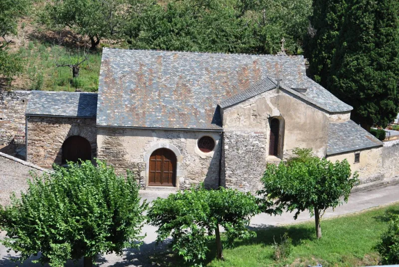
Saint-Jean Chapel
No reviews yet
Have you flown here? Share your experience with other pilots.
+ Write the first reviewHistory
17e siècle Vers la fin du 8e siècle s'est fondé à Citou un monastère de Saint-Jean, berceau de la future abbaye de Caunes. Il ne reste aucune trace de ce monastère primitif. L'église Saint-Jean, construite deux ou trois siècles plus tard, peut en rappeler l'emplacement. Elle fut constituée en paroisse en 1236. Le collateur était l'abbé de Caunes. Vers le milieu du 19e siècle, le conseil de fabrique demanda le transfert de la paroisse dans une nouvelle église, à construire au coeur du village, sous le prétexte que la chapelle champêtre était fréquemment inondée par les crues de l'Argent-Double. Ce transfert eut lieu en 1854 mais les habitants des hameaux demandant que le service soit conservé dans l'ancienne église, d'importantes réparations furent réalisées en 1891 pour exhausser le sol de la nef et les autels, et creuser cent mètres d'aqueduc souterrain pour assécher rapidement le sous-sol après les crues. La partie ancienne de l'église (12e siècle environ) doit comprendre l'abside, les murs de la nef, la chapelle nord et sa voûte en berceau transversal. La réparation de 1659 doit se rapporter à la porte datée et probablement à l'agrandissement, au sud, par une nef formée de deux chapelles. L'apport du 19e siècle se limite au déplacement de la porte, à la construction d'une fausse voûte, d'une sacristie et à l'exhaussement du sol.
Map and restricted areas
Open in the main mapRestricted zones
| Zone | Category | Limits | Conditions |
|---|---|---|---|
| Istres | Zone réglementée | 5491 m above sea level → 30766 m above sea level | Vols interdits sauf lorsque the official document of the zone l'autorise explicitement ou avec l'accord du gestionnaire de la zone lorsqu'il est désigné par the official document of the zone |
Nearby aerodromes
Open aerodromes within 25 km of the spot, heliports included, with their distance and direction from the spot. Near an aerodrome, drone flying is prohibited or height-limited: check the UAS zones map.
No known open aerodrome within 25 km.
Aviation weather (METAR and TAF)
LFMK – Carcassonne Airport VFR
METAR
METAR LFMK 171400Z AUTO VRB03KT 9999 FEW092/// BKN120/// ///TCU 15/14 Q1004 NOSIG
- Wind
- Variable, 6 km/h
- Visibility
- 10 km or more
- Clouds
- Few (1-2/8) at 9,200 ft (2800 m) ; Broken (5-7/8) at 12,000 ft (3660 m)
- Temperature
- 15 °C, dew point 14 °C
- QNH
- 1004 hPa
- Flight category
- VFR: ceiling > 3,000 ft and visibility > 5 mi
TAF
TAF LFMK 170800Z 1709/1809 08008KT 9999 BKN070 TEMPO 1709/1712 -RA SCT004 BKN010 BECMG 1710/1712 VRB03KT TEMPO 1712/1720 SCT025TCU BECMG 1720/1722 CAVOK PROB30 TEMPO 1801/1807 3000 BR BECMG 1806/1808 27010KT 4000 RA BKN020 BKN030
| Period (local time) | Change | Wind | Visibility | Weather | Clouds |
|---|---|---|---|---|---|
| 17/11 10:00 → 17/11 11:00 | Initial conditions | 080°, 15 km/h | 10 km or more | Broken (5-7/8) at 7,000 ft (2130 m) | |
| 17/11 10:00 → 17/11 13:00 | Temporarily | Rain light | Scattered (3-4/8) at 400 ft (120 m) ; Broken (5-7/8) at 1,000 ft (300 m) | ||
| 17/11 11:00 → 17/11 21:00 | Becoming | Variable, 6 km/h | 10 km or more | Broken (5-7/8) at 7,000 ft (2130 m) | |
| 17/11 13:00 → 17/11 21:00 | Temporarily | Scattered (3-4/8) at 2,500 ft (760 m) (towering cumulus) | |||
| 17/11 21:00 → 18/11 07:00 | Becoming | Variable, 6 km/h | 10 km or more | No significant weather | No significant cloud |
| 18/11 02:00 → 18/11 08:00 | Temporarily, probability 30% | 3.0 km | Mist | ||
| 18/11 07:00 → 18/11 10:00 | Becoming | 270°, 19 km/h | 4.0 km | Rain | Broken (5-7/8) at 2,000 ft (610 m) ; Broken (5-7/8) at 3,000 ft (910 m) |
Weather and Kp index
Sunrise and sunset
| Day | Dawn | Sunrise | Golden hour | Sunset | Dusk | Day length |
|---|---|---|---|---|---|---|
| Tue 17 Nov | 07:15 | 07:46 | 07:46–08:29 · 16:40–17:24 | 17:24 | 17:55 | 9 h 38 |
| Wed 18 Nov | 07:16 | 07:47 | 07:47–08:31 · 16:39–17:23 | 17:23 | 17:54 | 9 h 36 |
| Thu 19 Nov | 07:17 | 07:48 | 07:48–08:32 · 16:39–17:22 | 17:22 | 17:53 | 9 h 33 |
| Fri 20 Nov | 07:18 | 07:49 | 07:49–08:33 · 16:38–17:21 | 17:21 | 17:52 | 9 h 31 |
| Sat 21 Nov | 07:20 | 07:51 | 07:51–08:35 · 16:37–17:21 | 17:21 | 17:52 | 9 h 29 |
| Sun 22 Nov | 07:21 | 07:52 | 07:52–08:36 · 16:36–17:20 | 17:20 | 17:51 | 9 h 28 |
| Mon 23 Nov | 07:22 | 07:53 | 07:53–08:37 · 16:35–17:19 | 17:19 | 17:51 | 9 h 26 |
Reviews (0)
Log in to review this spot. Log in · Create a free account
No reviews yet. Share yours!