

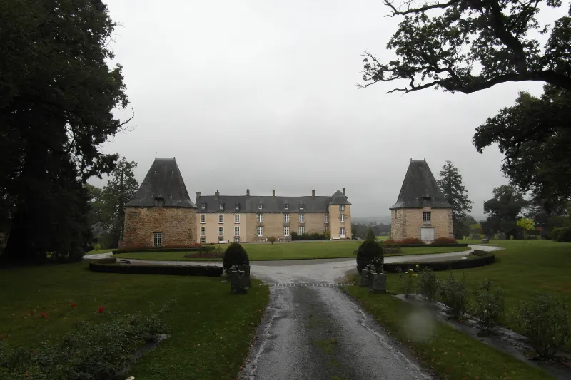
La Robinais Castle
No reviews yet
Have you flown here? Share your experience with other pilots.
+ Write the first reviewHistory
2e moitié 16e siècle ; 2e moitié 17e siècle ; 2e moitié 18e siècle Le château de la Robinais, situé sur une des plus anciennes terres nobles de la commune de Baint-de-Bretagne, se présente de nos jours comme un édifice composite, résultat d'au moins trois campagnes de construction. Du premier manoir construit à l'époque médiévale, rien ne subsiste, excepté peut-être la porte en arc brisé de la cave. La tour d'escalier et les pavillons du logis remontent vraisemblablement à la seconde moitié du 16e siècle. Les deux pavillons situés au sud datent des années 1660, de même peut-être que la façade sud du logis. Toute la moitié occidentale du château est une adjonction de la fin du 18e siècle. De l'important ensemble de bâtiments fermés par une cour qui existaient au 17e siècle ne subsistent aujourd'hui que les pavillons, un peu défigurés, et le colombier transformé en chapelle. L'aspect de l'édifice trahit son histoire compliquée : si la façade sud conserve une harmonie assez classique, malgré la différence de rythme dans les travées perceptible entre la partie occidentale et la partie orientale, le pignon est et une partie de la façade nord conservant le témoignage de l'édifice antérieur. Le château de la Robinais est en définitive remarquable, moins par la qualité de son architecture, sobre et sans grande recherche, que par le témoignage qu'il porte sur l'évolution de cette architecture : il se rattache à la fois à l'architecture manoriale de la seconde moitié du 16e siècle (manoir de la Fresnais, manoir de la Noé en Ercé en Lamée) , et d'autres part aux grandes constructions des 17e et 18e siècles.
Map and restricted areas
Open in the main mapRestricted zones
Nearby aerodromes
Open aerodromes within 25 km of the spot, heliports included, with their distance and direction from the spot. Near an aerodrome, drone flying is prohibited or height-limited: check the UAS zones map.
| Aerodrome | Type | Distance | Elevation |
|---|---|---|---|
| Saint Sulpice des Landes | Aerodrome | 5.6 km S | 93 m |
Aviation weather (METAR and TAF)
LFRN – Rennes-Saint-Jacques Airport MVFR
METAR
METAR LFRN 171330Z AUTO 23022G35KT 9999 OVC028 16/11 Q0991 TEMPO 23025G45KT 1400 TSRAGS BKN008 BKN020CB
- Wind
- 230°, 41 km/h, gusts 65 km/h
- Visibility
- 10 km or more
- Clouds
- Overcast (8/8) at 2,800 ft (850 m)
- Temperature
- 16 °C, dew point 11 °C
- QNH
- 991 hPa
- Flight category
- MVFR: ceiling 1,000–3,000 ft or visibility 3–5 mi
TAF
TAF LFRN 171100Z 1712/1812 23017G30KT 9999 BKN020 TEMPO 1712/1719 23020G35KT 3000 SHRA BKN012 SCT020CB SCT025TCU PROB40 TEMPO 1714/1718 23025G45KT 1400 TSRAGS BKN008 BKN020CB PROB40 TEMPO 1719/1812 3000 SHRA BKN012 BKN020TCU SCT025CB PROB30 TEMPO 1800/1806 1400 TSRA
| Period (local time) | Change | Wind | Visibility | Weather | Clouds |
|---|---|---|---|---|---|
| 17/11 13:00 → 18/11 13:00 | Initial conditions | 230°, 31 km/h, gusts 56 km/h | 10 km or more | Broken (5-7/8) at 2,000 ft (610 m) | |
| 17/11 13:00 → 17/11 20:00 | Temporarily | 230°, 37 km/h, gusts 65 km/h | 3.0 km | Showers of rain | Broken (5-7/8) at 1,200 ft (370 m) ; Scattered (3-4/8) at 2,000 ft (610 m) (cumulonimbus) ; Scattered (3-4/8) at 2,500 ft (760 m) (towering cumulus) |
| 17/11 15:00 → 17/11 19:00 | Temporarily, probability 40% | 230°, 46 km/h, gusts 83 km/h | 1.4 km | Thunderstorm rain ; thunderstorm small hail | Broken (5-7/8) at 800 ft (240 m) ; Broken (5-7/8) at 2,000 ft (610 m) (cumulonimbus) |
| 17/11 20:00 → 18/11 13:00 | Temporarily, probability 40% | 3.0 km | Showers of rain | Broken (5-7/8) at 1,200 ft (370 m) ; Broken (5-7/8) at 2,000 ft (610 m) (towering cumulus) ; Scattered (3-4/8) at 2,500 ft (760 m) (cumulonimbus) | |
| 18/11 01:00 → 18/11 07:00 | Temporarily, probability 30% | 1.4 km | Thunderstorm rain |
Weather and Kp index
| Day | Weather | Temp. min. / max. | Wind | Rain | Max Kp |
|---|---|---|---|---|---|
| Tue 17 Nov | Light rain | 11° / 15° | 38 km/h SW | 2.6 mm | 5 |
| Wed 18 Nov | Clear sky | 11° / 14° | 31 km/h SW | 11 mm | 5 |
| Thu 19 Nov | Cloudy | 9° / 13° | 31 km/h SW | 0.3 mm | 3 |
| Fri 20 Nov | Partly cloudy | 10° / 13° | 26 km/h W | 0.4 mm | 3 |
| Sat 21 Nov | Partly cloudy | 7° / 12° | 20 km/h SE | 1.4 mm | – |
| Sun 22 Nov | Rain | 10° / 12° | 27 km/h SW | 16 mm | – |
| Mon 23 Nov | Showers | 6° / 13° | 16 km/h W | 0.8 mm | – |
Hour by hour: Tuesday 17 November
| Time | Weather | Temp. | Wind | Rain | Clouds | Kp |
|---|---|---|---|---|---|---|
| 15:00 | Light rain | 15° | 38 km/h SW | 0.2 mm | 100 % | 4 |
| 16:00 | Heavy rain | 14° | 36 km/h SW | 1.2 mm | 100 % | 4 |
| 17:00 | Heavy rain | 12° | 32 km/h SW | 1.1 mm | 94 % | 4 |
| 18:00 | Light rain | 12° | 34 km/h SW | 0.1 mm | 100 % | 4 |
| 19:00 | Partly cloudy | 13° | 33 km/h W | – | 73 % | 5 |
| 20:00 | Fair | 12° | 27 km/h W | – | 16 % | 5 |
| 21:00 | Fair | 11° | 24 km/h W | – | 14 % | 5 |
| 22:00 | Clear sky | 12° | 23 km/h SW | – | 12 % | 5 |
Hour by hour: Wednesday 18 November
| Time | Weather | Temp. | Wind | Rain | Clouds | Kp |
|---|---|---|---|---|---|---|
| 06:00 | Partly cloudy | 11° | 24 km/h SW | – | 54 % | 4 |
| 07:00 | Partly cloudy | 11° | 25 km/h SW | – | 62 % | 4 |
| 08:00 | Partly cloudy | 11° | 24 km/h SW | – | 68 % | 4 |
| 09:00 | Partly cloudy | 11° | 25 km/h SW | – | 43 % | 4 |
| 10:00 | Showers | 12° | 25 km/h SW | 0.1 mm | 40 % | 4 |
| 11:00 | Showers | 13° | 28 km/h SW | 0.2 mm | 54 % | 4 |
| 12:00 | Fair | 13° | 27 km/h SW | – | 36 % | 4 |
| 13:00 | Clear sky | 14° | 28 km/h SW | – | 9 % | 3 |
| 14:00 | Showers | 14° | 29 km/h SW | 0.1 mm | 19 % | 3 |
| 15:00 | Fair | 14° | 27 km/h SW | – | 30 % | 3 |
| 16:00 | Cloudy | 14° | 26 km/h SW | – | 98 % | 3 |
| 17:00 | Rain | 13° | 22 km/h SW | 0.8 mm | 100 % | 3 |
| 18:00 | Heavy rain | 12° | 25 km/h SW | 1.2 mm | 100 % | 3 |
| 19:00 | Heavy rain | 11° | 25 km/h S | 4.3 mm | 100 % | 2 |
| 20:00 | Heavy rain | 11° | 27 km/h S | 1.2 mm | 100 % | 2 |
| 21:00 | Light rain | 12° | 31 km/h SW | 0.3 mm | 100 % | 2 |
| 22:00 | Rain | 12° | 29 km/h SW | 0.7 mm | 98 % | 2 |
Sunrise and sunset
| Day | Dawn | Sunrise | Golden hour | Sunset | Dusk | Day length |
|---|---|---|---|---|---|---|
| Tue 17 Nov | 07:42 | 08:15 | 08:15–09:04 · 16:39–17:28 | 17:28 | 18:01 | 9 h 12 |
| Wed 18 Nov | 07:43 | 08:17 | 08:17–09:06 · 16:38–17:27 | 17:27 | 18:00 | 9 h 09 |
| Thu 19 Nov | 07:44 | 08:18 | 08:18–09:07 · 16:37–17:25 | 17:25 | 18:00 | 9 h 07 |
| Fri 20 Nov | 07:46 | 08:20 | 08:20–09:09 · 16:35–17:25 | 17:25 | 17:59 | 9 h 04 |
| Sat 21 Nov | 07:47 | 08:21 | 08:21–09:11 · 16:34–17:24 | 17:24 | 17:58 | 9 h 02 |
| Sun 22 Nov | 07:48 | 08:23 | 08:23–09:12 · 16:33–17:23 | 17:23 | 17:57 | 9 h 00 |
| Mon 23 Nov | 07:50 | 08:24 | 08:24–09:14 · 16:32–17:22 | 17:22 | 17:56 | 8 h 57 |
Reviews (0)
Log in to review this spot. Log in · Create a free account
No reviews yet. Share yours!