

Boschet Castle
No reviews yet
Have you flown here? Share your experience with other pilots.
+ Write the first reviewHistory
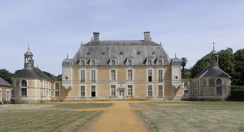
2e moitié 17e siècle ; 18e siècle Le château du Boschet a été édifié entre 1660 à 1680 pour Pierre de Lescouët, premier chambellan du duc d'Orléans, en remplacement de l'ancien manoir. Il est composé d'un grand corps de logis rectangulaire, de plan double en profondeur, comportant un rez-de-chaussée et un étage avec toiture à la Mansart et quatre pavillons d'angle montés sur trompe. Du côté ouest, le château est bordé de deux bâtiments moins élevés construits en retour d'équerre, l'un servant de chapelle, l'autre d'archives. A l'intérieur du château se trouve un magnifique escalier monumental à balustres de pierre blanche. Une seconde campagne de travaux, entre 1720 et 1740, voit la réfection complète de l'intérieur du logis, complété par deux ailes indépendantes en retour d'équerre, à l'ouest, se terminant en corps arrondis, comprenant l'une la chapelle, l'autre un espace de service. Au cours des années 1740-1750 a été créé un jardin ordonnancé intégrant orangerie et communs. Les communs sont formés de trois ailes disposées en U ; ils témoignent d'un souci d'architecture et d'intégration à l'environnement avec les hautes arcades en plein-cintre qui intègrent les fenêtres ; la charpente en bois est d'origine. L'ensemble n'a subi que très peu de modifications au 19e siècle.
Map and restricted areas
Open in the main mapRestricted zones
Nearby aerodromes
Open aerodromes within 25 km of the spot, heliports included, with their distance and direction from the spot. Near an aerodrome, drone flying is prohibited or height-limited: check the UAS zones map.
| Aerodrome | Type | Distance | Elevation |
|---|---|---|---|
| Saint Sulpice des Landes | Aerodrome | 16 km SE | 93 m |
| Rennes-Saint-Jacques Airport | Airport | 17 km N | 38 m |
| Pont Chaillou Heliport | Heliport | 24 km N | 45 m |
Aviation weather (METAR and TAF)
LFRN – Rennes-Saint-Jacques Airport MVFR
METAR
METAR LFRN 171400Z AUTO 23020G32KT 190V260 9999 BKN029 OVC034 16/11 Q0990 TEMPO 23025G45KT 1400 TSRAGS BKN008 BKN020CB
- Wind
- 230°, 37 km/h, gusts 59 km/h
- Visibility
- 10 km or more
- Clouds
- Broken (5-7/8) at 2,900 ft (880 m) ; Overcast (8/8) at 3,400 ft (1040 m)
- Temperature
- 16 °C, dew point 11 °C
- QNH
- 990 hPa
- Flight category
- MVFR: ceiling 1,000–3,000 ft or visibility 3–5 mi
TAF
TAF LFRN 171100Z 1712/1812 23017G30KT 9999 BKN020 TEMPO 1712/1719 23020G35KT 3000 SHRA BKN012 SCT020CB SCT025TCU PROB40 TEMPO 1714/1718 23025G45KT 1400 TSRAGS BKN008 BKN020CB PROB40 TEMPO 1719/1812 3000 SHRA BKN012 BKN020TCU SCT025CB PROB30 TEMPO 1800/1806 1400 TSRA
| Period (local time) | Change | Wind | Visibility | Weather | Clouds |
|---|---|---|---|---|---|
| 17/11 13:00 → 18/11 13:00 | Initial conditions | 230°, 31 km/h, gusts 56 km/h | 10 km or more | Broken (5-7/8) at 2,000 ft (610 m) | |
| 17/11 13:00 → 17/11 20:00 | Temporarily | 230°, 37 km/h, gusts 65 km/h | 3.0 km | Showers of rain | Broken (5-7/8) at 1,200 ft (370 m) ; Scattered (3-4/8) at 2,000 ft (610 m) (cumulonimbus) ; Scattered (3-4/8) at 2,500 ft (760 m) (towering cumulus) |
| 17/11 15:00 → 17/11 19:00 | Temporarily, probability 40% | 230°, 46 km/h, gusts 83 km/h | 1.4 km | Thunderstorm rain ; thunderstorm small hail | Broken (5-7/8) at 800 ft (240 m) ; Broken (5-7/8) at 2,000 ft (610 m) (cumulonimbus) |
| 17/11 20:00 → 18/11 13:00 | Temporarily, probability 40% | 3.0 km | Showers of rain | Broken (5-7/8) at 1,200 ft (370 m) ; Broken (5-7/8) at 2,000 ft (610 m) (towering cumulus) ; Scattered (3-4/8) at 2,500 ft (760 m) (cumulonimbus) | |
| 18/11 01:00 → 18/11 07:00 | Temporarily, probability 30% | 1.4 km | Thunderstorm rain |
Weather and Kp index
Sunrise and sunset
| Day | Dawn | Sunrise | Golden hour | Sunset | Dusk | Day length |
|---|---|---|---|---|---|---|
| Tue 17 Nov | 07:42 | 08:16 | 08:16–09:05 · 16:39–17:28 | 17:28 | 18:02 | 9 h 11 |
| Wed 18 Nov | 07:44 | 08:18 | 08:18–09:06 · 16:38–17:27 | 17:27 | 18:01 | 9 h 09 |
| Thu 19 Nov | 07:45 | 08:19 | 08:19–09:08 · 16:37–17:26 | 17:26 | 18:00 | 9 h 06 |
| Fri 20 Nov | 07:46 | 08:20 | 08:20–09:10 · 16:36–17:25 | 17:25 | 17:59 | 9 h 04 |
| Sat 21 Nov | 07:48 | 08:22 | 08:22–09:11 · 16:34–17:24 | 17:24 | 17:58 | 9 h 01 |
| Sun 22 Nov | 07:49 | 08:23 | 08:23–09:13 · 16:33–17:23 | 17:23 | 17:57 | 8 h 59 |
| Mon 23 Nov | 07:50 | 08:25 | 08:25–09:15 · 16:32–17:22 | 17:22 | 17:57 | 8 h 57 |

Reviews (0)
Log in to review this spot. Log in · Create a free account
No reviews yet. Share yours!