

Saint-Privat Estate
No reviews yet
Have you flown here? Share your experience with other pilots.
+ Write the first reviewHistory
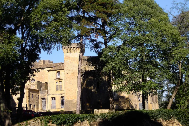
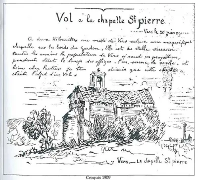
17e siècle ; 18e siècle Château construit sur l'emplacement d'une villa gallo-romaine, avec quelques vestiges d'un fort du 12e siècle, trois tours carrées à bossages et des traces d'importants réaménagements des 15e, 16e, 17e et 18e siècles. Les serres datent d'une reconstitution des jardins au 19e siècle. Le domaine est acquis en 1916 par Jacques Rouché (1862-1957), directeur de l'Opéra de Paris puis de la Réunion des Musées nationaux. Jacques Rouché réaménage les jardins, installant, à la place du potager, un jardin à la française selon les goûts de l'époque (influence d'Achille Duchêne). Il réalise aussi un buffet d'eau à l'imitation de celui de la Mogère à Montpellier. En 1922, Rouché commande à son ami Georges Desvallières (1861-1950), l'un des fondateurs des Ateliers d'Art Sacré, la décoration de la petite chapelle du 18e siècle. Les peintures à l'huile sur toile marouflée traduisent la vision de l'artiste du sacrifice de la guerre de 14-18, qu'il avait vécue dans les tranchées. £
Map and restricted areas
Open in the main mapRestricted zones
| Zone | Category | Limits | Conditions |
|---|---|---|---|
| Rhone | Zone réglementée | 762 m above sea level → 6259 m above sea level | Vols interdits sauf lorsque the official document of the zone l'autorise explicitement ou avec l'accord du gestionnaire de la zone lorsqu'il est désigné par the official document of the zone |
| Istres | Zone réglementée | 5491 m above sea level → 30766 m above sea level | Vols interdits sauf lorsque the official document of the zone l'autorise explicitement ou avec l'accord du gestionnaire de la zone lorsqu'il est désigné par the official document of the zone |
| Istres | Zone réglementée | 5491 m above sea level → 30766 m above sea level | Vols interdits sauf lorsque the official document of the zone l'autorise explicitement ou avec l'accord du gestionnaire de la zone lorsqu'il est désigné par the official document of the zone |
Nearby aerodromes
Open aerodromes within 25 km of the spot, heliports included, with their distance and direction from the spot. Near an aerodrome, drone flying is prohibited or height-limited: check the UAS zones map.
| Aerodrome | Type | Distance | Elevation |
|---|---|---|---|
| Nîmes Courbessac Airport | Aerodrome | 13 km SW | 60 m |
| Uzès Airfield | Aerodrome | 18 km NW | 270 m |
| Aérodrome d'Avignon-Pujaut | Aerodrome | 20 km E | 45 m |
| Nîmes-Arles-Camargue Airport | Airport | 23 km S | 94 m |
| Centre Hospitalier Heliport | Heliport | 23 km E | 21 m |
Aviation weather (METAR and TAF)
LFTW – Nîmes-Arles-Camargue Airport VFR
METAR
METAR LFTW 171330Z AUTO 17003KT 130V230 CAVOK 14/12 Q1003 TEMPO 4000 SHRA SCT070TCU
- Wind
- 170°, 6 km/h
- Visibility
- 10 km or more
- Clouds
- –
- Temperature
- 14 °C, dew point 12 °C
- QNH
- 1003 hPa
- Flight category
- VFR: ceiling > 3,000 ft and visibility > 5 mi
TAF
TAF LFTW 170800Z 1709/1809 03005KT 9999 SCT013 PROB40 TEMPO 1709/1719 BKN006 PROB40 TEMPO 1711/1717 4000 SHRA SCT070TCU BECMG 1716/1718 23010KT
| Period (local time) | Change | Wind | Visibility | Weather | Clouds |
|---|---|---|---|---|---|
| 17/11 10:00 → 17/11 17:00 | Initial conditions | 030°, 9 km/h | 10 km or more | Scattered (3-4/8) at 1,300 ft (400 m) | |
| 17/11 10:00 → 17/11 20:00 | Temporarily, probability 40% | Broken (5-7/8) at 600 ft (180 m) | |||
| 17/11 12:00 → 17/11 18:00 | Temporarily, probability 40% | 4.0 km | Showers of rain | Scattered (3-4/8) at 7,000 ft (2130 m) (towering cumulus) | |
| 17/11 17:00 → 18/11 10:00 | Becoming | 230°, 19 km/h | 10 km or more | Scattered (3-4/8) at 1,300 ft (400 m) |
Weather and Kp index
| Day | Weather | Temp. min. / max. | Wind | Rain | Max Kp |
|---|---|---|---|---|---|
| Tue 17 Nov | Heavy rain | 12° / 15° | 13 km/h S | 6.2 mm | 5 |
| Wed 18 Nov | Clear sky | 11° / 18° | 20 km/h SW | – | 5 |
| Thu 19 Nov | Fair | 10° / 16° | 24 km/h W | 5.5 mm | 3 |
| Fri 20 Nov | Fair | 9° / 15° | 15 km/h SW | – | 3 |
| Sat 21 Nov | Cloudy | 8° / 16° | 13 km/h W | 0.1 mm | – |
| Sun 22 Nov | Clear sky | 10° / 17° | 18 km/h W | 2.7 mm | – |
| Mon 23 Nov | Partly cloudy | 8° / 14° | 14 km/h W | – | – |
Hour by hour: Tuesday 17 November
| Time | Weather | Temp. | Wind | Rain | Clouds | Kp |
|---|---|---|---|---|---|---|
| 15:00 | Heavy rain | 15° | 8 km/h SW | 2.1 mm | 99 % | 4 |
| 16:00 | Heavy rain | 14° | 11 km/h S | 1.0 mm | 100 % | 4 |
| 17:00 | Heavy rain | 13° | 12 km/h S | 2.1 mm | 93 % | 4 |
| 18:00 | Cloudy | 12° | 13 km/h S | – | 99 % | 4 |
| 19:00 | Light rain | 12° | 13 km/h S | 0.4 mm | 100 % | 5 |
| 20:00 | Light rain | 13° | 13 km/h S | 0.3 mm | 100 % | 5 |
| 21:00 | Light rain | 12° | 10 km/h S | 0.3 mm | 100 % | 5 |
| 22:00 | Cloudy | 12° | 12 km/h S | – | 100 % | 5 |
Hour by hour: Wednesday 18 November
| Time | Weather | Temp. | Wind | Rain | Clouds | Kp |
|---|---|---|---|---|---|---|
| 06:00 | Partly cloudy | 12° | 17 km/h SW | – | 73 % | 4 |
| 07:00 | Cloudy | 13° | 17 km/h SW | – | 97 % | 4 |
| 08:00 | Partly cloudy | 13° | 17 km/h SW | – | 40 % | 4 |
| 09:00 | Fair | 14° | 20 km/h SW | – | 16 % | 4 |
| 10:00 | Fair | 16° | 20 km/h SW | – | 13 % | 4 |
| 11:00 | Clear sky | 17° | 17 km/h W | – | 11 % | 4 |
| 12:00 | Fair | 18° | 13 km/h W | – | 14 % | 4 |
| 13:00 | Clear sky | 18° | 15 km/h W | – | 4 % | 3 |
| 14:00 | Clear sky | 18° | 15 km/h W | – | 1 % | 3 |
| 15:00 | Clear sky | 18° | 15 km/h W | – | 11 % | 3 |
| 16:00 | Fair | 17° | 12 km/h SW | – | 22 % | 3 |
| 17:00 | Clear sky | 15° | 15 km/h SW | – | 3 % | 3 |
| 18:00 | Partly cloudy | 13° | 14 km/h W | – | 62 % | 3 |
| 19:00 | Partly cloudy | 12° | 10 km/h W | – | 98 % | 2 |
| 20:00 | Partly cloudy | 11° | 10 km/h SW | – | 99 % | 2 |
| 21:00 | Partly cloudy | 11° | 10 km/h SW | – | 92 % | 2 |
| 22:00 | Partly cloudy | 11° | 11 km/h SW | – | 99 % | 2 |
Sunrise and sunset
| Day | Dawn | Sunrise | Golden hour | Sunset | Dusk | Day length |
|---|---|---|---|---|---|---|
| Tue 17 Nov | 07:08 | 07:39 | 07:39–08:23 · 16:30–17:14 | 17:14 | 17:46 | 9 h 35 |
| Wed 18 Nov | 07:09 | 07:41 | 07:41–08:25 · 16:29–17:14 | 17:14 | 17:45 | 9 h 32 |
| Thu 19 Nov | 07:11 | 07:42 | 07:42–08:26 · 16:28–17:13 | 17:13 | 17:44 | 9 h 30 |
| Fri 20 Nov | 07:12 | 07:43 | 07:43–08:28 · 16:27–17:12 | 17:12 | 17:43 | 9 h 28 |
| Sat 21 Nov | 07:13 | 07:44 | 07:44–08:29 · 16:27–17:11 | 17:11 | 17:43 | 9 h 26 |
| Sun 22 Nov | 07:14 | 07:46 | 07:46–08:30 · 16:26–17:10 | 17:10 | 17:42 | 9 h 24 |
| Mon 23 Nov | 07:15 | 07:47 | 07:47–08:32 · 16:25–17:10 | 17:10 | 17:41 | 9 h 22 |

Reviews (0)
Log in to review this spot. Log in · Create a free account
No reviews yet. Share yours!