

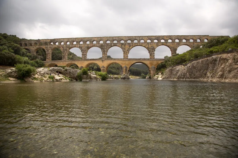
Nîmes Aqueduct
No reviews yet
Have you flown here? Share your experience with other pilots.
+ Write the first reviewHistory
Tronçons de l'aqueduc antique de Nîmes. Vestiges apparents ou enfouis. Pour ce qui est du canal du Pouzin, il semble difficile de séparer les deux tracés ; la question de l'adduction d'eau à Nîmes au 19e siècle n'est pas sans intérêt. Ce deuxième canal double une partie de l'aqueduc : au 19e siècle de multiples projets ont conduit à cet aménagement abandonné ; d'un diamètre supérieur (2, 20 à 3m) , cette conduite reprend le tracé antique jusqu'à lui être parfois superposée et il est alors très difficile de les distinguer l'une de l'autre ; Même si le gabarit plus important impose à certains endroits un rayon de courbure plus grand et donc un écart de 1 à 2m, le tracé récent reste proche et sur la même parcelle que celui de l'époque romaine. Le relief du terrain a varié entre l'antiquité et maintenant, des dépôts d'alluvions modifiant les courbes de niveaux et dissimulant des éperons rocheux responsables d'une légère déviation de l'ouvrage qui les contourne ; ceci à quelques mètres près seulement. C'est pourquoi la protection porte bien sur la totalité des parcelles et non pas sur une simple ligne. Chaque parcelle présente en fait une situation différente. Les vestiges archéologiques dégagés et fouillés sont de deux sortes : 1/ ceux qui présentent uniquement un intérêt scientifique peuvent dans certains cas être réenfouis, une grande partie étant déjà souterraine ; 2/ les parties visibles et notamment les ouvrages d'art comme les ponts peuvent mériter d'être présentés au public et devront être mis à l'abri des dégradations, y compris naturelles .
Map and restricted areas
Open in the main mapRestricted zones
| Zone | Category | Limits | Conditions |
|---|---|---|---|
| Rhone | Zone réglementée | 762 m above sea level → 6259 m above sea level | Vols interdits sauf lorsque the official document of the zone l'autorise explicitement ou avec l'accord du gestionnaire de la zone lorsqu'il est désigné par the official document of the zone |
| Istres | Zone réglementée | 5491 m above sea level → 30766 m above sea level | Vols interdits sauf lorsque the official document of the zone l'autorise explicitement ou avec l'accord du gestionnaire de la zone lorsqu'il est désigné par the official document of the zone |
| Istres | Zone réglementée | 5491 m above sea level → 30766 m above sea level | Vols interdits sauf lorsque the official document of the zone l'autorise explicitement ou avec l'accord du gestionnaire de la zone lorsqu'il est désigné par the official document of the zone |
Nearby aerodromes
Open aerodromes within 25 km of the spot, heliports included, with their distance and direction from the spot. Near an aerodrome, drone flying is prohibited or height-limited: check the UAS zones map.
| Aerodrome | Type | Distance | Elevation |
|---|---|---|---|
| Nîmes Courbessac Airport | Aerodrome | 15 km SW | 60 m |
| Aérodrome d'Avignon-Pujaut | Aerodrome | 18 km E | 45 m |
| Uzès Airfield | Aerodrome | 20 km NW | 270 m |
| Centre Hospitalier Heliport | Heliport | 20 km E | 21 m |
| Nîmes-Arles-Camargue Airport | Airport | 23 km SW | 94 m |
Aviation weather (METAR and TAF)
LFTW – Nîmes-Arles-Camargue Airport VFR
METAR
METAR LFTW 171400Z AUTO 01003KT 340V050 9999 FEW064/// SCT120/// OVC150/// ///TCU 14/12 Q1004 TEMPO 4000 SHRA
- Wind
- 010°, 6 km/h
- Visibility
- 10 km or more
- Clouds
- Few (1-2/8) at 6,400 ft (1950 m) ; Scattered (3-4/8) at 12,000 ft (3660 m) ; Overcast (8/8) at 15,000 ft (4570 m)
- Temperature
- 14 °C, dew point 12 °C
- QNH
- 1004 hPa
- Flight category
- VFR: ceiling > 3,000 ft and visibility > 5 mi
TAF
TAF LFTW 170800Z 1709/1809 03005KT 9999 SCT013 PROB40 TEMPO 1709/1719 BKN006 PROB40 TEMPO 1711/1717 4000 SHRA SCT070TCU BECMG 1716/1718 23010KT
| Period (local time) | Change | Wind | Visibility | Weather | Clouds |
|---|---|---|---|---|---|
| 17/11 10:00 → 17/11 17:00 | Initial conditions | 030°, 9 km/h | 10 km or more | Scattered (3-4/8) at 1,300 ft (400 m) | |
| 17/11 10:00 → 17/11 20:00 | Temporarily, probability 40% | Broken (5-7/8) at 600 ft (180 m) | |||
| 17/11 12:00 → 17/11 18:00 | Temporarily, probability 40% | 4.0 km | Showers of rain | Scattered (3-4/8) at 7,000 ft (2130 m) (towering cumulus) | |
| 17/11 17:00 → 18/11 10:00 | Becoming | 230°, 19 km/h | 10 km or more | Scattered (3-4/8) at 1,300 ft (400 m) |
Weather and Kp index
| Day | Weather | Temp. min. / max. | Wind | Rain | Max Kp |
|---|---|---|---|---|---|
| Tue 17 Nov | Rain | 13° / 16° | 13 km/h S | 4.8 mm | 5 |
| Wed 18 Nov | Clear sky | 11° / 18° | 18 km/h SW | – | 5 |
| Thu 19 Nov | Fair | 10° / 17° | 24 km/h W | 8.1 mm | 3 |
| Fri 20 Nov | Fair | 10° / 15° | 17 km/h W | – | 3 |
| Sat 21 Nov | Cloudy | 8° / 16° | 9 km/h W | 0.2 mm | – |
| Sun 22 Nov | Clear sky | 11° / 18° | 15 km/h W | 3.7 mm | – |
| Mon 23 Nov | Partly cloudy | 8° / 15° | 14 km/h W | – | – |
Hour by hour: Tuesday 17 November
| Time | Weather | Temp. | Wind | Rain | Clouds | Kp |
|---|---|---|---|---|---|---|
| 15:00 | Rain | 16° | 6 km/h SW | 0.7 mm | 99 % | 4 |
| 16:00 | Rain | 15° | 12 km/h S | 0.4 mm | 100 % | 4 |
| 17:00 | Heavy rain | 14° | 13 km/h S | 2.9 mm | 97 % | 4 |
| 18:00 | Light rain | 13° | 13 km/h S | 0.2 mm | 100 % | 4 |
| 19:00 | Cloudy | 13° | 12 km/h S | – | 94 % | 5 |
| 20:00 | Light rain | 13° | 11 km/h S | 0.2 mm | 99 % | 5 |
| 21:00 | Rain | 13° | 10 km/h S | 0.4 mm | 100 % | 5 |
| 22:00 | Cloudy | 13° | 11 km/h S | – | 100 % | 5 |
Hour by hour: Wednesday 18 November
| Time | Weather | Temp. | Wind | Rain | Clouds | Kp |
|---|---|---|---|---|---|---|
| 06:00 | Partly cloudy | 12° | 15 km/h SW | – | 80 % | 4 |
| 07:00 | Cloudy | 12° | 15 km/h SW | – | 100 % | 4 |
| 08:00 | Partly cloudy | 13° | 15 km/h SW | – | 48 % | 4 |
| 09:00 | Partly cloudy | 14° | 18 km/h SW | – | 39 % | 4 |
| 10:00 | Fair | 16° | 18 km/h SW | – | 20 % | 4 |
| 11:00 | Fair | 17° | 16 km/h W | – | 27 % | 4 |
| 12:00 | Partly cloudy | 18° | 13 km/h W | – | 48 % | 4 |
| 13:00 | Clear sky | 18° | 14 km/h SW | – | 2 % | 3 |
| 14:00 | Clear sky | 18° | 14 km/h W | – | 1 % | 3 |
| 15:00 | Clear sky | 18° | 16 km/h SW | – | 6 % | 3 |
| 16:00 | Clear sky | 17° | 13 km/h SW | – | 9 % | 3 |
| 17:00 | Clear sky | 15° | 12 km/h SW | – | 2 % | 3 |
| 18:00 | Fair | 14° | 13 km/h W | – | 33 % | 3 |
| 19:00 | Partly cloudy | 13° | 10 km/h W | – | 92 % | 2 |
| 20:00 | Partly cloudy | 12° | 10 km/h SW | – | 88 % | 2 |
| 21:00 | Partly cloudy | 12° | 8 km/h SW | – | 77 % | 2 |
| 22:00 | Partly cloudy | 11° | 8 km/h S | – | 95 % | 2 |
Sunrise and sunset
| Day | Dawn | Sunrise | Golden hour | Sunset | Dusk | Day length |
|---|---|---|---|---|---|---|
| Tue 17 Nov | 07:08 | 07:39 | 07:39–08:23 · 16:30–17:14 | 17:14 | 17:45 | 9 h 35 |
| Wed 18 Nov | 07:09 | 07:40 | 07:40–08:25 · 16:29–17:13 | 17:13 | 17:45 | 9 h 32 |
| Thu 19 Nov | 07:10 | 07:42 | 07:42–08:26 · 16:28–17:13 | 17:13 | 17:44 | 9 h 30 |
| Fri 20 Nov | 07:12 | 07:43 | 07:43–08:27 · 16:27–17:12 | 17:12 | 17:43 | 9 h 28 |
| Sat 21 Nov | 07:13 | 07:44 | 07:44–08:29 · 16:26–17:11 | 17:11 | 17:43 | 9 h 26 |
| Sun 22 Nov | 07:14 | 07:46 | 07:46–08:30 · 16:26–17:10 | 17:10 | 17:42 | 9 h 24 |
| Mon 23 Nov | 07:15 | 07:47 | 07:47–08:32 · 16:25–17:10 | 17:10 | 17:41 | 9 h 22 |

Reviews (0)
Log in to review this spot. Log in · Create a free account
No reviews yet. Share yours!