

Saint-Géran or Parc Castle
No reviews yet
Have you flown here? Share your experience with other pilots.
+ Write the first reviewHistory
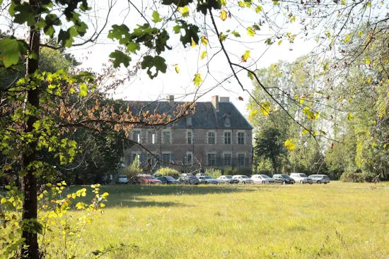
1er quart 17e siècle Château édifié de 1600 à 1610 puis remanié aux 17e et 19e siècles. Composé d'un logis encadré de deux ailes en retour, il présente l'aspect d'une demeure classique, en briques et pierre. A l'intérieur, décor de peintures murales, notamment celle de la chambre de l'enlèvement liée à un épisode de l'histoire du château. Le parc fut sans doute réalisé par l'architecte paysagiste d'Henri IV, Claude Mollet, et représente le premier jardin à la française planté en Bourbonnais. Le parc à l'anglaise fut créé au début du 19e siècle par Claude Vacher. La ferme comprenait des bâtiments répartis autour d'une cour rectangulaire (grand commun nord du début du 17e siècle, communs ouest et logis du 17e siècle, tour pigeonnier circulaire, commun sud en brique contemporain de la construction du château).
Map and restricted areas
Open in the main mapRestricted zones
Nearby aerodromes
Open aerodromes within 25 km of the spot, heliports included, with their distance and direction from the spot. Near an aerodrome, drone flying is prohibited or height-limited: check the UAS zones map.
| Aerodrome | Type | Distance | Elevation |
|---|---|---|---|
| Verneuil en Bourbonnais | Aerodrome | 10 km W | 264 m |
| Aérodrome de Moulins - Montbeugny | Aerodrome | 18 km N | 279 m |
| Lapalisse - Périgny Airfield | Aerodrome | 19 km SE | 317 m |
| Centre Hospitalier Heliport | Heliport | 22 km N | 209 m |
| Vichy-Charmeil Airport | Airport | 23 km S | 249 m |
Aviation weather (METAR and TAF)
LFLV – Vichy-Charmeil Airport VFR
METAR
METAR LFLV 171400Z AUTO 21007KT 140V280 9999 SCT048 SCT056 OVC210 18/10 Q0999
- Wind
- 210°, 13 km/h
- Visibility
- 10 km or more
- Clouds
- Scattered (3-4/8) at 4,800 ft (1460 m) ; Scattered (3-4/8) at 5,600 ft (1710 m) ; Overcast (8/8) at 21,000 ft (6400 m)
- Temperature
- 18 °C, dew point 10 °C
- QNH
- 999 hPa
- Flight category
- VFR: ceiling > 3,000 ft and visibility > 5 mi
TAF
Weather and Kp index
Sunrise and sunset
| Day | Dawn | Sunrise | Golden hour | Sunset | Dusk | Day length |
|---|---|---|---|---|---|---|
| Tue 17 Nov | 07:18 | 07:51 | 07:51–08:37 · 16:25–17:12 | 17:12 | 17:45 | 9 h 21 |
| Wed 18 Nov | 07:19 | 07:52 | 07:52–08:39 · 16:24–17:11 | 17:11 | 17:44 | 9 h 18 |
| Thu 19 Nov | 07:21 | 07:53 | 07:53–08:41 · 16:23–17:10 | 17:10 | 17:43 | 9 h 16 |
| Fri 20 Nov | 07:22 | 07:55 | 07:55–08:42 · 16:22–17:09 | 17:09 | 17:42 | 9 h 14 |
| Sat 21 Nov | 07:23 | 07:56 | 07:56–08:44 · 16:21–17:08 | 17:08 | 17:41 | 9 h 12 |
| Sun 22 Nov | 07:24 | 07:58 | 07:58–08:45 · 16:20–17:07 | 17:07 | 17:41 | 9 h 09 |
| Mon 23 Nov | 07:26 | 07:59 | 07:59–08:47 · 16:19–17:07 | 17:07 | 17:40 | 9 h 07 |
Reviews (0)
Log in to review this spot. Log in · Create a free account
No reviews yet. Share yours!