

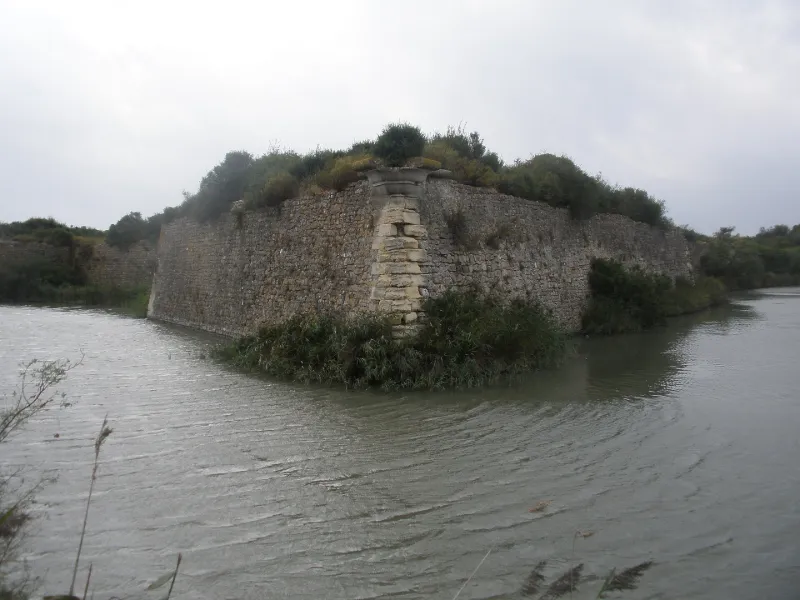
Remains of Peccais Fort
No reviews yet
Have you flown here? Share your experience with other pilots.
+ Write the first reviewHistory
1ère moitié 17e siècle La mission du fort, situé à la rencontre du canal du Bourgidou et de celui de Peccais, était d'assurer un contrôle permanent sur les salines voisines et les canaux servant au transport du sel. La première mention certaine remonte à 1569. A partir de cette date, le fort passe successivement aux mains des Calvinistes et de l'autorité royale jusqu'à la paix d'Alès, signée en 1629. C'est peu après cette date qu'il faut placer la reconstruction du fort de Peccais qui subit peu de transformations au 17e siècle. L'ouvrage est déclassé en 1820. Au cours de la Seconde guerre mondiale, les Allemands y installent des casemates bétonnées. ££Un fossé et un avant-fossé entouraient le fort sur ses quatre fronts (en partie comblé au sud). L'entrée se situait au sud où un pont de bois franchissant le fossé, conduisait au tambour défensif de la porte. Ce dispositif a été augmenté, entre 1716 et 1775, d'un redent et d'une communication crênelée. La porte présentait, au rez-de-chaussée, un encadrement appareillé en harpe et deux pilastres soutenant un fronton à l'étage. Les trois bastions subsistant sont reliés par des courtines conservées sur les fronts nord et est, en partie au sud. Un cul de lampe mouluré, pentagonal, destiné à recevoir une échauguette amovible de bois, garnit la pointe du bastion nord-est. Un cordon de magistrale couronnait le mur taluté des bastions et courtines. Une coursière reliait le sous-sol de la tour sud-ouest aux chambres de tir du bastion nord-ouest. Les bâtiments agrandis et remaniés après 1716, comprenaient les logements du gouverneur, du lieutenant du roi, du major et le casernement. Soit trois corps de bâtiment de deux étages, disposés en U autour d'une cour centrale et dont il ne reste que les vestiges de murs.
Map and restricted areas
Open in the main mapRestricted zones
| Zone | Category | Limits | Conditions |
|---|---|---|---|
| Istres | Zone réglementée | 5491 m above sea level → 30766 m above sea level | Vols interdits sauf lorsque the official document of the zone l'autorise explicitement ou avec l'accord du gestionnaire de la zone lorsqu'il est désigné par the official document of the zone |
| Istres | Zone réglementée | 5491 m above sea level → 30766 m above sea level | Vols interdits sauf lorsque the official document of the zone l'autorise explicitement ou avec l'accord du gestionnaire de la zone lorsqu'il est désigné par the official document of the zone |
| Istres | Zone réglementée | 5491 m above sea level → 30766 m above sea level | Vols interdits sauf lorsque the official document of the zone l'autorise explicitement ou avec l'accord du gestionnaire de la zone lorsqu'il est désigné par the official document of the zone |
| Istres | Zone réglementée | 5491 m above sea level → 30766 m above sea level | Vols interdits sauf lorsque the official document of the zone l'autorise explicitement ou avec l'accord du gestionnaire de la zone lorsqu'il est désigné par the official document of the zone |
| Zrt/zdt Lima 2 | ZRT/ZDT | FL 195 / FL 285 | SUP AIP 219/26 · Du mardi 20 octobre au jeudi 22 octobre 2026 |
Nearby aerodromes
Open aerodromes within 25 km of the spot, heliports included, with their distance and direction from the spot. Near an aerodrome, drone flying is prohibited or height-limited: check the UAS zones map.
| Aerodrome | Type | Distance | Elevation |
|---|---|---|---|
| Aérodrome de Montpellier - Candillargues | Aerodrome | 19 km NW | 2 m |
Aviation weather (METAR and TAF)
LFMT – Montpellier-Méditerranée Airport VFR
METAR
METAR LFMT 171400Z AUTO 25009KT 9999 FEW071/// SCT150/// ///TCU 15/13 Q1004 TEMPO
- Wind
- 250°, 17 km/h
- Visibility
- 10 km or more
- Clouds
- Few (1-2/8) at 7,100 ft (2160 m) ; Scattered (3-4/8) at 15,000 ft (4570 m)
- Temperature
- 15 °C, dew point 13 °C
- QNH
- 1004 hPa
- Flight category
- VFR: ceiling > 3,000 ft and visibility > 5 mi
TAF
TAF LFMT 170800Z 1709/1809 01008KT 9999 BKN016 BECMG 1710/1712 CAVOK TEMPO 1712/1718 -SHRA FEW050TCU BECMG 1713/1715 21010KT
| Period (local time) | Change | Wind | Visibility | Weather | Clouds |
|---|---|---|---|---|---|
| 17/11 10:00 → 17/11 11:00 | Initial conditions | 010°, 15 km/h | 10 km or more | Broken (5-7/8) at 1,600 ft (490 m) | |
| 17/11 11:00 → 17/11 14:00 | Becoming | 010°, 15 km/h | 10 km or more | No significant weather | No significant cloud |
| 17/11 13:00 → 17/11 19:00 | Temporarily | Showers of rain light | Few (1-2/8) at 5,000 ft (1520 m) (towering cumulus) | ||
| 17/11 14:00 → 18/11 10:00 | Becoming | 210°, 19 km/h | 10 km or more | No significant weather | No significant cloud |
Weather and Kp index
| Day | Weather | Temp. min. / max. | Wind | Rain | Max Kp |
|---|---|---|---|---|---|
| Tue 17 Nov | Light rain | 14° / 16° | 28 km/h SW | 1.8 mm | 5 |
| Wed 18 Nov | Fair | 14° / 18° | 35 km/h W | 0.2 mm | 5 |
| Thu 19 Nov | Fair | 13° / 17° | 46 km/h W | 2.7 mm | 3 |
| Fri 20 Nov | Fair | 13° / 16° | 33 km/h W | – | 3 |
| Sat 21 Nov | Partly cloudy | 12° / 16° | 12 km/h W | 0.6 mm | – |
| Sun 22 Nov | Fair | 14° / 17° | 29 km/h NW | 0.2 mm | – |
| Mon 23 Nov | Partly cloudy | 11° / 16° | 22 km/h W | – | – |
Hour by hour: Tuesday 17 November
| Time | Weather | Temp. | Wind | Rain | Clouds | Kp |
|---|---|---|---|---|---|---|
| 15:00 | Light rain | 16° | 26 km/h SW | 0.4 mm | 100 % | 4 |
| 16:00 | Cloudy | 16° | 27 km/h SW | – | 100 % | 4 |
| 17:00 | Cloudy | 16° | 28 km/h SW | – | 98 % | 4 |
| 18:00 | Cloudy | 16° | 26 km/h SW | – | 95 % | 4 |
| 19:00 | Cloudy | 16° | 16 km/h SW | – | 100 % | 5 |
| 20:00 | Cloudy | 16° | 13 km/h W | – | 99 % | 5 |
| 21:00 | Cloudy | 15° | 10 km/h NW | – | 98 % | 5 |
| 22:00 | Heavy rain | 14° | 15 km/h N | 1.1 mm | 100 % | 5 |
Hour by hour: Wednesday 18 November
| Time | Weather | Temp. | Wind | Rain | Clouds | Kp |
|---|---|---|---|---|---|---|
| 06:00 | Cloudy | 16° | 27 km/h W | – | 99 % | 4 |
| 07:00 | Cloudy | 16° | 30 km/h W | – | 93 % | 4 |
| 08:00 | Cloudy | 17° | 31 km/h W | – | 89 % | 4 |
| 09:00 | Cloudy | 18° | 35 km/h W | – | 99 % | 4 |
| 10:00 | Light rain | 17° | 32 km/h W | 0.2 mm | 99 % | 4 |
| 11:00 | Cloudy | 17° | 28 km/h W | – | 98 % | 4 |
| 12:00 | Partly cloudy | 17° | 26 km/h W | – | 38 % | 4 |
| 13:00 | Fair | 18° | 25 km/h W | – | 29 % | 3 |
| 14:00 | Fair | 18° | 25 km/h W | – | 13 % | 3 |
| 15:00 | Fair | 18° | 23 km/h W | – | 26 % | 3 |
| 16:00 | Fair | 18° | 21 km/h W | – | 18 % | 3 |
| 17:00 | Partly cloudy | 16° | 20 km/h W | – | 50 % | 3 |
| 18:00 | Partly cloudy | 15° | 18 km/h SW | – | 88 % | 3 |
| 19:00 | Partly cloudy | 16° | 19 km/h SW | – | 71 % | 2 |
| 20:00 | Partly cloudy | 15° | 19 km/h SW | – | 98 % | 2 |
| 21:00 | Partly cloudy | 15° | 14 km/h SW | – | 66 % | 2 |
| 22:00 | Partly cloudy | 15° | 13 km/h S | – | 97 % | 2 |
Sunrise and sunset
| Day | Dawn | Sunrise | Golden hour | Sunset | Dusk | Day length |
|---|---|---|---|---|---|---|
| Tue 17 Nov | 07:08 | 07:39 | 07:39–08:23 · 16:33–17:17 | 17:17 | 17:48 | 9 h 37 |
| Wed 18 Nov | 07:09 | 07:40 | 07:40–08:24 · 16:32–17:16 | 17:16 | 17:47 | 9 h 35 |
| Thu 19 Nov | 07:11 | 07:42 | 07:42–08:26 · 16:31–17:15 | 17:15 | 17:46 | 9 h 33 |
| Fri 20 Nov | 07:12 | 07:43 | 07:43–08:27 · 16:30–17:14 | 17:14 | 17:45 | 9 h 31 |
| Sat 21 Nov | 07:13 | 07:44 | 07:44–08:28 · 16:29–17:13 | 17:13 | 17:45 | 9 h 29 |
| Sun 22 Nov | 07:14 | 07:45 | 07:45–08:30 · 16:28–17:13 | 17:13 | 17:44 | 9 h 27 |
| Mon 23 Nov | 07:15 | 07:47 | 07:47–08:31 · 16:28–17:12 | 17:12 | 17:43 | 9 h 25 |

Reviews (0)
Log in to review this spot. Log in · Create a free account
No reviews yet. Share yours!