

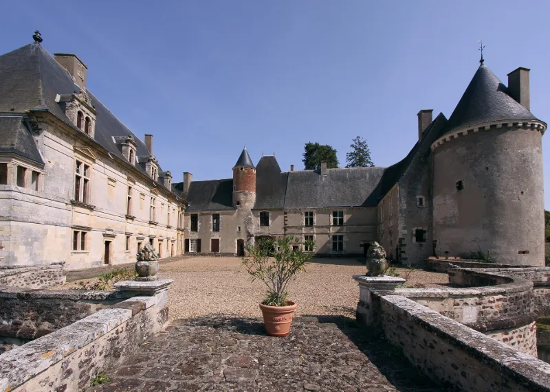
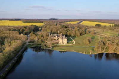
Boucard Castle
No reviews yet
Have you flown here? Share your experience with other pilots.
+ Write the first reviewHistory
4e quart 14e siècle ; 1er quart 16e siècle ; 3e quart 16e siècle ; milieu 18e siècle Faisant suite à une motte féodale élevée de l'autre côté de la Sauldre, le château fut reconstruit sur son site actuel pour les Boucard, famille originaire de Gascogne installée en Berry à la fin du 14e siècle. Du château médiéval subsistent le gros oeuvre du châtelet d'entrée, les murs extérieurs et les tours d'angle du château. Vers 1520, Antoine de Boucard, gentilhomme de la maison de François 1er, combattant des guerres d'Italie, édifia dans le style de la première Renaissance un logis neuf dans l'angle sud de la cour. L'aile nord fut élevée en 1560 pour François de Boucard, écuyer d'Henri II, gouverneur de Verdun, rallié au parti protestant dès le début des guerres de Religion, chef de l'artillerie de Condé. Philibert de Montault de Bénac, maréchal de Navailles, assigné à résidence à Boucard par Louis XIV de 1671 à 1674, fit ouvrir la cour sur la Sauldre et aménager le premier étage de l'aile nord. Au milieu du 18e siècle, le plan des jardins fut donné par Dosmont, élève de l'architecte du roi Jean-Michel Chevotet, pour le fermier général Etienne Perrinet de Jars.
Map and restricted areas
Open in the main mapRestricted zones
Nearby aerodromes
Open aerodromes within 25 km of the spot, heliports included, with their distance and direction from the spot. Near an aerodrome, drone flying is prohibited or height-limited: check the UAS zones map.
| Aerodrome | Type | Distance | Elevation |
|---|---|---|---|
| Base ULM de Sury en Vaux | Aerodrome | 8.4 km NE | 305 m |
| Cosne Sur Loire Airfield | Aerodrome | 18 km E | 177 m |
| Base ULM de Joigny | Aerodrome | 21 km S | 186 m |
Aviation weather (METAR and TAF)
LFOA – Avord (BA 702) Air Base VFR
METAR
METAR LFOA 171400Z AUTO 24023G34KT 9999 SCT035 BKN041 BKN047 17/10 Q0997 TEMPO 4500 SHRA BKN015TCU
- Wind
- 240°, 43 km/h, gusts 63 km/h
- Visibility
- 10 km or more
- Clouds
- Scattered (3-4/8) at 3,500 ft (1070 m) ; Broken (5-7/8) at 4,100 ft (1250 m) ; Broken (5-7/8) at 4,700 ft (1430 m)
- Temperature
- 17 °C, dew point 10 °C
- QNH
- 997 hPa
- Flight category
- VFR: ceiling > 3,000 ft and visibility > 5 mi
TAF
TAF LFOA 170800Z 1709/1809 21020G30KT 9999 BKN020 BKN050 TX17/1714Z TN11/1803Z TEMPO 1709/1711 BKN008 OVC020 PROB40 TEMPO 1711/1716 26025G35KT 4500 SHRA BKN015TCU BECMG 1716/1718 SCT020 TEMPO 1719/1723 25025G40KT 2000 SHRA BKN010 BKN020CB PROB40 TEMPO 1720/1722 26030G50KT TEMPO 1804/1809 27025G40KT 3000 SHRA BKN008 BKN020CB
| Period (local time) | Change | Wind | Visibility | Weather | Clouds |
|---|---|---|---|---|---|
| 17/11 10:00 → 17/11 17:00 | Initial conditions | 210°, 37 km/h, gusts 56 km/h | 10 km or more | Broken (5-7/8) at 2,000 ft (610 m) ; Broken (5-7/8) at 5,000 ft (1520 m) | |
| 17/11 10:00 → 17/11 12:00 | Temporarily | Broken (5-7/8) at 800 ft (240 m) ; Overcast (8/8) at 2,000 ft (610 m) | |||
| 17/11 12:00 → 17/11 17:00 | Temporarily, probability 40% | 260°, 46 km/h, gusts 65 km/h | 4.5 km | Showers of rain | Broken (5-7/8) at 1,500 ft (460 m) (towering cumulus) |
| 17/11 17:00 → 18/11 10:00 | Becoming | 210°, 37 km/h, gusts 56 km/h | 10 km or more | Scattered (3-4/8) at 2,000 ft (610 m) | |
| 17/11 20:00 → 18/11 00:00 | Temporarily | 250°, 46 km/h, gusts 74 km/h | 2.0 km | Showers of rain | Broken (5-7/8) at 1,000 ft (300 m) ; Broken (5-7/8) at 2,000 ft (610 m) (cumulonimbus) |
| 17/11 21:00 → 17/11 23:00 | Temporarily, probability 40% | 260°, 56 km/h, gusts 93 km/h | |||
| 18/11 05:00 → 18/11 10:00 | Temporarily | 270°, 46 km/h, gusts 74 km/h | 3.0 km | Showers of rain | Broken (5-7/8) at 800 ft (240 m) ; Broken (5-7/8) at 2,000 ft (610 m) (cumulonimbus) |
Weather and Kp index
Sunrise and sunset
| Day | Dawn | Sunrise | Golden hour | Sunset | Dusk | Day length |
|---|---|---|---|---|---|---|
| Tue 17 Nov | 07:23 | 07:57 | 07:57–08:44 · 16:24–17:12 | 17:12 | 17:45 | 9 h 15 |
| Wed 18 Nov | 07:24 | 07:58 | 07:58–08:46 · 16:23–17:11 | 17:11 | 17:44 | 9 h 12 |
| Thu 19 Nov | 07:26 | 07:59 | 07:59–08:48 · 16:22–17:10 | 17:10 | 17:44 | 9 h 10 |
| Fri 20 Nov | 07:27 | 08:01 | 08:01–08:49 · 16:20–17:09 | 17:09 | 17:43 | 9 h 08 |
| Sat 21 Nov | 07:28 | 08:02 | 08:02–08:51 · 16:19–17:08 | 17:08 | 17:42 | 9 h 05 |
| Sun 22 Nov | 07:30 | 08:04 | 08:04–08:53 · 16:18–17:07 | 17:07 | 17:41 | 9 h 03 |
| Mon 23 Nov | 07:31 | 08:05 | 08:05–08:54 · 16:17–17:06 | 17:06 | 17:40 | 9 h 01 |
Reviews (0)
Log in to review this spot. Log in · Create a free account
No reviews yet. Share yours!