

Tirepeine Water Mill
No reviews yet
Have you flown here? Share your experience with other pilots.
+ Write the first reviewHistory
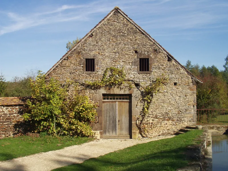
15e siècle ; 18e siècle ; 19e siècle Le moulin de Tirepeine, recensé pour la première fois en 1425, était probablement le plus important de tous ceux implantés sur la Salereine en raison de la longueur de son bief et de la hauteur de la chute ainsi produite. A l'origine placé sous la dépendance de l'abbaye de Saint-Satur, il devient propriété de l'abbaye bénédictine de Saint-Laurent avant de passer, après 1715, aux mains de divers acquéreurs. L'ensemble s'articule alors autour de trois bâtiments: le moulin sur la rivière, le logis et la grange-écurie. Il comprend également deux moulins à blé sous le même toit. Vers 1870, la machinerie actuelle est constituée. Après la seconde guerre mondiale, le moulin stoppe son activité. La roue seule sera alors démontée.£Les bâtiments son typiques de l'architecture traditionnelle de la région. Les fondations ainsi que les murs sont en moellons de grès ferrugineux, enduits au mortier de chaux. Pans de bois hourdés de torchis et toits en tuiles plates complètent cette description. Implanté séparément du logis du meunier, le bâtiment du moulin est une structure simple, composée de trois niveaux: le rez-de-chaussée renferme la machinerie, le premier étage abrite la chambre des meules et le blutoir trouve place au dernier niveau faisant office de grenier. Le système hydraulique est également préservé, à savoir, le bief, la pêcherie, le vivier le déversoir et les vannes.
Map and restricted areas
Open in the main mapRestricted zones
| Zone | Category | Limits | Conditions |
|---|---|---|---|
| Avord | Zone réglementée | 914 m above sea level → 2297 m above sea level | Vols interdits sauf lorsque the official document of the zone l'autorise explicitement ou avec l'accord du gestionnaire de la zone lorsqu'il est désigné par the official document of the zone |
Nearby aerodromes
Open aerodromes within 25 km of the spot, heliports included, with their distance and direction from the spot. Near an aerodrome, drone flying is prohibited or height-limited: check the UAS zones map.
| Aerodrome | Type | Distance | Elevation |
|---|---|---|---|
| Base ULM de Sury en Vaux | Aerodrome | 5.5 km SE | 305 m |
| Cosne Sur Loire Airfield | Aerodrome | 16 km SE | 177 m |
| Base ULM de Beaulieu-sur-Loire | Aerodrome | 18 km NE | 135 m |
| Briare Chatillon Airport | Aerodrome | 23 km N | 164 m |
Aviation weather (METAR and TAF)
LFOA – Avord (BA 702) Air Base VFR
METAR
METAR LFOA 171400Z AUTO 24023G34KT 9999 SCT035 BKN041 BKN047 17/10 Q0997 TEMPO 4500 SHRA BKN015TCU
- Wind
- 240°, 43 km/h, gusts 63 km/h
- Visibility
- 10 km or more
- Clouds
- Scattered (3-4/8) at 3,500 ft (1070 m) ; Broken (5-7/8) at 4,100 ft (1250 m) ; Broken (5-7/8) at 4,700 ft (1430 m)
- Temperature
- 17 °C, dew point 10 °C
- QNH
- 997 hPa
- Flight category
- VFR: ceiling > 3,000 ft and visibility > 5 mi
TAF
TAF LFOA 170800Z 1709/1809 21020G30KT 9999 BKN020 BKN050 TX17/1714Z TN11/1803Z TEMPO 1709/1711 BKN008 OVC020 PROB40 TEMPO 1711/1716 26025G35KT 4500 SHRA BKN015TCU BECMG 1716/1718 SCT020 TEMPO 1719/1723 25025G40KT 2000 SHRA BKN010 BKN020CB PROB40 TEMPO 1720/1722 26030G50KT TEMPO 1804/1809 27025G40KT 3000 SHRA BKN008 BKN020CB
| Period (local time) | Change | Wind | Visibility | Weather | Clouds |
|---|---|---|---|---|---|
| 17/11 10:00 → 17/11 17:00 | Initial conditions | 210°, 37 km/h, gusts 56 km/h | 10 km or more | Broken (5-7/8) at 2,000 ft (610 m) ; Broken (5-7/8) at 5,000 ft (1520 m) | |
| 17/11 10:00 → 17/11 12:00 | Temporarily | Broken (5-7/8) at 800 ft (240 m) ; Overcast (8/8) at 2,000 ft (610 m) | |||
| 17/11 12:00 → 17/11 17:00 | Temporarily, probability 40% | 260°, 46 km/h, gusts 65 km/h | 4.5 km | Showers of rain | Broken (5-7/8) at 1,500 ft (460 m) (towering cumulus) |
| 17/11 17:00 → 18/11 10:00 | Becoming | 210°, 37 km/h, gusts 56 km/h | 10 km or more | Scattered (3-4/8) at 2,000 ft (610 m) | |
| 17/11 20:00 → 18/11 00:00 | Temporarily | 250°, 46 km/h, gusts 74 km/h | 2.0 km | Showers of rain | Broken (5-7/8) at 1,000 ft (300 m) ; Broken (5-7/8) at 2,000 ft (610 m) (cumulonimbus) |
| 17/11 21:00 → 17/11 23:00 | Temporarily, probability 40% | 260°, 56 km/h, gusts 93 km/h | |||
| 18/11 05:00 → 18/11 10:00 | Temporarily | 270°, 46 km/h, gusts 74 km/h | 3.0 km | Showers of rain | Broken (5-7/8) at 800 ft (240 m) ; Broken (5-7/8) at 2,000 ft (610 m) (cumulonimbus) |
Weather and Kp index
Sunrise and sunset
| Day | Dawn | Sunrise | Golden hour | Sunset | Dusk | Day length |
|---|---|---|---|---|---|---|
| Tue 17 Nov | 07:23 | 07:57 | 07:57–08:45 · 16:24–17:12 | 17:12 | 17:45 | 9 h 14 |
| Wed 18 Nov | 07:24 | 07:58 | 07:58–08:46 · 16:22–17:10 | 17:10 | 17:44 | 9 h 12 |
| Thu 19 Nov | 07:26 | 07:59 | 07:59–08:48 · 16:21–17:09 | 17:09 | 17:43 | 9 h 10 |
| Fri 20 Nov | 07:27 | 08:01 | 08:01–08:49 · 16:20–17:09 | 17:09 | 17:42 | 9 h 07 |
| Sat 21 Nov | 07:28 | 08:02 | 08:02–08:51 · 16:19–17:08 | 17:08 | 17:42 | 9 h 05 |
| Sun 22 Nov | 07:30 | 08:04 | 08:04–08:53 · 16:18–17:07 | 17:07 | 17:41 | 9 h 03 |
| Mon 23 Nov | 07:31 | 08:05 | 08:05–08:54 · 16:17–17:06 | 17:06 | 17:40 | 9 h 00 |
Reviews (0)
Log in to review this spot. Log in · Create a free account
No reviews yet. Share yours!