

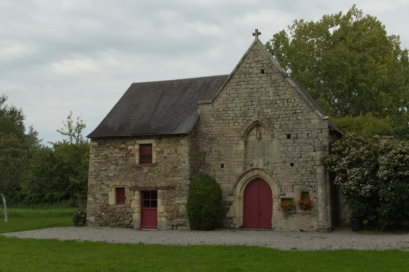
Notre-Dame-de-la-Rivière Chapel, or Chapel of the Marais
No reviews yet
Have you flown here? Share your experience with other pilots.
+ Write the first reviewHistory
15e siècle La paroisse existait dès la fin du 12e siècle. La chapelle est construite au 15e siècle par les seigneurs de Châteaugiron, et se compose d'une simple nef à chevet droit. Le pignon ouest présente, à son angle sud, une colonne demi cylindrique à base et chapiteau moulurés. La porte d'entrée est en arc brisé et ornée d'une archivolte prismatique ainsi que de deux colonnettes à chapiteaux sculptés de feuillages. Elle est surmontée d'une baie en arc brisé remplie par un bas-relief. Le tympan de la baie est rempli par un trilobe et par une niche renfermant une statue de Sainte-Anne posée sur une console à feuillages.
Map and restricted areas
Open in the main mapRestricted zones
| Zone | Category | Limits | Conditions |
|---|---|---|---|
| Tma Rennes |
Région de contrôle terminal | 457 m above sea level → 1067 m above sea level · 762 m above sea level → 3821 m above sea level · 762 m above sea level → 3821 m above sea level · 762 m above sea level → 3821 m above sea level · 1067 m above sea level → 2297 m above sea level · 1529 m above sea level → 3821 m above sea level | Drone flights inside this zone are forbidden without the prior agreement of air traffic control |
Nearby aerodromes
Open aerodromes within 25 km of the spot, heliports included, with their distance and direction from the spot. Near an aerodrome, drone flying is prohibited or height-limited: check the UAS zones map.
| Aerodrome | Type | Distance | Elevation |
|---|---|---|---|
| Pont Chaillou Heliport | Heliport | 15 km NW | 45 m |
| Rennes-Saint-Jacques Airport | Airport | 15 km W | 38 m |
Aviation weather (METAR and TAF)
LFRN – Rennes-Saint-Jacques Airport MVFR
METAR
METAR LFRN 171330Z AUTO 23022G35KT 9999 OVC028 16/11 Q0991 TEMPO 23025G45KT 1400 TSRAGS BKN008 BKN020CB
- Wind
- 230°, 41 km/h, gusts 65 km/h
- Visibility
- 10 km or more
- Clouds
- Overcast (8/8) at 2,800 ft (850 m)
- Temperature
- 16 °C, dew point 11 °C
- QNH
- 991 hPa
- Flight category
- MVFR: ceiling 1,000–3,000 ft or visibility 3–5 mi
TAF
TAF LFRN 171100Z 1712/1812 23017G30KT 9999 BKN020 TEMPO 1712/1719 23020G35KT 3000 SHRA BKN012 SCT020CB SCT025TCU PROB40 TEMPO 1714/1718 23025G45KT 1400 TSRAGS BKN008 BKN020CB PROB40 TEMPO 1719/1812 3000 SHRA BKN012 BKN020TCU SCT025CB PROB30 TEMPO 1800/1806 1400 TSRA
| Period (local time) | Change | Wind | Visibility | Weather | Clouds |
|---|---|---|---|---|---|
| 17/11 13:00 → 18/11 13:00 | Initial conditions | 230°, 31 km/h, gusts 56 km/h | 10 km or more | Broken (5-7/8) at 2,000 ft (610 m) | |
| 17/11 13:00 → 17/11 20:00 | Temporarily | 230°, 37 km/h, gusts 65 km/h | 3.0 km | Showers of rain | Broken (5-7/8) at 1,200 ft (370 m) ; Scattered (3-4/8) at 2,000 ft (610 m) (cumulonimbus) ; Scattered (3-4/8) at 2,500 ft (760 m) (towering cumulus) |
| 17/11 15:00 → 17/11 19:00 | Temporarily, probability 40% | 230°, 46 km/h, gusts 83 km/h | 1.4 km | Thunderstorm rain ; thunderstorm small hail | Broken (5-7/8) at 800 ft (240 m) ; Broken (5-7/8) at 2,000 ft (610 m) (cumulonimbus) |
| 17/11 20:00 → 18/11 13:00 | Temporarily, probability 40% | 3.0 km | Showers of rain | Broken (5-7/8) at 1,200 ft (370 m) ; Broken (5-7/8) at 2,000 ft (610 m) (towering cumulus) ; Scattered (3-4/8) at 2,500 ft (760 m) (cumulonimbus) | |
| 18/11 01:00 → 18/11 07:00 | Temporarily, probability 30% | 1.4 km | Thunderstorm rain |
Weather and Kp index
| Day | Weather | Temp. min. / max. | Wind | Rain | Max Kp |
|---|---|---|---|---|---|
| Tue 17 Nov | Light rain | 11° / 15° | 37 km/h SW | 1.7 mm | 5 |
| Wed 18 Nov | Fair | 10° / 14° | 31 km/h SW | 3.2 mm | 5 |
| Thu 19 Nov | Partly cloudy | 9° / 13° | 31 km/h SW | – | 3 |
| Fri 20 Nov | Showers | 10° / 13° | 24 km/h SW | 0.7 mm | 3 |
| Sat 21 Nov | Cloudy | 6° / 12° | 18 km/h SE | 0.5 mm | – |
| Sun 22 Nov | Light rain | 10° / 12° | 24 km/h SW | 15 mm | – |
| Mon 23 Nov | Clear sky | 6° / 13° | 14 km/h W | 0.3 mm | – |
Hour by hour: Tuesday 17 November
| Time | Weather | Temp. | Wind | Rain | Clouds | Kp |
|---|---|---|---|---|---|---|
| 15:00 | Light rain | 15° | 37 km/h SW | 0.2 mm | 98 % | 4 |
| 16:00 | Rain | 14° | 35 km/h SW | 0.8 mm | 99 % | 4 |
| 17:00 | Rain | 12° | 32 km/h SW | 0.5 mm | 100 % | 4 |
| 18:00 | Light rain | 12° | 32 km/h SW | 0.2 mm | 97 % | 4 |
| 19:00 | Partly cloudy | 12° | 32 km/h SW | – | 64 % | 5 |
| 20:00 | Fair | 12° | 26 km/h W | – | 16 % | 5 |
| 21:00 | Fair | 11° | 24 km/h SW | – | 21 % | 5 |
| 22:00 | Clear sky | 11° | 22 km/h SW | – | 8 % | 5 |
Hour by hour: Wednesday 18 November
| Time | Weather | Temp. | Wind | Rain | Clouds | Kp |
|---|---|---|---|---|---|---|
| 06:00 | Partly cloudy | 11° | 22 km/h SW | – | 50 % | 4 |
| 07:00 | Partly cloudy | 10° | 22 km/h SW | – | 57 % | 4 |
| 08:00 | Partly cloudy | 10° | 23 km/h SW | – | 55 % | 4 |
| 09:00 | Fair | 11° | 24 km/h SW | – | 30 % | 4 |
| 10:00 | Fair | 11° | 24 km/h SW | – | 29 % | 4 |
| 11:00 | Fair | 12° | 22 km/h SW | – | 20 % | 4 |
| 12:00 | Clear sky | 13° | 26 km/h SW | – | 9 % | 4 |
| 13:00 | Fair | 14° | 27 km/h SW | – | 15 % | 3 |
| 14:00 | Fair | 14° | 27 km/h SW | – | 26 % | 3 |
| 15:00 | Fair | 14° | 26 km/h SW | – | 37 % | 3 |
| 16:00 | Cloudy | 14° | 24 km/h SW | – | 99 % | 3 |
| 17:00 | Light rain | 13° | 21 km/h SW | 0.2 mm | 98 % | 3 |
| 18:00 | Rain | 12° | 25 km/h SW | 0.5 mm | 100 % | 3 |
| 19:00 | Heavy rain | 12° | 23 km/h S | 1.4 mm | 98 % | 2 |
| 20:00 | Light rain | 11° | 26 km/h S | 0.4 mm | 95 % | 2 |
| 21:00 | Cloudy | 11° | 31 km/h SW | – | 91 % | 2 |
| 22:00 | Rain | 12° | 30 km/h SW | 0.4 mm | 92 % | 2 |
Sunrise and sunset
| Day | Dawn | Sunrise | Golden hour | Sunset | Dusk | Day length |
|---|---|---|---|---|---|---|
| Tue 17 Nov | 07:42 | 08:16 | 08:16–09:04 · 16:38–17:27 | 17:27 | 18:01 | 9 h 10 |
| Wed 18 Nov | 07:43 | 08:17 | 08:17–09:06 · 16:36–17:25 | 17:25 | 18:00 | 9 h 08 |
| Thu 19 Nov | 07:44 | 08:19 | 08:19–09:08 · 16:35–17:24 | 17:24 | 17:59 | 9 h 05 |
| Fri 20 Nov | 07:46 | 08:20 | 08:20–09:10 · 16:34–17:23 | 17:23 | 17:58 | 9 h 03 |
| Sat 21 Nov | 07:47 | 08:21 | 08:21–09:11 · 16:33–17:22 | 17:22 | 17:57 | 9 h 00 |
| Sun 22 Nov | 07:48 | 08:23 | 08:23–09:13 · 16:32–17:22 | 17:22 | 17:56 | 8 h 58 |
| Mon 23 Nov | 07:50 | 08:24 | 08:24–09:14 · 16:31–17:21 | 17:21 | 17:55 | 8 h 56 |


Reviews (0)
Log in to review this spot. Log in · Create a free account
No reviews yet. Share yours!