

Monbouan Castle
No reviews yet
Have you flown here? Share your experience with other pilots.
+ Write the first reviewHistory
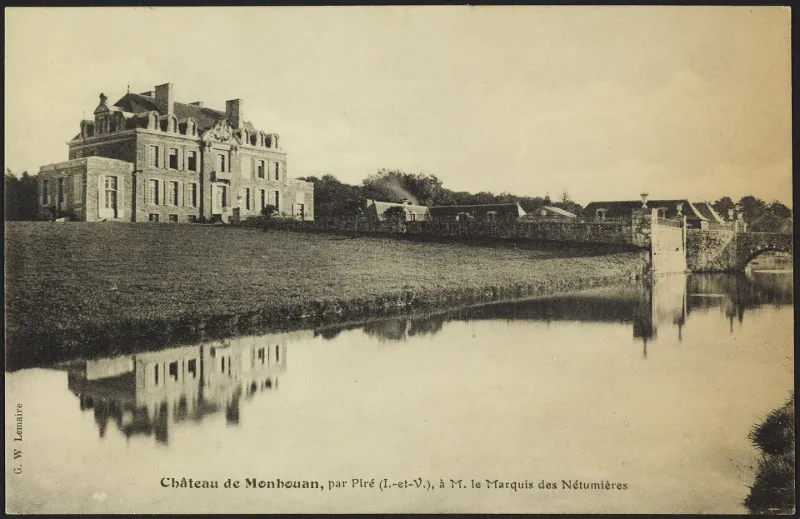
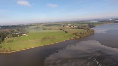
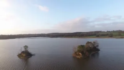
Le château actuel est une construction datant de 1771, oeuvre de l'architecte-ingénieur rennais Besnard. Le corps du logis est un vaste rectangle de sept travées sur deux étages, avec un avant-corps à fronton sculpté. Accolés à chaque extrémité de ce logis principal se trouvent deux petits pavillons : à l'est, la chapelle, et à l'ouest, la bibliothèque. A l'origine, le toit était percé d'oeils-de-boeuf. Au 19e siècle, on les a remplacés par des lucarnes plus monumentales et plus nombreuses, en même temps que d'autres travaux d'aménagement ont été réalisés : installation de deux frontons, doublement en profondeur des pavillons, redistribution des pièces du château faite par l'architecte Martenot, avec notamment la création d'un grand corridor au 1er étage. Dans les années 1970, le père des actuelles propriétaires a fait enlever les lucarnes du 19e siècle à l'occasion de la réfection de la toiture, mais sans remettre les oeils-de-boeuf, faute de moyens, laissant dans l'obscurité l'étage sous combles pourtant aménagé en pièces d'habitation. Autour du château, qui dispose de 200 hectares de terres, on trouve un ensemble de communs, un verger avec la maison du jardinier et un colombier, un lavoir face à un canal, des douves en eau et un étang avec une île.
Map and restricted areas
Open in the main mapRestricted zones
| Zone | Category | Limits | Conditions |
|---|---|---|---|
| Tma Rennes |
Région de contrôle terminal | 457 m above sea level → 1067 m above sea level · 762 m above sea level → 3821 m above sea level · 762 m above sea level → 3821 m above sea level · 762 m above sea level → 3821 m above sea level · 1067 m above sea level → 2297 m above sea level · 1529 m above sea level → 3821 m above sea level | Drone flights inside this zone are forbidden without the prior agreement of air traffic control |
Nearby aerodromes
Open aerodromes within 25 km of the spot, heliports included, with their distance and direction from the spot. Near an aerodrome, drone flying is prohibited or height-limited: check the UAS zones map.
No known open aerodrome within 25 km.
Aviation weather (METAR and TAF)
LFRN – Rennes-Saint-Jacques Airport MVFR
METAR
METAR LFRN 171400Z AUTO 23020G32KT 190V260 9999 BKN029 OVC034 16/11 Q0990 TEMPO 23025G45KT 1400 TSRAGS BKN008 BKN020CB
- Wind
- 230°, 37 km/h, gusts 59 km/h
- Visibility
- 10 km or more
- Clouds
- Broken (5-7/8) at 2,900 ft (880 m) ; Overcast (8/8) at 3,400 ft (1040 m)
- Temperature
- 16 °C, dew point 11 °C
- QNH
- 990 hPa
- Flight category
- MVFR: ceiling 1,000–3,000 ft or visibility 3–5 mi
TAF
TAF LFRN 171100Z 1712/1812 23017G30KT 9999 BKN020 TEMPO 1712/1719 23020G35KT 3000 SHRA BKN012 SCT020CB SCT025TCU PROB40 TEMPO 1714/1718 23025G45KT 1400 TSRAGS BKN008 BKN020CB PROB40 TEMPO 1719/1812 3000 SHRA BKN012 BKN020TCU SCT025CB PROB30 TEMPO 1800/1806 1400 TSRA
| Period (local time) | Change | Wind | Visibility | Weather | Clouds |
|---|---|---|---|---|---|
| 17/11 13:00 → 18/11 13:00 | Initial conditions | 230°, 31 km/h, gusts 56 km/h | 10 km or more | Broken (5-7/8) at 2,000 ft (610 m) | |
| 17/11 13:00 → 17/11 20:00 | Temporarily | 230°, 37 km/h, gusts 65 km/h | 3.0 km | Showers of rain | Broken (5-7/8) at 1,200 ft (370 m) ; Scattered (3-4/8) at 2,000 ft (610 m) (cumulonimbus) ; Scattered (3-4/8) at 2,500 ft (760 m) (towering cumulus) |
| 17/11 15:00 → 17/11 19:00 | Temporarily, probability 40% | 230°, 46 km/h, gusts 83 km/h | 1.4 km | Thunderstorm rain ; thunderstorm small hail | Broken (5-7/8) at 800 ft (240 m) ; Broken (5-7/8) at 2,000 ft (610 m) (cumulonimbus) |
| 17/11 20:00 → 18/11 13:00 | Temporarily, probability 40% | 3.0 km | Showers of rain | Broken (5-7/8) at 1,200 ft (370 m) ; Broken (5-7/8) at 2,000 ft (610 m) (towering cumulus) ; Scattered (3-4/8) at 2,500 ft (760 m) (cumulonimbus) | |
| 18/11 01:00 → 18/11 07:00 | Temporarily, probability 30% | 1.4 km | Thunderstorm rain |
Weather and Kp index
| Day | Weather | Temp. min. / max. | Wind | Rain | Max Kp |
|---|---|---|---|---|---|
| Tue 17 Nov | Light rain | 11° / 15° | 37 km/h SW | 1.7 mm | 5 |
| Wed 18 Nov | Fair | 11° / 14° | 31 km/h SW | 6.6 mm | 5 |
| Thu 19 Nov | Partly cloudy | 9° / 13° | 31 km/h SW | – | 3 |
| Fri 20 Nov | Showers | 10° / 14° | 27 km/h SW | 0.9 mm | 3 |
| Sat 21 Nov | Cloudy | 6° / 12° | 19 km/h SE | 0.5 mm | – |
| Sun 22 Nov | Light rain | 10° / 12° | 27 km/h SW | 14 mm | – |
| Mon 23 Nov | Showers | 6° / 13° | 15 km/h W | 0.6 mm | – |
Hour by hour: Tuesday 17 November
| Time | Weather | Temp. | Wind | Rain | Clouds | Kp |
|---|---|---|---|---|---|---|
| 15:00 | Light rain | 15° | 37 km/h SW | 0.2 mm | 99 % | 4 |
| 16:00 | Rain | 15° | 35 km/h SW | 0.9 mm | 100 % | 4 |
| 17:00 | Rain | 12° | 32 km/h SW | 0.6 mm | 98 % | 4 |
| 18:00 | Cloudy | 12° | 34 km/h SW | – | 98 % | 4 |
| 19:00 | Partly cloudy | 12° | 33 km/h SW | – | 60 % | 5 |
| 20:00 | Fair | 12° | 28 km/h W | – | 22 % | 5 |
| 21:00 | Fair | 11° | 24 km/h W | – | 16 % | 5 |
| 22:00 | Clear sky | 11° | 22 km/h SW | – | 3 % | 5 |
Hour by hour: Wednesday 18 November
| Time | Weather | Temp. | Wind | Rain | Clouds | Kp |
|---|---|---|---|---|---|---|
| 06:00 | Partly cloudy | 11° | 23 km/h SW | – | 50 % | 4 |
| 07:00 | Partly cloudy | 11° | 23 km/h SW | – | 67 % | 4 |
| 08:00 | Partly cloudy | 11° | 24 km/h SW | – | 63 % | 4 |
| 09:00 | Fair | 11° | 25 km/h SW | – | 30 % | 4 |
| 10:00 | Showers | 11° | 24 km/h SW | 0.2 mm | 27 % | 4 |
| 11:00 | Partly cloudy | 12° | 23 km/h SW | – | 45 % | 4 |
| 12:00 | Fair | 13° | 27 km/h SW | – | 27 % | 4 |
| 13:00 | Fair | 14° | 27 km/h SW | – | 14 % | 3 |
| 14:00 | Fair | 14° | 28 km/h SW | – | 24 % | 3 |
| 15:00 | Fair | 14° | 27 km/h SW | – | 29 % | 3 |
| 16:00 | Cloudy | 14° | 26 km/h SW | – | 98 % | 3 |
| 17:00 | Light rain | 13° | 22 km/h SW | 0.3 mm | 99 % | 3 |
| 18:00 | Rain | 12° | 25 km/h SW | 0.7 mm | 100 % | 3 |
| 19:00 | Heavy rain | 12° | 25 km/h S | 2.5 mm | 99 % | 2 |
| 20:00 | Heavy rain | 11° | 26 km/h S | 1.4 mm | 97 % | 2 |
| 21:00 | Light rain | 11° | 31 km/h SW | 0.2 mm | 100 % | 2 |
| 22:00 | Light rain | 12° | 30 km/h SW | 0.3 mm | 97 % | 2 |
Sunrise and sunset
| Day | Dawn | Sunrise | Golden hour | Sunset | Dusk | Day length |
|---|---|---|---|---|---|---|
| Tue 17 Nov | 07:41 | 08:15 | 08:15–09:04 · 16:37–17:26 | 17:26 | 18:00 | 9 h 11 |
| Wed 18 Nov | 07:42 | 08:16 | 08:16–09:05 · 16:36–17:25 | 17:25 | 17:59 | 9 h 08 |
| Thu 19 Nov | 07:44 | 08:18 | 08:18–09:07 · 16:35–17:24 | 17:24 | 17:58 | 9 h 06 |
| Fri 20 Nov | 07:45 | 08:19 | 08:19–09:09 · 16:33–17:23 | 17:23 | 17:57 | 9 h 03 |
| Sat 21 Nov | 07:46 | 08:21 | 08:21–09:10 · 16:32–17:22 | 17:22 | 17:56 | 9 h 01 |
| Sun 22 Nov | 07:48 | 08:22 | 08:22–09:12 · 16:31–17:21 | 17:21 | 17:56 | 8 h 58 |
| Mon 23 Nov | 07:49 | 08:24 | 08:24–09:14 · 16:30–17:20 | 17:20 | 17:55 | 8 h 56 |


Reviews (0)
Log in to review this spot. Log in · Create a free account
No reviews yet. Share yours!