

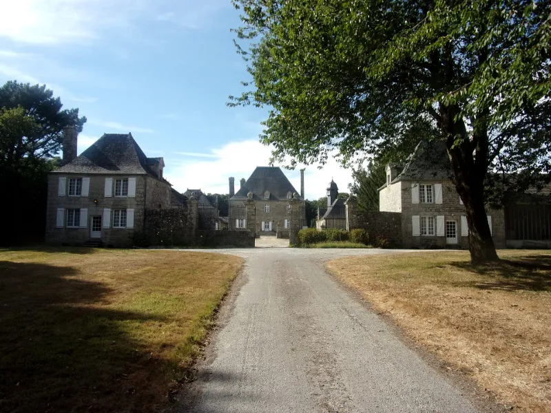
Trégarantec Castle
No reviews yet
Have you flown here? Share your experience with other pilots.
+ Write the first reviewHistory
4e quart 17e siècle ; 18e siècle L'actuel château de Trégarantec date de 1698 et est l'oeuvre de François-René Jégou du Laz, conseiller au Parlement de Bretagne. Il était à l'origine composé de deux ailes disposées en équerre, mais l'aile qui longeait les jardins, peut-être antérieure au corps principal, a été détruite au début du 20e siècle et reconstruite en 1970. Les boiseries des salons qui l'occupaient ont été partiellement remontées dans différentes pièces du logis actuel. Devant le logis se développe la cour d'honneur, divisée en deux parties par un muret. L'entrée est flanquée de chaque côté par deux pavillons contemporains du château. A gauche de la cour se succèdent différents bâtiments, communs, remises et écuries, dont certains sont très remaniés. A droite se trouve la chapelle, construite en 1755 puis transformée en sacristie en 1768. Une balustrade en granit et des piliers marquent l'entrée du jardin auquel on accède par un grand escalier à trois paliers. Le jardin à la française est entièrement clos de murs, et réparti en trois terrasses séparées par des murets. La première a conservé son orangerie, et la deuxième son puits. La ferme a été construite dans les années 1944-1945.
Map and restricted areas
Open in the main mapRestricted zones
| Zone | Category | Limits | Conditions |
|---|---|---|---|
| Argoat | Zone réglementée | 3053 m above sea level → 6259 m above sea level | Vols interdits sauf lorsque the official document of the zone l'autorise explicitement ou avec l'accord du gestionnaire de la zone lorsqu'il est désigné par the official document of the zone |
| Zrt Guerledan | ZRT | From about 3,800 m to about 4,100 m above sea level | SUP AIP 053/26 · Du jeudi 16 avril 2026 au mercredi 12 avril 2028 |
| Zrt Guerledan High | ZRT | From about 6,250 m to about 6,550 m above sea level | SUP AIP 053/26 · Du jeudi 16 avril 2026 au mercredi 12 avril 2028 |
Nearby aerodromes
Open aerodromes within 25 km of the spot, heliports included, with their distance and direction from the spot. Near an aerodrome, drone flying is prohibited or height-limited: check the UAS zones map.
No known open aerodrome within 25 km.
Aviation weather (METAR and TAF)
LFRH – Lorient South Brittany (Bretagne Sud) Airport MVFR
METAR
METAR LFRH 171400Z AUTO 22026KT 9999 FEW020 BKN029 BKN088 15/12 Q0990 TEMPO 25020G40KT 1500 TSRA BKN008 BKN012CB
- Wind
- 220°, 48 km/h
- Visibility
- 10 km or more
- Clouds
- Few (1-2/8) at 2,000 ft (610 m) ; Broken (5-7/8) at 2,900 ft (880 m) ; Broken (5-7/8) at 8,800 ft (2680 m)
- Temperature
- 15 °C, dew point 12 °C
- QNH
- 990 hPa
- Flight category
- MVFR: ceiling 1,000–3,000 ft or visibility 3–5 mi
TAF
TAF LFRH 171100Z 1712/1812 24020G30KT 9999 SCT021 BKN054 PROB40 TEMPO 1712/1713 4000 SHRA SCT020TCU TEMPO 1713/1717 3500 RA BKN014 BKN015CB PROB40 TEMPO 1714/1717 25020G40KT 1500 TSRA BKN008 BKN012CB TEMPO 1717/1812 4000 SHRA SCT025TCU SCT030CB PROB40 TEMPO 1718/1812 BKN014
| Period (local time) | Change | Wind | Visibility | Weather | Clouds |
|---|---|---|---|---|---|
| 17/11 13:00 → 18/11 13:00 | Initial conditions | 240°, 37 km/h, gusts 56 km/h | 10 km or more | Scattered (3-4/8) at 2,100 ft (640 m) ; Broken (5-7/8) at 5,400 ft (1650 m) | |
| 17/11 13:00 → 17/11 14:00 | Temporarily, probability 40% | 4.0 km | Showers of rain | Scattered (3-4/8) at 2,000 ft (610 m) (towering cumulus) | |
| 17/11 14:00 → 17/11 18:00 | Temporarily | 3.5 km | Rain | Broken (5-7/8) at 1,400 ft (430 m) ; Broken (5-7/8) at 1,500 ft (460 m) (cumulonimbus) | |
| 17/11 15:00 → 17/11 18:00 | Temporarily, probability 40% | 250°, 37 km/h, gusts 74 km/h | 1.5 km | Thunderstorm rain | Broken (5-7/8) at 800 ft (240 m) ; Broken (5-7/8) at 1,200 ft (370 m) (cumulonimbus) |
| 17/11 18:00 → 18/11 13:00 | Temporarily | 4.0 km | Showers of rain | Scattered (3-4/8) at 2,500 ft (760 m) (towering cumulus) ; Scattered (3-4/8) at 3,000 ft (910 m) (cumulonimbus) | |
| 17/11 19:00 → 18/11 13:00 | Temporarily, probability 40% | Broken (5-7/8) at 1,400 ft (430 m) |
Weather and Kp index
Sunrise and sunset
| Day | Dawn | Sunrise | Golden hour | Sunset | Dusk | Day length |
|---|---|---|---|---|---|---|
| Tue 17 Nov | 07:49 | 08:23 | 08:23–09:12 · 16:44–17:33 | 17:33 | 18:07 | 9 h 10 |
| Wed 18 Nov | 07:51 | 08:25 | 08:25–09:14 · 16:43–17:32 | 17:32 | 18:06 | 9 h 07 |
| Thu 19 Nov | 07:52 | 08:26 | 08:26–09:16 · 16:42–17:31 | 17:31 | 18:06 | 9 h 04 |
| Fri 20 Nov | 07:53 | 08:28 | 08:28–09:17 · 16:41–17:30 | 17:30 | 18:05 | 9 h 02 |
| Sat 21 Nov | 07:55 | 08:29 | 08:29–09:19 · 16:39–17:29 | 17:29 | 18:04 | 9 h 00 |
| Sun 22 Nov | 07:56 | 08:31 | 08:31–09:21 · 16:38–17:28 | 17:28 | 18:03 | 8 h 57 |
| Mon 23 Nov | 07:57 | 08:32 | 08:32–09:22 · 16:37–17:27 | 17:27 | 18:02 | 8 h 55 |




Reviews (0)
Log in to review this spot. Log in · Create a free account
No reviews yet. Share yours!