

Ty-ar-Boudiged Dolmen
No reviews yet
Have you flown here? Share your experience with other pilots.
+ Write the first reviewHistory
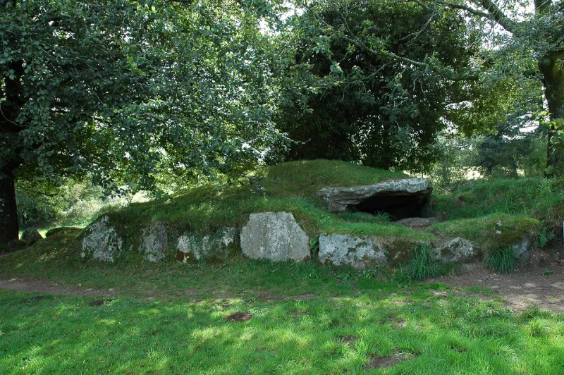
Protohistoire Représentatif des sépultures en V. Le dolmen de Ty-ar-Boudiged est un remarquable exemplaire des sépultures en V, type de transition entre les dolmens à couloir et les allées couvertes. La chambre, longue de plus de 13 m, s'évase régulièrement depuis l'entrée, large de 1, 7 m, jusqu'au fond (3, 1m). De même, la hauteur interne augmente vers le fond où se note un pilier non fonctionnel. La couverture de l'entrée a disparu, mais trois dalles sont encore en place. Le tertre est bien conservé et est délimité de chaque côté par une ligne de dalles dressées qui paraissent dessiner un plan piriforme.
Map and restricted areas
Open in the main mapRestricted zones
| Zone | Category | Limits | Conditions |
|---|---|---|---|
| Venec | Parc et réserve naturelle | 0 m above ground level → 305 m above ground level | Flying over the core of the park is forbidden to drones, unless the manager gives permission |
Nearby aerodromes
Open aerodromes within 25 km of the spot, heliports included, with their distance and direction from the spot. Near an aerodrome, drone flying is prohibited or height-limited: check the UAS zones map.
| Aerodrome | Type | Distance | Elevation |
|---|---|---|---|
| Mairie Heliport | Heliport | 18 km S | 151 m |
Aviation weather (METAR and TAF)
LFRU – Morlaix-Ploujean Airport IFR
METAR
METAR LFRU 171400Z AUTO 24025G39KT 3500 RA BR SCT017/// BKN025/// BKN035/// ///CB 13/11 Q0987
- Wind
- 240°, 46 km/h, gusts 72 km/h
- Visibility
- 3.5 km
- Weather
- Rain ; mist
- Clouds
- Scattered (3-4/8) at 1,700 ft (520 m) ; Broken (5-7/8) at 2,500 ft (760 m) ; Broken (5-7/8) at 3,500 ft (1070 m)
- Temperature
- 13 °C, dew point 11 °C
- QNH
- 987 hPa
- Flight category
- IFR: ceiling 500–1,000 ft or visibility 1–3 mi
TAF
Weather and Kp index
Sunrise and sunset
| Day | Dawn | Sunrise | Golden hour | Sunset | Dusk | Day length |
|---|---|---|---|---|---|---|
| Tue 17 Nov | 07:52 | 08:26 | 08:26–09:15 · 16:46–17:35 | 17:35 | 18:09 | 9 h 08 |
| Wed 18 Nov | 07:53 | 08:27 | 08:27–09:17 · 16:44–17:34 | 17:34 | 18:08 | 9 h 06 |
| Thu 19 Nov | 07:54 | 08:29 | 08:29–09:19 · 16:43–17:33 | 17:33 | 18:07 | 9 h 03 |
| Fri 20 Nov | 07:56 | 08:30 | 08:30–09:20 · 16:42–17:32 | 17:32 | 18:06 | 9 h 01 |
| Sat 21 Nov | 07:57 | 08:32 | 08:32–09:22 · 16:41–17:31 | 17:31 | 18:05 | 8 h 58 |
| Sun 22 Nov | 07:58 | 08:33 | 08:33–09:24 · 16:39–17:30 | 17:30 | 18:05 | 8 h 56 |
| Mon 23 Nov | 08:00 | 08:35 | 08:35–09:25 · 16:38–17:29 | 17:29 | 18:04 | 8 h 54 |


Reviews (0)
Log in to review this spot. Log in · Create a free account
No reviews yet. Share yours!