

Rospellem Motte
No reviews yet
Have you flown here? Share your experience with other pilots.
+ Write the first reviewHistory
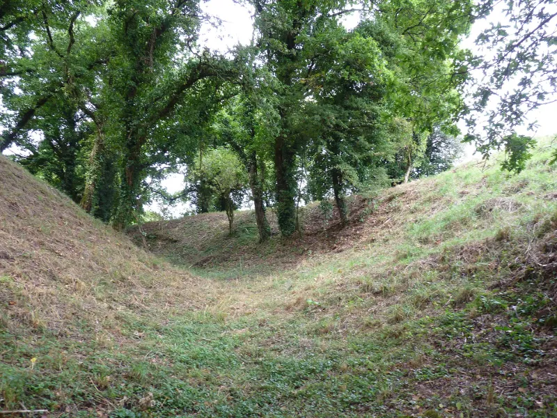
Milieu du Moyen Age L'ensemble fortifié, à vocation militaire et économique, occupe l'extrémité sud d'un éperon dominant la confluence de l'Aulne avec le ruisseau de Landeren. Il est composé de deux parties principales : une motte en position de barrage entourée d'un large fossé sec et une basse-cour située au sud, occupant l'extrémité de l'éperon. De forme tronconique, le tertre est haut d'une quinzaine de mètres. La plate-forme sommitale, partiellement perturbée par des creusements, comporte des vestiges de construction en pierre. La basse-cour est protégée par une importante levée de terre doublée d'un fossé sec. Le site est en très bon état.
Map and restricted areas
Open in the main mapRestricted zones
Nearby aerodromes
Open aerodromes within 25 km of the spot, heliports included, with their distance and direction from the spot. Near an aerodrome, drone flying is prohibited or height-limited: check the UAS zones map.
No known open aerodrome within 25 km.
Aviation weather (METAR and TAF)
LFRU – Morlaix-Ploujean Airport IFR
METAR
METAR LFRU 171400Z AUTO 24025G39KT 3500 RA BR SCT017/// BKN025/// BKN035/// ///CB 13/11 Q0987
- Wind
- 240°, 46 km/h, gusts 72 km/h
- Visibility
- 3.5 km
- Weather
- Rain ; mist
- Clouds
- Scattered (3-4/8) at 1,700 ft (520 m) ; Broken (5-7/8) at 2,500 ft (760 m) ; Broken (5-7/8) at 3,500 ft (1070 m)
- Temperature
- 13 °C, dew point 11 °C
- QNH
- 987 hPa
- Flight category
- IFR: ceiling 500–1,000 ft or visibility 1–3 mi
TAF
Weather and Kp index
Sunrise and sunset
| Day | Dawn | Sunrise | Golden hour | Sunset | Dusk | Day length |
|---|---|---|---|---|---|---|
| Tue 17 Nov | 07:51 | 08:25 | 08:25–09:14 · 16:44–17:34 | 17:34 | 18:08 | 9 h 08 |
| Wed 18 Nov | 07:52 | 08:27 | 08:27–09:16 · 16:43–17:33 | 17:33 | 18:07 | 9 h 06 |
| Thu 19 Nov | 07:54 | 08:28 | 08:28–09:18 · 16:42–17:32 | 17:32 | 18:06 | 9 h 03 |
| Fri 20 Nov | 07:55 | 08:29 | 08:29–09:19 · 16:41–17:31 | 17:31 | 18:05 | 9 h 01 |
| Sat 21 Nov | 07:56 | 08:31 | 08:31–09:21 · 16:39–17:30 | 17:30 | 18:04 | 8 h 58 |
| Sun 22 Nov | 07:58 | 08:32 | 08:32–09:23 · 16:38–17:29 | 17:29 | 18:03 | 8 h 56 |
| Mon 23 Nov | 07:59 | 08:34 | 08:34–09:24 · 16:37–17:28 | 17:28 | 18:03 | 8 h 53 |

Reviews (0)
Log in to review this spot. Log in · Create a free account
No reviews yet. Share yours!