

Saint Gildas Chapel
No reviews yet
Have you flown here? Share your experience with other pilots.
+ Write the first reviewHistory
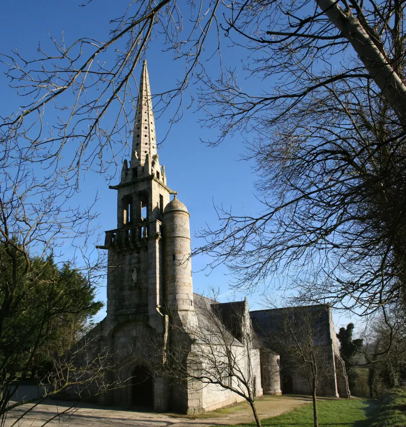
16e siècle ; 18e siècle Petit édifice en croix latine qui se compose d'une nef flanquée au nord d'un bas-côté, d'un transept et d'une abside polygonale. Sur le pignon de la façade occidentale s'élève un petit clocher ajouré, à flèche de pierre qui semble appartenir au 17e siècle. Les grandes fenêtres de la nef et de l'abside sont surmontées de pignons, avec rampants décorées de crochets et de gargouilles. Flèche reconstruite en 1757. A l'intérieur, la voûte est formée par une charpente lambrissée. Une clôture en bois peint et sculpté date du 16e siècle. Sur chacun des panneaux sont représentés les apôtres et deux scènes de la vie du Christ. L'entrait qui sépare la nef du transept porte en son milieu le Christ en croix entouré de sa mère et de Saint-Jean. ££Cette chapelle pourrait avoir été une fondation seigneuriale remontant aux premières années du 16e siècle. Sa proximité avec la forteresse de Tossen-Saint-Veltas laisse penser que ce pouvait être la chapelle privée de ce château. Cet édifice paraît avoir été totalement achevé en une seule campagne se situant autour de 1500, et fait partie des créations de l'atelier de Philippe de Beaumanoir, constructeur très actif en Trégor.
Map and restricted areas
Open in the main mapRestricted zones
Nearby aerodromes
Open aerodromes within 25 km of the spot, heliports included, with their distance and direction from the spot. Near an aerodrome, drone flying is prohibited or height-limited: check the UAS zones map.
No known open aerodrome within 25 km.
Aviation weather (METAR and TAF)
LFRU – Morlaix-Ploujean Airport MVFR
METAR
METAR LFRU 171330Z AUTO 24028G44KT 6000 -RA BKN028/// BKN039/// BKN046/// ///CB 14/10 Q0987
- Wind
- 240°, 52 km/h, gusts 81 km/h
- Visibility
- 6 km
- Weather
- Rain light
- Clouds
- Broken (5-7/8) at 2,800 ft (850 m) ; Broken (5-7/8) at 3,900 ft (1190 m) ; Broken (5-7/8) at 4,600 ft (1400 m)
- Temperature
- 14 °C, dew point 10 °C
- QNH
- 987 hPa
- Flight category
- MVFR: ceiling 1,000–3,000 ft or visibility 3–5 mi
TAF
Weather and Kp index
| Day | Weather | Temp. min. / max. | Wind | Rain | Max Kp |
|---|---|---|---|---|---|
| Tue 17 Nov | Heavy rain | 9° / 11° | 36 km/h SW | 5.4 mm | 5 |
| Wed 18 Nov | Showers | 8° / 12° | 31 km/h SW | 12 mm | 5 |
| Thu 19 Nov | Light rain | 8° / 11° | 32 km/h W | 3.9 mm | 3 |
| Fri 20 Nov | Showers | 8° / 11° | 32 km/h SW | 3.3 mm | 3 |
| Sat 21 Nov | Partly cloudy | 7° / 12° | 25 km/h SE | 3.4 mm | – |
| Sun 22 Nov | Light rain | 8° / 10° | 30 km/h SW | 10 mm | – |
| Mon 23 Nov | Partly cloudy | 5° / 12° | 21 km/h S | 1.8 mm | – |
Hour by hour: Tuesday 17 November
| Time | Weather | Temp. | Wind | Rain | Clouds | Kp |
|---|---|---|---|---|---|---|
| 15:00 | Heavy rain | 11° | 36 km/h SW | 3.8 mm | 100 % | 4 |
| 16:00 | Light rain | 11° | 33 km/h SW | 0.2 mm | 99 % | 4 |
| 17:00 | Showers | 11° | 30 km/h SW | 0.1 mm | 70 % | 4 |
| 18:00 | Partly cloudy | 10° | 28 km/h W | – | 41 % | 4 |
| 19:00 | Fair | 10° | 27 km/h W | – | 16 % | 5 |
| 20:00 | Fair | 10° | 26 km/h SW | – | 35 % | 5 |
| 21:00 | Showers | 10° | 28 km/h SW | 0.6 mm | 45 % | 5 |
| 22:00 | Showers | 9° | 31 km/h W | 0.4 mm | 73 % | 5 |
Hour by hour: Wednesday 18 November
| Time | Weather | Temp. | Wind | Rain | Clouds | Kp |
|---|---|---|---|---|---|---|
| 06:00 | Light rain | 9° | 27 km/h SW | 0.2 mm | 100 % | 4 |
| 07:00 | Light rain | 9° | 27 km/h SW | 0.1 mm | 95 % | 4 |
| 08:00 | Light rain | 9° | 26 km/h SW | 0.3 mm | 100 % | 4 |
| 09:00 | Showers | 10° | 27 km/h SW | 0.4 mm | 58 % | 4 |
| 10:00 | Showers | 10° | 27 km/h SW | 0.2 mm | 59 % | 4 |
| 11:00 | Fair | 10° | 26 km/h SW | – | 29 % | 4 |
| 12:00 | Showers | 12° | 26 km/h SW | 0.2 mm | 54 % | 4 |
| 13:00 | Showers | 12° | 26 km/h SW | 0.2 mm | 37 % | 3 |
| 14:00 | Showers | 12° | 28 km/h SW | 0.2 mm | 82 % | 3 |
| 15:00 | Cloudy | 12° | 31 km/h SW | – | 100 % | 3 |
| 16:00 | Rain | 12° | 28 km/h SW | 0.5 mm | 95 % | 3 |
| 17:00 | Heavy rain | 10° | 28 km/h SW | 1.3 mm | 99 % | 3 |
| 18:00 | Heavy rain | 10° | 27 km/h SW | 1.9 mm | 100 % | 3 |
| 19:00 | Light rain | 10° | 26 km/h S | 0.2 mm | 91 % | 2 |
| 20:00 | Rain | 10° | 29 km/h SW | 1.0 mm | 91 % | 2 |
| 21:00 | Heavy rain | 10° | 27 km/h SW | 3.0 mm | 94 % | 2 |
| 22:00 | Partly cloudy | 9° | 26 km/h SW | – | 78 % | 2 |
Sunrise and sunset
| Day | Dawn | Sunrise | Golden hour | Sunset | Dusk | Day length |
|---|---|---|---|---|---|---|
| Tue 17 Nov | 07:50 | 08:25 | 08:25–09:14 · 16:44–17:34 | 17:34 | 18:08 | 9 h 08 |
| Wed 18 Nov | 07:52 | 08:26 | 08:26–09:16 · 16:43–17:32 | 17:32 | 18:07 | 9 h 06 |
| Thu 19 Nov | 07:53 | 08:28 | 08:28–09:17 · 16:42–17:31 | 17:31 | 18:06 | 9 h 03 |
| Fri 20 Nov | 07:55 | 08:29 | 08:29–09:19 · 16:40–17:30 | 17:30 | 18:05 | 9 h 01 |
| Sat 21 Nov | 07:56 | 08:31 | 08:31–09:21 · 16:39–17:29 | 17:29 | 18:04 | 8 h 58 |
| Sun 22 Nov | 07:57 | 08:32 | 08:32–09:22 · 16:38–17:28 | 17:28 | 18:03 | 8 h 56 |
| Mon 23 Nov | 07:59 | 08:33 | 08:33–09:24 · 16:37–17:28 | 17:28 | 18:02 | 8 h 54 |


Reviews (0)
Log in to review this spot. Log in · Create a free account
No reviews yet. Share yours!