

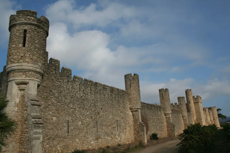
Grézan Castle
No reviews yet
Have you flown here? Share your experience with other pilots.
+ Write the first reviewHistory
4e quart 19e siècle Cet ancien terroir agricole situé à la limite nord de la plaine biterroise et des premiers contreforts montagneux, a été le siège d'une commanderie des chevaliers de Saint-Jean de Jérusalem avant de devenir domaine viticole au 19e siècle. Il est difficile de déterminer ce qui peut subsister du bâti ancien, repris entre 1820 et 1888 et complètement remodelé en 1890 par Gabriel de Mirepoix qui confie l'ensemble des travaux à l'architecte Louis Garros. Celui-ci réalise un projet regroupant la totalité des bâtiments d'exploitation, le logis des maîtres et les communs autour de la grande cour principale, le tout enserré dans une plus large enceinte en forme de courtine fortifiée avec crénelage, corps d'entrée et tourelles. Le traitement est néo-médiéval, inspiré pour les corps d'habitation des modèles néo-gothiques anglais. Le parc dessiné fait partie de la conception de l'ensemble. Dans la série des châteaux dus à la prospérité viticole du biterrois à la fin du 19e siècle, celui-ci se distingue par l'ampleur de son programme et son originalité se servant, notamment dans la décoration sculptée, du souvenir historique de la commanderie (remplois d'éléments anciens).
Map and restricted areas
Open in the main mapRestricted zones
| Zone | Category | Limits | Conditions |
|---|---|---|---|
| Istres | Zone réglementée | 5491 m above sea level → 30766 m above sea level | Vols interdits sauf lorsque the official document of the zone l'autorise explicitement ou avec l'accord du gestionnaire de la zone lorsqu'il est désigné par the official document of the zone |
| Istres | Zone réglementée | 5491 m above sea level → 30766 m above sea level | Vols interdits sauf lorsque the official document of the zone l'autorise explicitement ou avec l'accord du gestionnaire de la zone lorsqu'il est désigné par the official document of the zone |
| Zrt/zdt Lima 2 | ZRT/ZDT | FL 195 / FL 285 | SUP AIP 219/26 · Du mardi 20 octobre au jeudi 22 octobre 2026 |
Nearby aerodromes
Open aerodromes within 25 km of the spot, heliports included, with their distance and direction from the spot. Near an aerodrome, drone flying is prohibited or height-limited: check the UAS zones map.
| Aerodrome | Type | Distance | Elevation |
|---|---|---|---|
| Bédarieux La Tour Airfield | Aerodrome | 16 km N | 377 m |
| Hôpital Montimaran Heliport | Heliport | 19 km S | 54 m |
| Béziers-Vias Airport | Airport | 24 km SE | 17 m |
Aviation weather (METAR and TAF)
LFMU – Béziers-Vias Airport VFR
METAR
METAR LFMU 171400Z AUTO 22007KT 9999 -RA FEW008/// BKN100/// ///TCU 16/14 Q1004 NOSIG
- Wind
- 220°, 13 km/h
- Visibility
- 10 km or more
- Weather
- Rain light
- Clouds
- Few (1-2/8) at 800 ft (240 m) ; Broken (5-7/8) at 10,000 ft (3050 m)
- Temperature
- 16 °C, dew point 14 °C
- QNH
- 1004 hPa
- Flight category
- VFR: ceiling > 3,000 ft and visibility > 5 mi
TAF
TAF LFMU 170800Z 1709/1809 VRB04KT 9999 BKN013 BECMG 1709/1711 CAVOK TEMPO 1711/1718 -SHRA SCT050TCU TEMPO 1807/1809 -SHRA SCT050TCU
| Period (local time) | Change | Wind | Visibility | Weather | Clouds |
|---|---|---|---|---|---|
| 17/11 10:00 → 18/11 10:00 | Initial conditions | Variable, 7 km/h | 10 km or more | Broken (5-7/8) at 1,300 ft (400 m) | |
| 17/11 10:00 → 18/11 10:00 | Becoming | Variable, 7 km/h | 10 km or more | No significant weather | No significant cloud |
| 17/11 12:00 → 17/11 19:00 | Temporarily | Showers of rain light | Scattered (3-4/8) at 5,000 ft (1520 m) (towering cumulus) | ||
| 18/11 08:00 → 18/11 10:00 | Temporarily | Showers of rain light | Scattered (3-4/8) at 5,000 ft (1520 m) (towering cumulus) |
Weather and Kp index
Sunrise and sunset
| Day | Dawn | Sunrise | Golden hour | Sunset | Dusk | Day length |
|---|---|---|---|---|---|---|
| Tue 17 Nov | 07:13 | 07:43 | 07:43–08:27 · 16:37–17:21 | 17:21 | 17:52 | 9 h 37 |
| Wed 18 Nov | 07:14 | 07:45 | 07:45–08:28 · 16:36–17:20 | 17:20 | 17:51 | 9 h 35 |
| Thu 19 Nov | 07:15 | 07:46 | 07:46–08:30 · 16:35–17:19 | 17:19 | 17:50 | 9 h 33 |
| Fri 20 Nov | 07:16 | 07:47 | 07:47–08:31 · 16:34–17:18 | 17:18 | 17:50 | 9 h 31 |
| Sat 21 Nov | 07:17 | 07:48 | 07:48–08:33 · 16:34–17:18 | 17:18 | 17:49 | 9 h 29 |
| Sun 22 Nov | 07:18 | 07:50 | 07:50–08:34 · 16:33–17:17 | 17:17 | 17:48 | 9 h 27 |
| Mon 23 Nov | 07:20 | 07:51 | 07:51–08:35 · 16:32–17:16 | 17:16 | 17:48 | 9 h 25 |

Reviews (0)
Log in to review this spot. Log in · Create a free account
No reviews yet. Share yours!