

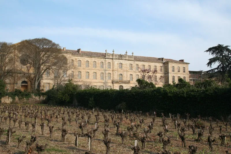
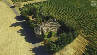
Former Priory known as Cassan "Castle"
No reviews yet
Have you flown here? Share your experience with other pilots.
+ Write the first reviewHistory
1ère moitié 12e siècle ; 14e siècle ; 2e moitié 17e siècle ; milieu 18e siècle Prieuré fondé au 11e siècle. Eglise consacrée en 1115. Bâtiment des Hôtes reconstruit et fortifié au 14e siècle. Au 17e siècle, transfert du prieuré aux génovéfains, puis restauration de l'église et des bâtiments anciens et reconstruction du corps de logis. Château édifié entre 1754 et 1758, peut-être par un des Giral. A partir du 18e siècle, diverses utilisations. Rachat par l'Etat en 1946. En 1994, une société privée a racheté l'édifice, souhaite le réhabiliter et l'ouvrir au public.
Map and restricted areas
Open in the main mapRestricted zones
| Zone | Category | Limits | Conditions |
|---|---|---|---|
| Istres | Zone réglementée | 919 m above sea level → 6259 m above sea level | Vols interdits sauf lorsque the official document of the zone l'autorise explicitement ou avec l'accord du gestionnaire de la zone lorsqu'il est désigné par the official document of the zone |
| Istres | Zone réglementée | 5491 m above sea level → 30766 m above sea level | Vols interdits sauf lorsque the official document of the zone l'autorise explicitement ou avec l'accord du gestionnaire de la zone lorsqu'il est désigné par the official document of the zone |
| Istres | Zone réglementée | 5491 m above sea level → 30766 m above sea level | Vols interdits sauf lorsque the official document of the zone l'autorise explicitement ou avec l'accord du gestionnaire de la zone lorsqu'il est désigné par the official document of the zone |
| Zrt/zdt Lima 2 | ZRT/ZDT | FL 195 / FL 285 | SUP AIP 219/26 · Du mardi 20 octobre au jeudi 22 octobre 2026 |
Nearby aerodromes
Open aerodromes within 25 km of the spot, heliports included, with their distance and direction from the spot. Near an aerodrome, drone flying is prohibited or height-limited: check the UAS zones map.
| Aerodrome | Type | Distance | Elevation |
|---|---|---|---|
| Bédarieux La Tour Airfield | Aerodrome | 19 km NW | 377 m |
| Hôpital Montimaran Heliport | Heliport | 19 km S | 54 m |
| Béziers-Vias Airport | Airport | 21 km S | 17 m |
Aviation weather (METAR and TAF)
LFMU – Béziers-Vias Airport VFR
METAR
METAR LFMU 171330Z AUTO 23009KT CAVOK 16/13 Q1005 TEMPO SCT050TCU
- Wind
- 230°, 17 km/h
- Visibility
- 10 km or more
- Clouds
- –
- Temperature
- 16 °C, dew point 13 °C
- QNH
- 1005 hPa
- Flight category
- VFR: ceiling > 3,000 ft and visibility > 5 mi
TAF
TAF LFMU 170800Z 1709/1809 VRB04KT 9999 BKN013 BECMG 1709/1711 CAVOK TEMPO 1711/1718 -SHRA SCT050TCU TEMPO 1807/1809 -SHRA SCT050TCU
| Period (local time) | Change | Wind | Visibility | Weather | Clouds |
|---|---|---|---|---|---|
| 17/11 10:00 → 18/11 10:00 | Initial conditions | Variable, 7 km/h | 10 km or more | Broken (5-7/8) at 1,300 ft (400 m) | |
| 17/11 10:00 → 18/11 10:00 | Becoming | Variable, 7 km/h | 10 km or more | No significant weather | No significant cloud |
| 17/11 12:00 → 17/11 19:00 | Temporarily | Showers of rain light | Scattered (3-4/8) at 5,000 ft (1520 m) (towering cumulus) | ||
| 18/11 08:00 → 18/11 10:00 | Temporarily | Showers of rain light | Scattered (3-4/8) at 5,000 ft (1520 m) (towering cumulus) |
Weather and Kp index
| Day | Weather | Temp. min. / max. | Wind | Rain | Max Kp |
|---|---|---|---|---|---|
| Tue 17 Nov | Light rain | 12° / 15° | 15 km/h SW | 3.0 mm | 5 |
| Wed 18 Nov | Fair | 11° / 17° | 23 km/h W | 0.6 mm | 5 |
| Thu 19 Nov | Fair | 11° / 15° | 30 km/h SW | 3.3 mm | 3 |
| Fri 20 Nov | Fair | 8° / 16° | 20 km/h SW | – | 3 |
| Sat 21 Nov | Cloudy | 9° / 16° | 6 km/h NE | 0.3 mm | – |
| Sun 22 Nov | Partly cloudy | 11° / 16° | 21 km/h NE | 0.4 mm | – |
| Mon 23 Nov | Cloudy | 9° / 15° | 10 km/h W | – | – |
Hour by hour: Tuesday 17 November
| Time | Weather | Temp. | Wind | Rain | Clouds | Kp |
|---|---|---|---|---|---|---|
| 15:00 | Light rain | 15° | 15 km/h SW | 0.2 mm | 100 % | 4 |
| 16:00 | Light rain | 15° | 15 km/h SW | 0.4 mm | 100 % | 4 |
| 17:00 | Rain | 14° | 10 km/h SW | 0.9 mm | 99 % | 4 |
| 18:00 | Rain | 14° | 4 km/h NW | 0.8 mm | 98 % | 4 |
| 19:00 | Light rain | 14° | 4 km/h N | 0.2 mm | 100 % | 5 |
| 20:00 | Cloudy | 13° | 8 km/h N | – | 93 % | 5 |
| 21:00 | Light rain | 12° | 13 km/h N | 0.3 mm | 98 % | 5 |
| 22:00 | Light rain | 12° | 13 km/h NW | 0.2 mm | 100 % | 5 |
Hour by hour: Wednesday 18 November
| Time | Weather | Temp. | Wind | Rain | Clouds | Kp |
|---|---|---|---|---|---|---|
| 06:00 | Cloudy | 12° | 13 km/h SW | – | 100 % | 4 |
| 07:00 | Cloudy | 13° | 11 km/h SW | – | 99 % | 4 |
| 08:00 | Light rain | 13° | 15 km/h SW | 0.4 mm | 99 % | 4 |
| 09:00 | Cloudy | 13° | 18 km/h SW | – | 99 % | 4 |
| 10:00 | Light rain | 14° | 22 km/h W | 0.2 mm | 100 % | 4 |
| 11:00 | Partly cloudy | 15° | 23 km/h W | – | 74 % | 4 |
| 12:00 | Partly cloudy | 16° | 22 km/h W | – | 47 % | 4 |
| 13:00 | Fair | 17° | 21 km/h W | – | 32 % | 3 |
| 14:00 | Partly cloudy | 17° | 18 km/h W | – | 56 % | 3 |
| 15:00 | Fair | 17° | 17 km/h W | – | 15 % | 3 |
| 16:00 | Fair | 17° | 15 km/h W | – | 19 % | 3 |
| 17:00 | Partly cloudy | 14° | 8 km/h W | – | 57 % | 3 |
| 18:00 | Partly cloudy | 13° | 8 km/h SW | – | 66 % | 3 |
| 19:00 | Partly cloudy | 12° | 9 km/h SW | – | 74 % | 2 |
| 20:00 | Partly cloudy | 11° | 9 km/h W | – | 95 % | 2 |
| 21:00 | Partly cloudy | 11° | 5 km/h W | – | 95 % | 2 |
| 22:00 | Cloudy | 11° | 4 km/h W | – | 99 % | 2 |
Sunrise and sunset
| Day | Dawn | Sunrise | Golden hour | Sunset | Dusk | Day length |
|---|---|---|---|---|---|---|
| Tue 17 Nov | 07:12 | 07:43 | 07:43–08:27 · 16:37–17:21 | 17:21 | 17:51 | 9 h 37 |
| Wed 18 Nov | 07:13 | 07:44 | 07:44–08:28 · 16:36–17:20 | 17:20 | 17:51 | 9 h 35 |
| Thu 19 Nov | 07:15 | 07:46 | 07:46–08:29 · 16:35–17:19 | 17:19 | 17:50 | 9 h 33 |
| Fri 20 Nov | 07:16 | 07:47 | 07:47–08:31 · 16:34–17:18 | 17:18 | 17:49 | 9 h 31 |
| Sat 21 Nov | 07:17 | 07:48 | 07:48–08:32 · 16:33–17:17 | 17:17 | 17:49 | 9 h 29 |
| Sun 22 Nov | 07:18 | 07:49 | 07:49–08:34 · 16:32–17:17 | 17:17 | 17:48 | 9 h 27 |
| Mon 23 Nov | 07:19 | 07:51 | 07:51–08:35 · 16:31–17:16 | 17:16 | 17:47 | 9 h 25 |
Reviews (0)
Log in to review this spot. Log in · Create a free account
No reviews yet. Share yours!