

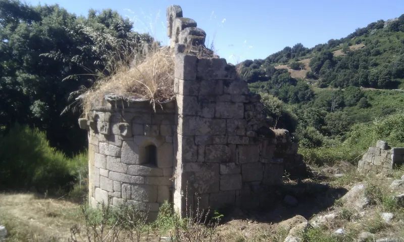
San Pietro di Panicali Chapel
No reviews yet
Have you flown here? Share your experience with other pilots.
+ Write the first reviewHistory
12e siècle La chapelle possède une nef unique orientée d'ouest en est et se termine par une abside semi-circulaire voûtée en cul de four. La nef est ruinée. Seuls l'abside et le pignon oriental sont conservés. L'abside conserve son décor d'arcatures aveugles surmontées d'une cordelière simulant un chaînage et reposant sur neuf modillons sculptés en haut relief et en méplat. Cet édifice est l'un des rares témoins de l'art roman dans la vallée du Taravo.
Map and restricted areas
Open in the main mapRestricted zones
| Zone | Category | Limits | Conditions |
|---|---|---|---|
| Tma Ajaccio |
Région de contrôle terminal | 305 m above ground level → 3821 m above sea level · 610 m above ground level → 3821 m above sea level · 610 m above ground level → 3821 m above sea level · 762 m above sea level → 3821 m above sea level · 762 m above sea level → 3821 m above sea level · 1676 m above sea level → 3821 m above sea level · 1676 m above sea level → 3821 m above sea level · 2138 m above sea level → 3821 m above sea level | Drone flights inside this zone are forbidden without the prior agreement of air traffic control |
| Zena Med | Zone dangereuse | 5491 m above sea level → 9003 m above sea level | Vols interdits sauf lorsque the official document of the zone l'autorise explicitement ou avec l'accord du gestionnaire de la zone lorsqu'il est désigné par the official document of the zone |
| Zrt Novembre | ZRT | FL 205 / FL 305 | SUP AIP 219/26 · Du mardi 20 octobre au jeudi 22 octobre 2026 |
Nearby aerodromes
Open aerodromes within 25 km of the spot, heliports included, with their distance and direction from the spot. Near an aerodrome, drone flying is prohibited or height-limited: check the UAS zones map.
| Aerodrome | Type | Distance | Elevation |
|---|---|---|---|
| Ajaccio-Napoléon Bonaparte Airport | Airport | 18 km NW | 5 m |
| Propriano Airport | Aerodrome | 23 km S | 4 m |
Aviation weather (METAR and TAF)
LFKJ – Ajaccio-Napoléon Bonaparte Airport MVFR
METAR
METAR LFKJ 171400Z AUTO 21011KT 9000 BKN023/// BKN032/// BKN041/// ///TCU 20/18 Q1008 NOSIG
- Wind
- 210°, 20 km/h
- Visibility
- 9 km
- Clouds
- Broken (5-7/8) at 2,300 ft (700 m) ; Broken (5-7/8) at 3,200 ft (980 m) ; Broken (5-7/8) at 4,100 ft (1250 m)
- Temperature
- 20 °C, dew point 18 °C
- QNH
- 1008 hPa
- Flight category
- MVFR: ceiling 1,000–3,000 ft or visibility 3–5 mi
TAF
TAF LFKJ 170800Z 1709/1809 VRB05KT 9999 BKN020 BECMG 1709/1710 22014KT TEMPO 1709/1724 -SHRA SCT020TCU BECMG 1722/1724 VRB02KT
| Period (local time) | Change | Wind | Visibility | Weather | Clouds |
|---|---|---|---|---|---|
| 17/11 10:00 → 18/11 10:00 | Initial conditions | Variable, 9 km/h | 10 km or more | Broken (5-7/8) at 2,000 ft (610 m) | |
| 17/11 10:00 → 18/11 01:00 | Temporarily | Showers of rain light | Scattered (3-4/8) at 2,000 ft (610 m) (towering cumulus) | ||
| 17/11 10:00 → 17/11 23:00 | Becoming | 220°, 26 km/h | 10 km or more | Broken (5-7/8) at 2,000 ft (610 m) | |
| 17/11 23:00 → 18/11 10:00 | Becoming | Variable, 4 km/h | 10 km or more | Broken (5-7/8) at 2,000 ft (610 m) |
Weather and Kp index
| Day | Weather | Temp. min. / max. | Wind | Rain | Max Kp |
|---|---|---|---|---|---|
| Tue 17 Nov | Rain | 15° / 16° | 27 km/h W | 7.7 mm | 5 |
| Wed 18 Nov | Fair | 12° / 18° | 28 km/h W | 6.5 mm | 5 |
| Thu 19 Nov | Partly cloudy | 10° / 17° | 31 km/h W | 41 mm | 3 |
| Fri 20 Nov | Partly cloudy | 8° / 14° | 27 km/h N | 3.9 mm | 3 |
| Sat 21 Nov | Partly cloudy | 11° / 14° | 15 km/h NW | 3.6 mm | – |
| Sun 22 Nov | Rain | 10° / 14° | 10 km/h NW | 6.4 mm | – |
| Mon 23 Nov | Cloudy | 10° / 14° | 20 km/h NW | – | – |
Hour by hour: Tuesday 17 November
| Time | Weather | Temp. | Wind | Rain | Clouds | Kp |
|---|---|---|---|---|---|---|
| 15:00 | Rain | 16° | 24 km/h W | 0.5 mm | 100 % | 4 |
| 16:00 | Rain | 15° | 25 km/h W | 0.6 mm | 100 % | 4 |
| 17:00 | Heavy rain | 15° | 25 km/h W | 1.2 mm | 100 % | 4 |
| 18:00 | Heavy rain | 15° | 25 km/h W | 1.7 mm | 100 % | 4 |
| 19:00 | Heavy rain | 15° | 24 km/h W | 1.6 mm | 100 % | 5 |
| 20:00 | Rain | 15° | 24 km/h W | 0.7 mm | 100 % | 5 |
| 21:00 | Light rain | 16° | 24 km/h W | 0.2 mm | 100 % | 5 |
| 22:00 | Rain | 16° | 25 km/h W | 0.7 mm | 100 % | 5 |
Hour by hour: Wednesday 18 November
| Time | Weather | Temp. | Wind | Rain | Clouds | Kp |
|---|---|---|---|---|---|---|
| 06:00 | Fog | 15° | 19 km/h NW | – | 98 % | 4 |
| 07:00 | Fog | 15° | 17 km/h W | – | 91 % | 4 |
| 08:00 | Fog | 15° | 16 km/h W | – | 98 % | 4 |
| 09:00 | Light rain | 15° | 17 km/h W | 0.1 mm | 95 % | 4 |
| 10:00 | Showers | 16° | 19 km/h W | 0.2 mm | 71 % | 4 |
| 11:00 | Showers | 17° | 21 km/h W | 0.1 mm | 41 % | 4 |
| 12:00 | Partly cloudy | 17° | 22 km/h W | – | 39 % | 4 |
| 13:00 | Fair | 18° | 23 km/h W | – | 25 % | 3 |
| 14:00 | Clear sky | 17° | 23 km/h W | – | 12 % | 3 |
| 15:00 | Clear sky | 17° | 22 km/h NW | – | 11 % | 3 |
| 16:00 | Fair | 16° | 19 km/h NW | – | 23 % | 3 |
| 17:00 | Fair | 15° | 15 km/h NW | – | 23 % | 3 |
| 18:00 | Partly cloudy | 14° | 15 km/h NW | – | 38 % | 3 |
| 19:00 | Partly cloudy | 14° | 16 km/h NW | – | 47 % | 2 |
| 20:00 | Partly cloudy | 14° | 17 km/h NW | – | 75 % | 2 |
| 21:00 | Partly cloudy | 13° | 17 km/h NW | – | 62 % | 2 |
| 22:00 | Partly cloudy | 13° | 16 km/h NW | – | 49 % | 2 |
Sunrise and sunset
| Day | Dawn | Sunrise | Golden hour | Sunset | Dusk | Day length |
|---|---|---|---|---|---|---|
| Tue 17 Nov | 06:46 | 07:16 | 07:16–07:58 · 16:20–17:02 | 17:02 | 17:32 | 9 h 46 |
| Wed 18 Nov | 06:47 | 07:17 | 07:17–07:59 · 16:19–17:01 | 17:01 | 17:31 | 9 h 44 |
| Thu 19 Nov | 06:48 | 07:18 | 07:18–08:01 · 16:18–17:00 | 17:00 | 17:31 | 9 h 42 |
| Fri 20 Nov | 06:49 | 07:20 | 07:20–08:02 · 16:17–17:00 | 17:00 | 17:30 | 9 h 40 |
| Sat 21 Nov | 06:50 | 07:21 | 07:21–08:03 · 16:16–16:59 | 16:59 | 17:29 | 9 h 38 |
| Sun 22 Nov | 06:52 | 07:22 | 07:22–08:05 · 16:16–16:58 | 16:58 | 17:29 | 9 h 36 |
| Mon 23 Nov | 06:53 | 07:23 | 07:23–08:06 · 16:15–16:58 | 16:58 | 17:28 | 9 h 34 |

Reviews (0)
Log in to review this spot. Log in · Create a free account
No reviews yet. Share yours!