

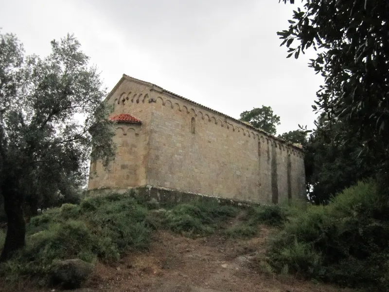
Former Saint John Church
No reviews yet
Have you flown here? Share your experience with other pilots.
+ Write the first reviewHistory
12e siècle La piève d'Attala était un ensemble d'habitations éparses desservies par cette église, construction romane abandonnée. La construction de cet édifice peut remonter au 12e siècle, sans doute à l'époque de la domination pisane. La nef se termine à l'est par une abside circulaire. Les murs sont en granit rose et reposent sur le roc par un soubassement terminé en glacis. A l'ouest, la porte principale présente un linteau reposant sur deux corbeaux sculptés servant d'appui à un tympan aveugle en plein cintre orné d'un boudin torsadé. Les murs goutterots de la nef et de l'abside sont couronnés par une arcature bien appareillée, reposant sur des corbeaux moulurés ou ornés de crochets. Les arcatures des façades latérales de la nef se retournent sur la façade principale, au-dessus d'un fronton orné de chaque côté de trois petites arcades et, au centre, d'une arcade plus grande renfermant une petite baie cruciforme. Quelques arcades de la façade sud et de la façade principale présentent des cavités circulaires. Ces cavités contenaient des plats en terre cuite émaillée. L'abside a conservé sa voûte en cul de four.
Map and restricted areas
Open in the main mapRestricted zones
| Zone | Category | Limits | Conditions |
|---|---|---|---|
| Zena Med | Zone dangereuse | 5491 m above sea level → 9003 m above sea level | Vols interdits sauf lorsque the official document of the zone l'autorise explicitement ou avec l'accord du gestionnaire de la zone lorsqu'il est désigné par the official document of the zone |
| Zrt Novembre | ZRT | FL 205 / FL 305 | SUP AIP 219/26 · Du mardi 20 octobre au jeudi 22 octobre 2026 |
Nearby aerodromes
Open aerodromes within 25 km of the spot, heliports included, with their distance and direction from the spot. Near an aerodrome, drone flying is prohibited or height-limited: check the UAS zones map.
| Aerodrome | Type | Distance | Elevation |
|---|---|---|---|
| Propriano Airport | Aerodrome | 14 km W | 4 m |
| Figari Sud-Corse Airport | Airport | 23 km S | 26 m |
| Helisudcorse | Heliport | 23 km SE | 4 m |
Aviation weather (METAR and TAF)
LFKF – Figari Sud-Corse Airport MVFR
METAR
METAR LFKF 171330Z AUTO 24019KT 9999 SCT018/// BKN026/// OVC032/// ///TCU 21/17 Q1009 TEMPO BECMG 25020G35KT
- Wind
- 240°, 35 km/h
- Visibility
- 10 km or more
- Clouds
- Scattered (3-4/8) at 1,800 ft (550 m) ; Broken (5-7/8) at 2,600 ft (790 m) ; Overcast (8/8) at 3,200 ft (980 m)
- Temperature
- 21 °C, dew point 17 °C
- QNH
- 1009 hPa
- Flight category
- MVFR: ceiling 1,000–3,000 ft or visibility 3–5 mi
TAF
TAF LFKF 170800Z 1709/1809 25020G35KT 9999 BKN020 TEMPO 1709/1724 -SHRA SCT020TCU PROB30 TEMPO 1718/1724 26025G45KT
| Period (local time) | Change | Wind | Visibility | Weather | Clouds |
|---|---|---|---|---|---|
| 17/11 10:00 → 18/11 10:00 | Initial conditions | 250°, 37 km/h, gusts 65 km/h | 10 km or more | Broken (5-7/8) at 2,000 ft (610 m) | |
| 17/11 10:00 → 18/11 01:00 | Temporarily | Showers of rain light | Scattered (3-4/8) at 2,000 ft (610 m) (towering cumulus) | ||
| 17/11 19:00 → 18/11 01:00 | Temporarily, probability 30% | 260°, 46 km/h, gusts 83 km/h |
Weather and Kp index
Sunrise and sunset
| Day | Dawn | Sunrise | Golden hour | Sunset | Dusk | Day length |
|---|---|---|---|---|---|---|
| Tue 17 Nov | 06:45 | 07:15 | 07:15–07:57 · 16:20–17:02 | 17:02 | 17:32 | 9 h 46 |
| Wed 18 Nov | 06:47 | 07:17 | 07:17–07:59 · 16:19–17:01 | 17:01 | 17:31 | 9 h 44 |
| Thu 19 Nov | 06:48 | 07:18 | 07:18–08:00 · 16:18–17:01 | 17:01 | 17:31 | 9 h 42 |
| Fri 20 Nov | 06:49 | 07:19 | 07:19–08:01 · 16:18–17:00 | 17:00 | 17:30 | 9 h 40 |
| Sat 21 Nov | 06:50 | 07:20 | 07:20–08:02 · 16:17–16:59 | 16:59 | 17:29 | 9 h 39 |
| Sun 22 Nov | 06:51 | 07:21 | 07:21–08:04 · 16:16–16:59 | 16:59 | 17:29 | 9 h 37 |
| Mon 23 Nov | 06:52 | 07:22 | 07:22–08:05 · 16:15–16:58 | 16:58 | 17:28 | 9 h 35 |


Reviews (0)
Log in to review this spot. Log in · Create a free account
No reviews yet. Share yours!