

Tholet Castle
No reviews yet
Have you flown here? Share your experience with other pilots.
+ Write the first reviewHistory
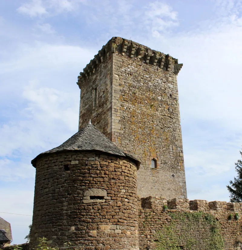
13e siècle ; 16e siècle ; 19e siècle L'accès se fait par un porche daté de 1800, donnant accès à une grande cour de ferme dans laquelle se trouve l'ancien donjon et le logis actuel avec sa tourelle du début du 16e siècle. Le donjon est une grosse tour carrée percée de quelques ouvertures. L'accès se faire au premier étage, formé d'une grande salle voûtée d'ogive et conservant une grande cheminée. La construction est en grès rouge et jaune. Mâchicoulis et chemin de ronde. A côté du donjon, la ferme est constituée de bâtiments hétéroclites. La tourelle d'escalier est reliée au logis Renaissance par un bâtiment du 19e siècle. Le logis est percé de fenêtres à meneaux et traverses. Il possède quelques parties en encorbellement sur des corbeaux. Le donjon et la ferme sont enserrés dans une enceinte dont il reste une tour ronde près du donjon, une partie de courtine percée de meurtrières et une autre tour en partie ruinée. Au sud de cette première enceinte s'en étendait une seconde avec deux tours aux angles.
Map and restricted areas
Open in the main mapRestricted zones
| Zone | Category | Limits | Conditions |
|---|---|---|---|
| Zrt Echo Low | ZRT | From the ground up to about 4,100 m above sea level | SUP AIP 219/26 · Du mardi 20 octobre au jeudi 22 octobre 2026 |
| Zrt Echo | ZRT | FL 195 / FL 235 | SUP AIP 219/26 · Du mardi 20 octobre au jeudi 22 octobre 2026 |
Nearby aerodromes
Open aerodromes within 25 km of the spot, heliports included, with their distance and direction from the spot. Near an aerodrome, drone flying is prohibited or height-limited: check the UAS zones map.
| Aerodrome | Type | Distance | Elevation |
|---|---|---|---|
| Centre Hospitalier Heliport | Heliport | 21 km SW | 595 m |
| Rodez-Marcillac Airport | Airport | 24 km W | 582 m |
Aviation weather (METAR and TAF)
LFCR – Rodez-Marcillac Airport IFR
METAR
METAR LFCR 171400Z AUTO 24006KT 9999 OVC009/// ///CB 12/11 Q1005 TEMPO BKN011
- Wind
- 240°, 11 km/h
- Visibility
- 10 km or more
- Clouds
- Overcast (8/8) at 900 ft (270 m)
- Temperature
- 12 °C, dew point 11 °C
- QNH
- 1005 hPa
- Flight category
- IFR: ceiling 500–1,000 ft or visibility 1–3 mi
TAF
TAF AMD LFCR 171416Z 1714/1812 23010KT 9999 BKN018 TEMPO 1714/1717 -RA BKN009 TEMPO 1720/1803 3000 -RADZ BKN005 BKN011 TEMPO 1803/1808 3000 RA BKN006 TEMPO 1803/1806 27015G28KT TEMPO 1808/1811 BKN008 TEMPO 1811/1812 26015G28KT 4000 SHRA BKN017TCU
| Period (local time) | Change | Wind | Visibility | Weather | Clouds |
|---|---|---|---|---|---|
| 17/11 15:00 → 18/11 13:00 | Initial conditions | 230°, 19 km/h | 10 km or more | Broken (5-7/8) at 1,800 ft (550 m) | |
| 17/11 15:00 → 17/11 18:00 | Temporarily | Rain light | Broken (5-7/8) at 900 ft (270 m) | ||
| 17/11 21:00 → 18/11 04:00 | Temporarily | 3.0 km | Rain light ; drizzle light | Broken (5-7/8) at 500 ft (150 m) ; Broken (5-7/8) at 1,100 ft (340 m) | |
| 18/11 04:00 → 18/11 09:00 | Temporarily | 3.0 km | Rain | Broken (5-7/8) at 600 ft (180 m) | |
| 18/11 04:00 → 18/11 07:00 | Temporarily | 270°, 28 km/h, gusts 52 km/h | |||
| 18/11 09:00 → 18/11 12:00 | Temporarily | Broken (5-7/8) at 800 ft (240 m) | |||
| 18/11 12:00 → 18/11 13:00 | Temporarily | 260°, 28 km/h, gusts 52 km/h | 4.0 km | Showers of rain | Broken (5-7/8) at 1,700 ft (520 m) (towering cumulus) |
Weather and Kp index
Sunrise and sunset
| Day | Dawn | Sunrise | Golden hour | Sunset | Dusk | Day length |
|---|---|---|---|---|---|---|
| Tue 17 Nov | 07:16 | 07:48 | 07:48–08:32 · 16:36–17:20 | 17:20 | 17:51 | 9 h 32 |
| Wed 18 Nov | 07:17 | 07:49 | 07:49–08:34 · 16:34–17:19 | 17:19 | 17:51 | 9 h 30 |
| Thu 19 Nov | 07:19 | 07:50 | 07:50–08:35 · 16:33–17:18 | 17:18 | 17:50 | 9 h 27 |
| Fri 20 Nov | 07:20 | 07:52 | 07:52–08:37 · 16:32–17:17 | 17:17 | 17:49 | 9 h 25 |
| Sat 21 Nov | 07:21 | 07:53 | 07:53–08:38 · 16:31–17:17 | 17:17 | 17:48 | 9 h 23 |
| Sun 22 Nov | 07:22 | 07:54 | 07:54–08:39 · 16:31–17:16 | 17:16 | 17:48 | 9 h 21 |
| Mon 23 Nov | 07:23 | 07:55 | 07:55–08:41 · 16:30–17:15 | 17:15 | 17:47 | 9 h 19 |

Reviews (0)
Log in to review this spot. Log in · Create a free account
No reviews yet. Share yours!