

Bourines Castle and its Outbuildings
No reviews yet
Have you flown here? Share your experience with other pilots.
+ Write the first reviewHistory
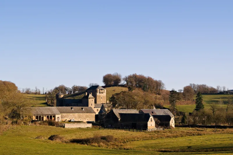
13e siècle ; 14e siècle ; 15e siècle En 1273, la terre et son château ont été donnés par les comtes de Rodez à la maison d'Aubrac. Ancienne demeure fortifiée féodale, demeure du cardinal d'Armagnac, dont l'appareil militaire a sans doute été amputé de divers éléments, mais dont l'essentiel des dispositions demeure. Les dispositions d'origine se lisent parfaitement. Le château était composé d'un donjon rectangulaire du 13e siècle, remanié au 14e, et d'un corps de logis accolé sur sa face ouest, un mur de courtine flanqué de quatre tours d'angle délimitant une cour intérieure. Dans son état actuel, l'ensemble date du 14e siècle. Des aménagements datent du cardinal d'Armagnac, tels que le portail portant une inscription datée de 1546, et la galerie intérieure. Chapelle du 15e siècle voûtée en ogive. Les salles intérieures ont conservé leur poutraison et cheminée, ainsi que certaines pièces de mobilier. Devant la façade nord du château se trouve une croix de carrefour, datée de 1579.
Map and restricted areas
Open in the main mapRestricted zones
| Zone | Category | Limits | Conditions |
|---|---|---|---|
| Zrt Echo Low | ZRT | From the ground up to about 4,100 m above sea level | SUP AIP 219/26 · Du mardi 20 octobre au jeudi 22 octobre 2026 |
| Zrt Echo | ZRT | FL 195 / FL 235 | SUP AIP 219/26 · Du mardi 20 octobre au jeudi 22 octobre 2026 |
Nearby aerodromes
Open aerodromes within 25 km of the spot, heliports included, with their distance and direction from the spot. Near an aerodrome, drone flying is prohibited or height-limited: check the UAS zones map.
| Aerodrome | Type | Distance | Elevation |
|---|---|---|---|
| Centre Hospitalier Heliport | Heliport | 22 km W | 595 m |
| Base Hydro-ULM du Barrage de Pareloup | Seaplane base | 24 km S | 803 m |
Aviation weather (METAR and TAF)
LFCR – Rodez-Marcillac Airport IFR
METAR
METAR LFCR 171330Z AUTO 19005KT 170V230 9999 OVC009 13/11 Q1005 TEMPO BKN011
- Wind
- 190°, 9 km/h
- Visibility
- 10 km or more
- Clouds
- Overcast (8/8) at 900 ft (270 m)
- Temperature
- 13 °C, dew point 11 °C
- QNH
- 1005 hPa
- Flight category
- IFR: ceiling 500–1,000 ft or visibility 1–3 mi
TAF
TAF LFCR 171100Z 1712/1812 23010KT 9999 BKN018 TEMPO 1712/1717 -RA BKN011 TEMPO 1712/1714 4000 RA BKN005 TEMPO 1720/1803 3000 -RADZ BKN005 BKN011 TEMPO 1803/1808 3000 RA BKN006 TEMPO 1803/1806 27015G28KT TEMPO 1808/1811 BKN008 TEMPO 1811/1812 26015G28KT 4000 SHRA BKN017TCU
| Period (local time) | Change | Wind | Visibility | Weather | Clouds |
|---|---|---|---|---|---|
| 17/11 13:00 → 18/11 13:00 | Initial conditions | 230°, 19 km/h | 10 km or more | Broken (5-7/8) at 1,800 ft (550 m) | |
| 17/11 13:00 → 17/11 18:00 | Temporarily | Rain light | Broken (5-7/8) at 1,100 ft (340 m) | ||
| 17/11 13:00 → 17/11 15:00 | Temporarily | 4.0 km | Rain | Broken (5-7/8) at 500 ft (150 m) | |
| 17/11 21:00 → 18/11 04:00 | Temporarily | 3.0 km | Rain light ; drizzle light | Broken (5-7/8) at 500 ft (150 m) ; Broken (5-7/8) at 1,100 ft (340 m) | |
| 18/11 04:00 → 18/11 09:00 | Temporarily | 3.0 km | Rain | Broken (5-7/8) at 600 ft (180 m) | |
| 18/11 04:00 → 18/11 07:00 | Temporarily | 270°, 28 km/h, gusts 52 km/h | |||
| 18/11 09:00 → 18/11 12:00 | Temporarily | Broken (5-7/8) at 800 ft (240 m) | |||
| 18/11 12:00 → 18/11 13:00 | Temporarily | 260°, 28 km/h, gusts 52 km/h | 4.0 km | Showers of rain | Broken (5-7/8) at 1,700 ft (520 m) (towering cumulus) |
Weather and Kp index
| Day | Weather | Temp. min. / max. | Wind | Rain | Max Kp |
|---|---|---|---|---|---|
| Tue 17 Nov | Rain | 10° / 12° | 21 km/h W | 9.8 mm | 5 |
| Wed 18 Nov | Showers | 8° / 13° | 31 km/h W | 3.2 mm | 5 |
| Thu 19 Nov | Showers | 7° / 11° | 31 km/h W | 27 mm | 3 |
| Fri 20 Nov | Light rain | 7° / 10° | 30 km/h W | 6.4 mm | 3 |
| Sat 21 Nov | Fair | 8° / 12° | 14 km/h W | 0.1 mm | – |
| Sun 22 Nov | Showers | 7° / 10° | 26 km/h W | 8.8 mm | – |
| Mon 23 Nov | Cloudy | 5° / 9° | 19 km/h W | 0.6 mm | – |
Hour by hour: Tuesday 17 November
| Time | Weather | Temp. | Wind | Rain | Clouds | Kp |
|---|---|---|---|---|---|---|
| 15:00 | Rain | 12° | 14 km/h SW | 0.6 mm | 100 % | 4 |
| 16:00 | Heavy rain | 11° | 12 km/h SW | 1.3 mm | 100 % | 4 |
| 17:00 | Heavy rain | 11° | 12 km/h SW | 1.2 mm | 100 % | 4 |
| 18:00 | Heavy rain | 10° | 12 km/h SW | 1.8 mm | 100 % | 4 |
| 19:00 | Heavy rain | 10° | 10 km/h SW | 2.6 mm | 100 % | 5 |
| 20:00 | Heavy rain | 10° | 13 km/h SW | 1.1 mm | 100 % | 5 |
| 21:00 | Light rain | 10° | 17 km/h SW | 0.4 mm | 100 % | 5 |
| 22:00 | Rain | 10° | 21 km/h W | 0.5 mm | 100 % | 5 |
Hour by hour: Wednesday 18 November
| Time | Weather | Temp. | Wind | Rain | Clouds | Kp |
|---|---|---|---|---|---|---|
| 06:00 | Cloudy | 10° | 27 km/h W | – | 100 % | 4 |
| 07:00 | Cloudy | 10° | 24 km/h W | – | 93 % | 4 |
| 08:00 | Cloudy | 10° | 26 km/h W | – | 99 % | 4 |
| 09:00 | Light rain | 10° | 28 km/h W | 0.1 mm | 93 % | 4 |
| 10:00 | Fair | 11° | 26 km/h W | – | 30 % | 4 |
| 11:00 | Showers | 12° | 26 km/h W | 0.1 mm | 35 % | 4 |
| 12:00 | Showers | 12° | 27 km/h W | 0.1 mm | 19 % | 4 |
| 13:00 | Showers | 13° | 23 km/h W | 0.2 mm | 56 % | 3 |
| 14:00 | Showers | 12° | 24 km/h W | 0.3 mm | 80 % | 3 |
| 15:00 | Showers | 11° | 24 km/h W | 0.1 mm | 38 % | 3 |
| 16:00 | Fair | 11° | 21 km/h W | – | 33 % | 3 |
| 17:00 | Fair | 11° | 19 km/h W | – | 27 % | 3 |
| 18:00 | Partly cloudy | 10° | 15 km/h W | – | 69 % | 3 |
| 19:00 | Cloudy | 8° | 12 km/h SW | – | 99 % | 2 |
| 20:00 | Cloudy | 8° | 10 km/h S | – | 94 % | 2 |
| 21:00 | Cloudy | 8° | 10 km/h SE | – | 97 % | 2 |
| 22:00 | Cloudy | 8° | 14 km/h SE | – | 100 % | 2 |
Sunrise and sunset
| Day | Dawn | Sunrise | Golden hour | Sunset | Dusk | Day length |
|---|---|---|---|---|---|---|
| Tue 17 Nov | 07:16 | 07:47 | 07:47–08:32 · 16:36–17:20 | 17:20 | 17:51 | 9 h 32 |
| Wed 18 Nov | 07:17 | 07:49 | 07:49–08:33 · 16:34–17:19 | 17:19 | 17:51 | 9 h 30 |
| Thu 19 Nov | 07:18 | 07:50 | 07:50–08:35 · 16:33–17:18 | 17:18 | 17:50 | 9 h 28 |
| Fri 20 Nov | 07:20 | 07:51 | 07:51–08:36 · 16:32–17:17 | 17:17 | 17:49 | 9 h 26 |
| Sat 21 Nov | 07:21 | 07:53 | 07:53–08:38 · 16:31–17:17 | 17:17 | 17:48 | 9 h 23 |
| Sun 22 Nov | 07:22 | 07:54 | 07:54–08:39 · 16:31–17:16 | 17:16 | 17:48 | 9 h 21 |
| Mon 23 Nov | 07:23 | 07:55 | 07:55–08:41 · 16:30–17:15 | 17:15 | 17:47 | 9 h 19 |


Reviews (0)
Log in to review this spot. Log in · Create a free account
No reviews yet. Share yours!