

Tourist site
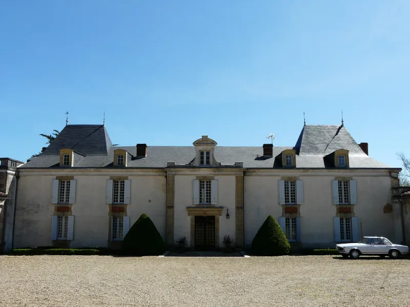
La Pommerie Castle
No reviews yet
Have you flown here? Share your experience with other pilots.
+ Write the first reviewHistory
4e quart 18e siècle ; milieu 19e siècle Château édifié à la fin du 18e siècle et réaménagé au 19e (façade nord). En 1999, ouverture d'un musée consacré à l'époque napoléonienne.
Map and restricted areas
Open in the main mapRestricted zones
| Zone | Category | Limits | Conditions |
|---|---|---|---|
| Zena Perigord Low | ZRT | FL 165 / FL 195 | SUP AIP 062/26 · Du jeudi 23 avril 2026 au jeudi 25 mars 2027 |
| Zena Perigord Medium | ZRT | FL 195 / FL 245 | SUP AIP 062/26 · Du jeudi 23 avril 2026 au jeudi 25 mars 2027 |
| Zena Perigord High | ZRT | FL 395 / UNL | SUP AIP 062/26 · Du jeudi 23 avril 2026 au jeudi 25 mars 2027 |
Nearby aerodromes
Open aerodromes within 25 km of the spot, heliports included, with their distance and direction from the spot. Near an aerodrome, drone flying is prohibited or height-limited: check the UAS zones map.
| Aerodrome | Type | Distance | Elevation |
|---|---|---|---|
| Pressignac Vicq Rebeyrotte | Aerodrome | 11 km SW | 196 m |
| Aérodrome de Belvès Saint-Pardoux | Aerodrome | 23 km SE | 241 m |
| Périgueux-Bassillac Airport | Airport | 25 km N | 100 m |
Aviation weather (METAR and TAF)
LFBX – Périgueux-Bassillac Airport VFR
METAR
METAR LFBX 171330Z AUTO 23007KT 150V260 9999 FEW037 BKN110 17/12 Q1002
- Wind
- 230°, 13 km/h
- Visibility
- 10 km or more
- Clouds
- Few (1-2/8) at 3,700 ft (1130 m) ; Broken (5-7/8) at 11,000 ft (3350 m)
- Temperature
- 17 °C, dew point 12 °C
- QNH
- 1002 hPa
- Flight category
- VFR: ceiling > 3,000 ft and visibility > 5 mi
TAF
Weather and Kp index
| Day | Weather | Temp. min. / max. | Wind | Rain | Max Kp |
|---|---|---|---|---|---|
| Tue 17 Nov | Light rain | 12° / 15° | 23 km/h SW | 4.7 mm | 5 |
| Wed 18 Nov | Showers | 11° / 14° | 27 km/h SW | 17 mm | 5 |
| Thu 19 Nov | Showers | 9° / 12° | 30 km/h SW | 17 mm | 3 |
| Fri 20 Nov | Rain | 8° / 12° | 21 km/h SW | 10.0 mm | 3 |
| Sat 21 Nov | Partly cloudy | 8° / 14° | 13 km/h E | 3.0 mm | – |
| Sun 22 Nov | Showers | 10° / 14° | 26 km/h W | 5.8 mm | – |
| Mon 23 Nov | Cloudy | 6° / 13° | 11 km/h SW | 0.2 mm | – |
Hour by hour: Tuesday 17 November
| Time | Weather | Temp. | Wind | Rain | Clouds | Kp |
|---|---|---|---|---|---|---|
| 15:00 | Light rain | 15° | 21 km/h SW | 0.1 mm | 99 % | 4 |
| 16:00 | Light rain | 14° | 19 km/h SW | 0.1 mm | 100 % | 4 |
| 17:00 | Rain | 13° | 17 km/h SW | 0.5 mm | 100 % | 4 |
| 18:00 | Light rain | 12° | 18 km/h SW | 0.1 mm | 94 % | 4 |
| 19:00 | Cloudy | 12° | 19 km/h SW | – | 97 % | 5 |
| 20:00 | Cloudy | 13° | 23 km/h SW | – | 99 % | 5 |
| 21:00 | Rain | 13° | 23 km/h SW | 0.6 mm | 100 % | 5 |
| 22:00 | Heavy rain | 12° | 23 km/h SW | 1.3 mm | 100 % | 5 |
Hour by hour: Wednesday 18 November
| Time | Weather | Temp. | Wind | Rain | Clouds | Kp |
|---|---|---|---|---|---|---|
| 06:00 | Partly cloudy | 12° | 21 km/h SW | – | 47 % | 4 |
| 07:00 | Showers | 12° | 21 km/h W | 0.3 mm | 52 % | 4 |
| 08:00 | Partly cloudy | 11° | 21 km/h W | – | 70 % | 4 |
| 09:00 | Partly cloudy | 12° | 18 km/h SW | – | 38 % | 4 |
| 10:00 | Showers | 13° | 20 km/h W | 0.2 mm | 29 % | 4 |
| 11:00 | Showers | 14° | 22 km/h W | 0.9 mm | 78 % | 4 |
| 12:00 | Showers | 13° | 19 km/h SW | 0.3 mm | 67 % | 4 |
| 13:00 | Showers | 14° | 22 km/h SW | 0.6 mm | 81 % | 3 |
| 14:00 | Showers | 14° | 21 km/h SW | 1.6 mm | 75 % | 3 |
| 15:00 | Rain | 12° | 21 km/h W | 0.6 mm | 94 % | 3 |
| 16:00 | Partly cloudy | 12° | 18 km/h SW | – | 80 % | 3 |
| 17:00 | Partly cloudy | 12° | 12 km/h SW | – | 67 % | 3 |
| 18:00 | Fair | 11° | 12 km/h S | – | 26 % | 3 |
| 19:00 | Cloudy | 11° | 13 km/h S | – | 100 % | 2 |
| 20:00 | Light rain | 11° | 14 km/h SE | 0.2 mm | 100 % | 2 |
| 21:00 | Rain | 11° | 17 km/h SE | 0.9 mm | 100 % | 2 |
| 22:00 | Heavy rain | 11° | 20 km/h SE | 1.4 mm | 100 % | 2 |
Sunrise and sunset
| Day | Dawn | Sunrise | Golden hour | Sunset | Dusk | Day length |
|---|---|---|---|---|---|---|
| Tue 17 Nov | 07:25 | 07:57 | 07:57–08:42 · 16:41–17:26 | 17:26 | 17:58 | 9 h 29 |
| Wed 18 Nov | 07:26 | 07:58 | 07:58–08:43 · 16:40–17:25 | 17:25 | 17:57 | 9 h 27 |
| Thu 19 Nov | 07:28 | 08:00 | 08:00–08:45 · 16:39–17:24 | 17:24 | 17:56 | 9 h 24 |
| Fri 20 Nov | 07:29 | 08:01 | 08:01–08:46 · 16:38–17:24 | 17:24 | 17:56 | 9 h 22 |
| Sat 21 Nov | 07:30 | 08:02 | 08:02–08:48 · 16:37–17:23 | 17:23 | 17:55 | 9 h 20 |
| Sun 22 Nov | 07:31 | 08:03 | 08:03–08:49 · 16:36–17:22 | 17:22 | 17:54 | 9 h 18 |
| Mon 23 Nov | 07:32 | 08:05 | 08:05–08:51 · 16:35–17:21 | 17:21 | 17:54 | 9 h 16 |
Nearby spots
Other tourist sites nearby
- Ruins of Longas Castle
- La Ferrassie Prehistoric Site
- Saint-Maurice Castle
- Cro de Granville Cave with Wall Paintings and Engravings
- Campagne Castle Estate
- Lalinde Canal (Mauzac Lock, including the canal feeder aqueduct, the upper bridge that follows it and the facades and roofs of the Mauzac lock keeper's house)
Reviews (0)
Log in to review this spot. Log in · Create a free account
No reviews yet. Share yours!