

La Malatière Motte-and-Bailey
No reviews yet
Have you flown here? Share your experience with other pilots.
+ Write the first reviewHistory
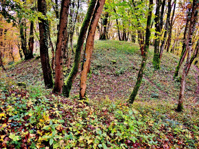
11e siècle Cette imposante structure, à fonction probablement résidentielle comme suggéré par le matériel découvert, s'apparente à des édifices de type « motte castrale ». On peut remarquer les composantes morphologiques de ces constructions, à savoir une motte, une basse-cour et des fossés, au nombre de trois. La motte, circulaire, domine la basse-cour. Les trois fossés constituent, à l'est, un imposant dispositif fermant le site du côté du plateau. Des prospections ont livré des tessons de céramique et un abondant mobilier métallique. Des monnaies apportent quelques éléments de chronologie, essentiellement pour les 15ème et 16ème siècles. La date d'édification de ce vaste ensemble fortifié, vraisemblablement dès le 11ème siècle, n'est pas établie en l'absence de travaux exhaustifs.
Map and restricted areas
Open in the main mapRestricted zones
| Zone | Category | Limits | Conditions |
|---|---|---|---|
| Zrt Hombory | ZRT | From the ground up to about 1,500 m above sea level | SUP AIP 038/26 · Du mardi 24 mars au jeudi 22 octobre 2026 |
| Mirage 2000 Ne | Zone réglementée | 1524 m above ground level → 3821 m above sea level | Vols interdits sauf lorsque the official document of the zone l'autorise explicitement ou avec l'accord du gestionnaire de la zone lorsqu'il est désigné par the official document of the zone |
Nearby aerodromes
Open aerodromes within 25 km of the spot, heliports included, with their distance and direction from the spot. Near an aerodrome, drone flying is prohibited or height-limited: check the UAS zones map.
| Aerodrome | Type | Distance | Elevation |
|---|---|---|---|
| Base ULM de Fontaine les Clerval | Aerodrome | 7.6 km W | 401 m |
| Montbéliard-Courcelles Airfield | Airport | 19 km NE | 317 m |
Aviation weather (METAR and TAF)
LFSM – Montbéliard-Courcelles Airfield MVFR
METAR
METAR LFSM 171230Z AUTO 23020G37KT 200V270 9999 OVC029 OVC035 16/11 Q0997
- Wind
- 230°, 37 km/h, gusts 69 km/h
- Visibility
- 10 km or more
- Clouds
- Overcast (8/8) at 2,900 ft (880 m) ; Overcast (8/8) at 3,500 ft (1070 m)
- Temperature
- 16 °C, dew point 11 °C
- QNH
- 997 hPa
- Flight category
- MVFR: ceiling 1,000–3,000 ft or visibility 3–5 mi
TAF
Weather and Kp index
| Day | Weather | Temp. min. / max. | Wind | Rain | Max Kp |
|---|---|---|---|---|---|
| Tue 17 Nov | Partly cloudy | 10° / 14° | 32 km/h SW | 3.6 mm | 5 |
| Wed 18 Nov | Heavy rain | 8° / 10° | 33 km/h SW | 12 mm | 5 |
| Thu 19 Nov | Showers | 7° / 10° | 31 km/h SW | 13 mm | 3 |
| Fri 20 Nov | Showers | 6° / 9° | 32 km/h SW | 14 mm | 3 |
| Sat 21 Nov | Showers | 7° / 8° | 25 km/h SW | 2.9 mm | – |
| Sun 22 Nov | Light rain | 4° / 7° | 22 km/h SW | 18 mm | – |
| Mon 23 Nov | Partly cloudy | 5° / 7° | 29 km/h SW | 10 mm | – |
Hour by hour: Tuesday 17 November
| Time | Weather | Temp. | Wind | Rain | Clouds | Kp |
|---|---|---|---|---|---|---|
| 14:00 | Partly cloudy | 14° | 32 km/h SW | – | 51 % | 4 |
| 15:00 | Partly cloudy | 14° | 32 km/h SW | – | 75 % | 4 |
| 16:00 | Partly cloudy | 14° | 29 km/h SW | – | 77 % | 4 |
| 17:00 | Partly cloudy | 14° | 27 km/h SW | – | 84 % | 4 |
| 18:00 | Partly cloudy | 13° | 26 km/h SW | – | 59 % | 4 |
| 19:00 | Partly cloudy | 13° | 27 km/h SW | – | 57 % | 5 |
| 20:00 | Partly cloudy | 13° | 32 km/h SW | – | 61 % | 5 |
| 21:00 | Cloudy | 12° | 30 km/h SW | – | 98 % | 5 |
| 22:00 | Heavy rain | 12° | 31 km/h SW | 1.8 mm | 100 % | 5 |
Hour by hour: Wednesday 18 November
| Time | Weather | Temp. | Wind | Rain | Clouds | Kp |
|---|---|---|---|---|---|---|
| 06:00 | Light rain | 9° | 28 km/h SW | 0.4 mm | 96 % | 4 |
| 07:00 | Fog | 8° | 27 km/h SW | – | 90 % | 4 |
| 08:00 | Showers | 9° | 26 km/h SW | 0.8 mm | 81 % | 4 |
| 09:00 | Light rain | 9° | 30 km/h SW | 0.4 mm | 99 % | 4 |
| 10:00 | Rain | 9° | 30 km/h SW | 0.9 mm | 100 % | 4 |
| 11:00 | Heavy rain | 9° | 31 km/h SW | 1.0 mm | 98 % | 4 |
| 12:00 | Showers | 9° | 32 km/h SW | 1.6 mm | 79 % | 4 |
| 13:00 | Heavy rain | 10° | 32 km/h SW | 1.3 mm | 93 % | 3 |
| 14:00 | Rain | 9° | 31 km/h SW | 0.7 mm | 91 % | 3 |
| 15:00 | Showers | 10° | 31 km/h SW | 1.0 mm | 30 % | 3 |
| 16:00 | Showers | 9° | 31 km/h SW | 0.2 mm | 65 % | 3 |
| 17:00 | Showers | 8° | 27 km/h SW | 0.7 mm | 65 % | 3 |
| 18:00 | Showers | 8° | 27 km/h SW | 0.5 mm | 55 % | 3 |
| 19:00 | Showers | 8° | 25 km/h SW | 0.4 mm | 63 % | 2 |
| 20:00 | Partly cloudy | 8° | 24 km/h SW | – | 51 % | 2 |
| 21:00 | Partly cloudy | 8° | 23 km/h SW | – | 62 % | 2 |
| 22:00 | Partly cloudy | 8° | 23 km/h SW | – | 64 % | 2 |
Sunrise and sunset
| Day | Dawn | Sunrise | Golden hour | Sunset | Dusk | Day length |
|---|---|---|---|---|---|---|
| Tue 17 Nov | 07:08 | 07:41 | 07:41–08:29 · 16:08–16:56 | 16:56 | 17:30 | 9 h 14 |
| Wed 18 Nov | 07:09 | 07:43 | 07:43–08:31 · 16:07–16:55 | 16:55 | 17:29 | 9 h 12 |
| Thu 19 Nov | 07:10 | 07:44 | 07:44–08:32 · 16:06–16:54 | 16:54 | 17:28 | 9 h 10 |
| Fri 20 Nov | 07:12 | 07:46 | 07:46–08:34 · 16:05–16:53 | 16:53 | 17:27 | 9 h 07 |
| Sat 21 Nov | 07:13 | 07:47 | 07:47–08:36 · 16:03–16:52 | 16:52 | 17:26 | 9 h 05 |
| Sun 22 Nov | 07:14 | 07:48 | 07:48–08:37 · 16:02–16:51 | 16:51 | 17:25 | 9 h 03 |
| Mon 23 Nov | 07:16 | 07:50 | 07:50–08:39 · 16:01–16:51 | 16:51 | 17:25 | 9 h 00 |
Reviews (0)
Log in to review this spot. Log in · Create a free account
No reviews yet. Share yours!