

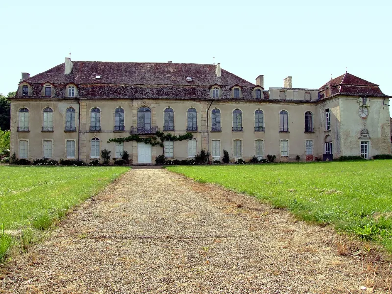
Montculot Castle
No reviews yet
Have you flown here? Share your experience with other pilots.
+ Write the first reviewHistory
18e siècle Château du 15e siècle, agrandi à partir de 1751. L'édifice est inachevé lorsque Louis-François de Lamartine l'acquiert en 1760. Il décore l'intérieur et aménage les jardins. Son neveu, Alphonse de Lamartine, y vient à partir de 1801 et en hérite en 1826, mais doit le vendre en 1831. Le château est formé d'un plan rectangulaire, à rez-de-chaussée, étage carré et combles couverts d'un toit à brisis et terrassons, flanqué d'une aile en retour d'équerre contenant l'ancienne chapelle. Les pièces sont ornées de boiseries et de cheminées en marbre 18e siècle.
Map and restricted areas
Open in the main mapRestricted zones
| Zone | Category | Limits | Conditions |
|---|---|---|---|
| R 124 | Zone réglementée | 3053 m above sea level → 6259 m above sea level | Vols interdits sauf lorsque the official document of the zone l'autorise explicitement ou avec l'accord du gestionnaire de la zone lorsqu'il est désigné par the official document of the zone |
| Zrt Pouilly | ZRT | From about 3,800 m to about 4,100 m above sea level | SUP AIP 053/26 · Du jeudi 16 avril 2026 au mercredi 12 avril 2028 |
| Zrt Pouilly High | ZRT | From about 5,650 m to about 5,950 m above sea level | SUP AIP 053/26 · Du jeudi 16 avril 2026 au mercredi 12 avril 2028 |
Nearby aerodromes
Open aerodromes within 25 km of the spot, heliports included, with their distance and direction from the spot. Near an aerodrome, drone flying is prohibited or height-limited: check the UAS zones map.
| Aerodrome | Type | Distance | Elevation |
|---|---|---|---|
| Centre Hospitalier Régional Heliport | Heliport | 15 km E | 238 m |
| Dijon Darois Airfield | Aerodrome | 15 km NE | 483 m |
| Aérodrome de Nuits-Saint-Georges | Aerodrome | 17 km SE | 243 m |
| Dijon-Bourgogne Airport | Airport | 19 km E | 221 m |
| Pouilly Maconge Airport | Aerodrome | 22 km W | 430 m |
Aviation weather (METAR and TAF)
LFSD – Dijon-Bourgogne Airport VFR
METAR
METAR LFSD 171400Z AUTO 21014KT 9999 FEW043 SCT066 17/10 Q0997
- Wind
- 210°, 26 km/h
- Visibility
- 10 km or more
- Clouds
- Few (1-2/8) at 4,300 ft (1310 m) ; Scattered (3-4/8) at 6,600 ft (2010 m)
- Temperature
- 17 °C, dew point 10 °C
- QNH
- 997 hPa
- Flight category
- VFR: ceiling > 3,000 ft and visibility > 5 mi
TAF
Weather and Kp index
Sunrise and sunset
| Day | Dawn | Sunrise | Golden hour | Sunset | Dusk | Day length |
|---|---|---|---|---|---|---|
| Tue 17 Nov | 07:14 | 07:48 | 07:48–08:35 · 16:16–17:03 | 17:03 | 17:37 | 9 h 15 |
| Wed 18 Nov | 07:16 | 07:49 | 07:49–08:37 · 16:14–17:02 | 17:02 | 17:36 | 9 h 13 |
| Thu 19 Nov | 07:17 | 07:51 | 07:51–08:39 · 16:13–17:01 | 17:01 | 17:35 | 9 h 10 |
| Fri 20 Nov | 07:18 | 07:52 | 07:52–08:40 · 16:12–17:01 | 17:01 | 17:34 | 9 h 08 |
| Sat 21 Nov | 07:20 | 07:53 | 07:53–08:42 · 16:11–17:00 | 17:00 | 17:33 | 9 h 06 |
| Sun 22 Nov | 07:21 | 07:55 | 07:55–08:44 · 16:10–16:59 | 16:59 | 17:33 | 9 h 03 |
| Mon 23 Nov | 07:22 | 07:56 | 07:56–08:45 · 16:09–16:58 | 16:58 | 17:32 | 9 h 01 |

Reviews (0)
Log in to review this spot. Log in · Create a free account
No reviews yet. Share yours!