

Montpoupon Castle
No reviews yet
Have you flown here? Share your experience with other pilots.
+ Write the first reviewHistory
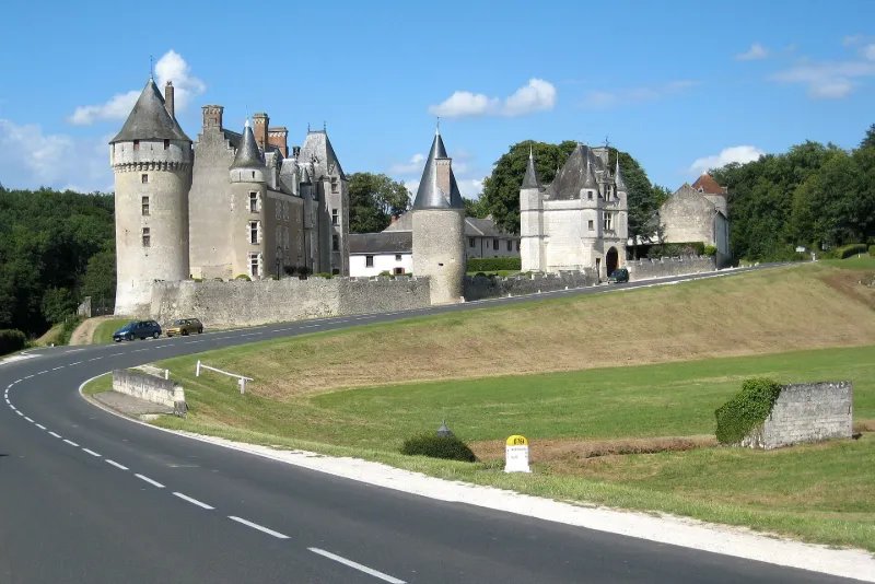
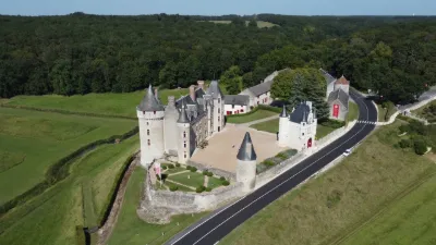
14e siècle ; 15e siècle ; 16e siècle La châtellenie relevait de Montrichard. Le châtelet date du 16e siècle et présente un aspect plus décoratif que défensif. Il se compose d'une tour carrée à deux étages, au-dessus-du porche voûté à double porte, flanquée vers l'extérieur de deux tourelles soutenues par des culs de lampe et éclairée de larges fenêtres à croisées de pierre, décorées de pilastres Renaissance. Du côté intérieur, une tour d'escalier octogonale donne accès aux étages. La tour d'angle de l'enceinte, cylindrique, est percée de meurtrières aux angles défensifs. Au 18e siècle, une corniche a pu remplacer les coyaux ou les mâchicoulis. Vers la cour d'honneur, un accrochement donne idée des murailles qui réunissaient cette tour au château et au châtelet. La tour ronde contigüe au château peut dater du 14e siècle et a été rebâtie. Elle est couronnée par un chemin de ronde datant du 15e siècle. Un escalier descend de cette courtine vers deux chambres carrées superposées avec cheminées en pierre gothiques. A l'étage inférieur se trouve une salle voûtée et, en-dessous, devait exister une sorte de cave ou salle basse défensive. Dans le château, le plafond de la salle-à-manger a été conservé malgré les remaniements du début du 20e siècle. Une peinture en camaïeu gris et noir sur des poutres brutes présente des motifs décoratifs de feuillages et d'arabesques pouvant dater de la fin du 16e siècle.
Map and restricted areas
Open in the main mapRestricted zones
Nearby aerodromes
Open aerodromes within 25 km of the spot, heliports included, with their distance and direction from the spot. Near an aerodrome, drone flying is prohibited or height-limited: check the UAS zones map.
| Aerodrome | Type | Distance | Elevation |
|---|---|---|---|
| Amboise Dierre Airport | Aerodrome | 18 km NW | 55 m |
Aviation weather (METAR and TAF)
LFOT – Tours-Val-de-Loire Airport VFR
METAR
METAR LFOT 171230Z AUTO 23016KT 9999 ////// 16/// Q0996
- Wind
- 230°, 30 km/h
- Visibility
- 10 km or more
- Clouds
- –
- Temperature
- –
- QNH
- 996 hPa
- Flight category
- VFR: ceiling > 3,000 ft and visibility > 5 mi
TAF
TAF LFOT 171100Z 1712/1812 25020G30KT 9999 BKN025 PROB40 TEMPO 1717/1721 25025G40KT 2500 SHRA BKN020CB PROB30 TEMPO 1718/1721 TS BECMG 1721/1723 24012KT PROB40 TEMPO 1804/1812 24020G30KT PROB30 TEMPO 1804/1810 3000 -TSRA BKN020CB
| Period (local time) | Change | Wind | Visibility | Weather | Clouds |
|---|---|---|---|---|---|
| 17/11 13:00 → 17/11 22:00 | Initial conditions | 250°, 37 km/h, gusts 56 km/h | 10 km or more | Broken (5-7/8) at 2,500 ft (760 m) | |
| 17/11 18:00 → 17/11 22:00 | Temporarily, probability 40% | 250°, 46 km/h, gusts 74 km/h | 2.5 km | Showers of rain | Broken (5-7/8) at 2,000 ft (610 m) (cumulonimbus) |
| 17/11 19:00 → 17/11 22:00 | Temporarily, probability 30% | Thunderstorm | |||
| 17/11 22:00 → 18/11 13:00 | Becoming | 240°, 22 km/h | 10 km or more | Broken (5-7/8) at 2,500 ft (760 m) | |
| 18/11 05:00 → 18/11 13:00 | Temporarily, probability 40% | 240°, 37 km/h, gusts 56 km/h | |||
| 18/11 05:00 → 18/11 11:00 | Temporarily, probability 30% | 3.0 km | Thunderstorm rain light | Broken (5-7/8) at 2,000 ft (610 m) (cumulonimbus) |
Weather and Kp index
| Day | Weather | Temp. min. / max. | Wind | Rain | Max Kp |
|---|---|---|---|---|---|
| Tue 17 Nov | Partly cloudy | 12° / 16° | 34 km/h SW | 2.8 mm | 5 |
| Wed 18 Nov | Fair | 10° / 15° | 32 km/h SW | 7.9 mm | 5 |
| Thu 19 Nov | Showers | 9° / 13° | 32 km/h SW | 4.9 mm | 3 |
| Fri 20 Nov | Light rain | 9° / 13° | 26 km/h SW | 1.3 mm | 3 |
| Sat 21 Nov | Cloudy | 7° / 11° | 19 km/h SW | 0.2 mm | – |
| Sun 22 Nov | Showers | 9° / 13° | 27 km/h SW | 11 mm | – |
| Mon 23 Nov | Clear sky | 6° / 12° | 18 km/h W | 0.4 mm | – |
Hour by hour: Tuesday 17 November
| Time | Weather | Temp. | Wind | Rain | Clouds | Kp |
|---|---|---|---|---|---|---|
| 15:00 | Partly cloudy | 16° | 30 km/h SW | – | 60 % | 4 |
| 16:00 | Partly cloudy | 16° | 30 km/h SW | – | 55 % | 4 |
| 17:00 | Light rain | 15° | 30 km/h SW | 0.3 mm | 89 % | 4 |
| 18:00 | Showers | 14° | 31 km/h SW | 0.3 mm | 67 % | 4 |
| 19:00 | Showers | 13° | 34 km/h SW | 0.9 mm | 85 % | 5 |
| 20:00 | Heavy rain | 12° | 32 km/h SW | 1.3 mm | 100 % | 5 |
| 21:00 | Cloudy | 12° | 32 km/h SW | – | 99 % | 5 |
| 22:00 | Cloudy | 12° | 28 km/h SW | – | 99 % | 5 |
Hour by hour: Wednesday 18 November
| Time | Weather | Temp. | Wind | Rain | Clouds | Kp |
|---|---|---|---|---|---|---|
| 06:00 | Partly cloudy | 10° | 23 km/h SW | – | 80 % | 4 |
| 07:00 | Partly cloudy | 10° | 24 km/h SW | – | 70 % | 4 |
| 08:00 | Partly cloudy | 10° | 24 km/h SW | – | 59 % | 4 |
| 09:00 | Partly cloudy | 10° | 24 km/h SW | – | 42 % | 4 |
| 10:00 | Partly cloudy | 12° | 27 km/h SW | – | 48 % | 4 |
| 11:00 | Fair | 13° | 28 km/h SW | – | 19 % | 4 |
| 12:00 | Showers | 14° | 32 km/h SW | 0.2 mm | 35 % | 4 |
| 13:00 | Fair | 14° | 29 km/h SW | – | 26 % | 3 |
| 14:00 | Showers | 15° | 28 km/h W | 0.1 mm | 43 % | 3 |
| 15:00 | Fair | 14° | 27 km/h SW | – | 22 % | 3 |
| 16:00 | Fair | 14° | 24 km/h SW | – | 30 % | 3 |
| 17:00 | Partly cloudy | 13° | 21 km/h SW | – | 58 % | 3 |
| 18:00 | Cloudy | 12° | 20 km/h SW | – | 99 % | 3 |
| 19:00 | Cloudy | 12° | 21 km/h SW | – | 100 % | 2 |
| 20:00 | Rain | 12° | 22 km/h S | 0.8 mm | 100 % | 2 |
| 21:00 | Heavy rain | 11° | 24 km/h S | 1.8 mm | 100 % | 2 |
| 22:00 | Heavy rain | 11° | 26 km/h S | 2.1 mm | 100 % | 2 |
Sunrise and sunset
| Day | Dawn | Sunrise | Golden hour | Sunset | Dusk | Day length |
|---|---|---|---|---|---|---|
| Tue 17 Nov | 07:29 | 08:02 | 08:02–08:50 · 16:31–17:18 | 17:18 | 17:52 | 9 h 15 |
| Wed 18 Nov | 07:30 | 08:04 | 08:04–08:52 · 16:29–17:17 | 17:17 | 17:51 | 9 h 13 |
| Thu 19 Nov | 07:32 | 08:05 | 08:05–08:53 · 16:28–17:16 | 17:16 | 17:50 | 9 h 11 |
| Fri 20 Nov | 07:33 | 08:07 | 08:07–08:55 · 16:27–17:15 | 17:15 | 17:49 | 9 h 08 |
| Sat 21 Nov | 07:34 | 08:08 | 08:08–08:57 · 16:26–17:14 | 17:14 | 17:48 | 9 h 06 |
| Sun 22 Nov | 07:36 | 08:10 | 08:10–08:58 · 16:25–17:14 | 17:14 | 17:47 | 9 h 04 |
| Mon 23 Nov | 07:37 | 08:11 | 08:11–09:00 · 16:24–17:13 | 17:13 | 17:47 | 9 h 01 |


Reviews (0)
Log in to review this spot. Log in · Create a free account
No reviews yet. Share yours!