

Former Val Richer Abbey
No reviews yet
Have you flown here? Share your experience with other pilots.
+ Write the first reviewHistory
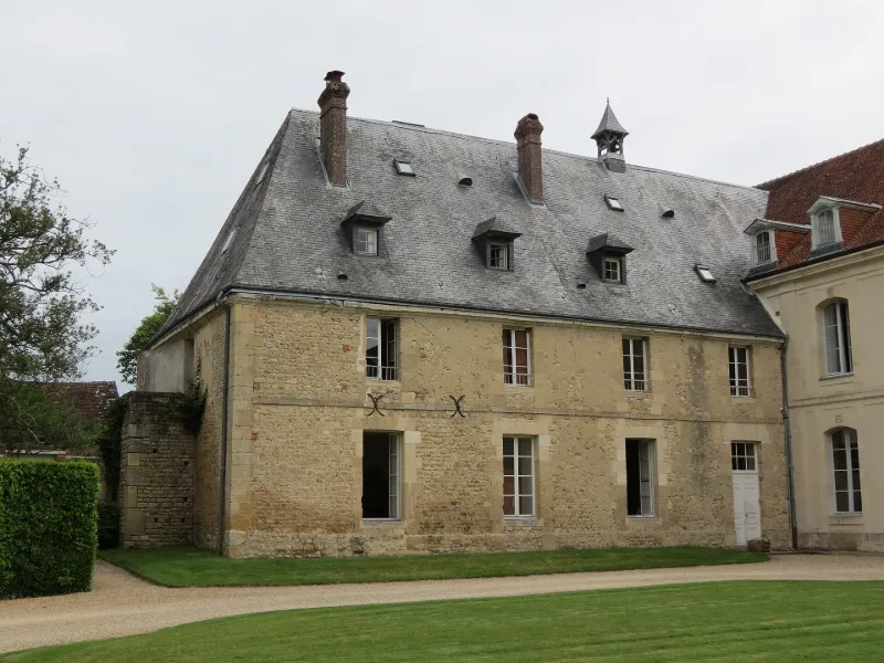
18e siècle ; 19e siècle ; 1er quart 20e siècle L'abbaye, fondée en 1167 par Philippe de Harcourt, évêque de Bayeux, fut l'un des rares établissements cisterciens de Normandie. Pillée en 1562 et 1589, l'abbaye déclina avant de connaître un renouveau au 17e siècle pour devenir l'un des hauts lieux de la Contre-Réforme. Au milieu du 18e siècle, les bâtiments furent reconstruits. A la Révolution, les bâtiments furent majoritairement détruits et le domaine démembré. Les bâtiments remontant à l'abbaye sont la "maison des hôtes" du 18e siècle, et le corps de ferme du 17e. L'ensemble a été réaménagé au 19e siècle pour y développer une activité culturelle. Au 20e siècle, le nouveau propriétaire, féru d'agronomie, y développa une activité agricole. Des bâtiments modernes ont alors été ajoutés aux parties anciennes. Résidence de François Guizot.
Map and restricted areas
Open in the main mapRestricted zones
Nearby aerodromes
Open aerodromes within 25 km of the spot, heliports included, with their distance and direction from the spot. Near an aerodrome, drone flying is prohibited or height-limited: check the UAS zones map.
| Aerodrome | Type | Distance | Elevation |
|---|---|---|---|
| Deauville-Saint-Gatien Airport | Airport | 23 km N | 146 m |
Aviation weather (METAR and TAF)
LFRG – Deauville-Saint-Gatien Airport MVFR
METAR
METAR LFRG 171400Z AUTO 22015G26KT 190V250 9999 BKN026/// OVC034/// OVC041/// ///TCU 14/11 Q0987 TEMPO 26020G42KT 1400 TSRAGS BKN008 BKN020CB
- Wind
- 220°, 28 km/h, gusts 48 km/h
- Visibility
- 10 km or more
- Clouds
- Broken (5-7/8) at 2,600 ft (790 m) ; Overcast (8/8) at 3,400 ft (1040 m) ; Overcast (8/8) at 4,100 ft (1250 m)
- Temperature
- 14 °C, dew point 11 °C
- QNH
- 987 hPa
- Flight category
- MVFR: ceiling 1,000–3,000 ft or visibility 3–5 mi
TAF
TAF LFRG 171400Z 1715/1724 26020G30KT 9999 BKN030 TEMPO 1715/1724 3000 SHRA BKN012 BKN020TCU SCT025CB TEMPO 1715/1718 26020G42KT PROB40 TEMPO 1715/1718 1400 TSRAGS BKN008 BKN020CB
| Period (local time) | Change | Wind | Visibility | Weather | Clouds |
|---|---|---|---|---|---|
| 17/11 16:00 → 18/11 01:00 | Initial conditions | 260°, 37 km/h, gusts 56 km/h | 10 km or more | Broken (5-7/8) at 3,000 ft (910 m) | |
| 17/11 16:00 → 18/11 01:00 | Temporarily | 3.0 km | Showers of rain | Broken (5-7/8) at 1,200 ft (370 m) ; Broken (5-7/8) at 2,000 ft (610 m) (towering cumulus) ; Scattered (3-4/8) at 2,500 ft (760 m) (cumulonimbus) | |
| 17/11 16:00 → 17/11 19:00 | Temporarily | 260°, 37 km/h, gusts 78 km/h | |||
| 17/11 16:00 → 17/11 19:00 | Temporarily, probability 40% | 1.4 km | Thunderstorm rain ; thunderstorm small hail | Broken (5-7/8) at 800 ft (240 m) ; Broken (5-7/8) at 2,000 ft (610 m) (cumulonimbus) |
Weather and Kp index
Sunrise and sunset
| Day | Dawn | Sunrise | Golden hour | Sunset | Dusk | Day length |
|---|---|---|---|---|---|---|
| Tue 17 Nov | 07:38 | 08:13 | 08:13–09:03 · 16:26–17:16 | 17:16 | 17:51 | 9 h 03 |
| Wed 18 Nov | 07:39 | 08:14 | 08:14–09:05 · 16:25–17:15 | 17:15 | 17:50 | 9 h 00 |
| Thu 19 Nov | 07:41 | 08:16 | 08:16–09:07 · 16:23–17:14 | 17:14 | 17:49 | 8 h 58 |
| Fri 20 Nov | 07:42 | 08:17 | 08:17–09:09 · 16:22–17:13 | 17:13 | 17:48 | 8 h 55 |
| Sat 21 Nov | 07:43 | 08:19 | 08:19–09:10 · 16:21–17:12 | 17:12 | 17:47 | 8 h 53 |
| Sun 22 Nov | 07:45 | 08:20 | 08:20–09:12 · 16:19–17:11 | 17:11 | 17:47 | 8 h 50 |
| Mon 23 Nov | 07:46 | 08:22 | 08:22–09:14 · 16:18–17:10 | 17:10 | 17:46 | 8 h 48 |

Reviews (0)
Log in to review this spot. Log in · Create a free account
No reviews yet. Share yours!