

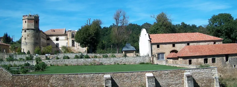
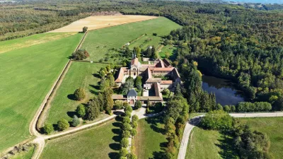
L'Arthaudière Castle
No reviews yet
Have you flown here? Share your experience with other pilots.
+ Write the first reviewHistory
16e siècle ; 17e siècle ; 18e siècle Le premier témoignage écrit de l'existence de la maison forte date de 1345. Construction d'une tour ronde au 13ème siècle, à laquelle vient s'ajouter une tour rectangulaire au début du 14ème. Construction de l'aile ouest au début du 16ème siècle. Le domaine est incendié en 1580 par les Huguenots. André II de La Porte entreprend la restauration du château vers 1590, dont le premier étage de l'aile nord. L'escalier monumental et le remaniement de l'aile est, datent de 1680. En 1726, des transformations sont apportées au château. A la fin du 19ème siècle, la tour ronde est surélevée par un volume polygonal en briques, couvert d'une terrasse. L'aile orientale reçoit un soubassement de calcaire blanc et les chaînes d'angle sont reprises. Dans les années 1950, un incendie détruit l'aile est.
Map and restricted areas
Open in the main mapRestricted zones
| Zone | Category | Limits | Conditions |
|---|---|---|---|
| Zrt Rone 3 Bravo | ZRT | From the ground up to about 2,000 m above sea level | SUP AIP 207/26 · Du lundi 28 septembre au vendredi 16 octobre 2026 |
Nearby aerodromes
Open aerodromes within 25 km of the spot, heliports included, with their distance and direction from the spot. Near an aerodrome, drone flying is prohibited or height-limited: check the UAS zones map.
| Aerodrome | Type | Distance | Elevation |
|---|---|---|---|
| Aérodrome de Romans - Saint-Paul | Aerodrome | 12 km SW | 181 m |
| Saint-Jean-en-Royans Airport | Aerodrome | 12 km SE | 264 m |
| Centre Hospitalier Heliport | Heliport | 19 km SW | 160 m |
Aviation weather (METAR and TAF)
LFLS – Grenoble-Isère Airport VFR
METAR
METAR LFLS 171330Z AUTO 22004KT 170V250 9999 BKN046 BKN060 OVC190 13/11 Q1003
- Wind
- 220°, 7 km/h
- Visibility
- 10 km or more
- Clouds
- Broken (5-7/8) at 4,600 ft (1400 m) ; Broken (5-7/8) at 6,000 ft (1830 m) ; Overcast (8/8) at 19,000 ft (5790 m)
- Temperature
- 13 °C, dew point 11 °C
- QNH
- 1003 hPa
- Flight category
- VFR: ceiling > 3,000 ft and visibility > 5 mi
TAF
TAF LFLS 170200Z 1703/1803 VRB05KT CAVOK PROB30 TEMPO 1703/1708 20012KT TEMPO 1708/1717 20012KT -RA BKN050 PROB40 TEMPO 1708/1717 20015G25KT 4000 RA BKN020 FM171700 20012KT CAVOK TEMPO 1717/1721 20015G25KT PROB40 TEMPO 1800/1803 VRB18G30KT 4000 SHRA BKN050TCU
| Period (local time) | Change | Wind | Visibility | Weather | Clouds |
|---|---|---|---|---|---|
| 17/11 04:00 → 17/11 18:00 | Initial conditions | Variable, 9 km/h | 10 km or more | No significant weather | No significant cloud |
| 17/11 04:00 → 17/11 09:00 | Temporarily, probability 30% | 200°, 22 km/h | |||
| 17/11 09:00 → 17/11 18:00 | Temporarily, probability 40% | 200°, 28 km/h, gusts 46 km/h | 4.0 km | Rain | Broken (5-7/8) at 2,000 ft (610 m) |
| 17/11 09:00 → 17/11 18:00 | Temporarily | 200°, 22 km/h | Rain light | Broken (5-7/8) at 5,000 ft (1520 m) | |
| 17/11 18:00 → 17/11 22:00 | Temporarily | 200°, 28 km/h, gusts 46 km/h | |||
| 17/11 18:00 → 18/11 04:00 | From | 200°, 22 km/h | 10 km or more | No significant weather | No significant cloud |
| 18/11 01:00 → 18/11 04:00 | Temporarily, probability 40% | Variable, 33 km/h, gusts 56 km/h | 4.0 km | Showers of rain | Broken (5-7/8) at 5,000 ft (1520 m) (towering cumulus) |
Weather and Kp index
| Day | Weather | Temp. min. / max. | Wind | Rain | Max Kp |
|---|---|---|---|---|---|
| Tue 17 Nov | Cloudy | 12° / 15° | 19 km/h SW | 2.7 mm | 5 |
| Wed 18 Nov | Fair | 10° / 16° | 19 km/h SW | 2.9 mm | 5 |
| Thu 19 Nov | Fair | 10° / 15° | 21 km/h SW | 7.3 mm | 3 |
| Fri 20 Nov | Showers | 8° / 13° | 15 km/h SW | 1.5 mm | 3 |
| Sat 21 Nov | Clear sky | 7° / 15° | 6 km/h N | 0.3 mm | – |
| Sun 22 Nov | Clear sky | 8° / 15° | 8 km/h SW | 12 mm | – |
| Mon 23 Nov | Partly cloudy | 6° / 12° | 6 km/h SW | 1.2 mm | – |
Hour by hour: Tuesday 17 November
| Time | Weather | Temp. | Wind | Rain | Clouds | Kp |
|---|---|---|---|---|---|---|
| 15:00 | Cloudy | 15° | 16 km/h SW | – | 100 % | 4 |
| 16:00 | Cloudy | 14° | 16 km/h S | – | 100 % | 4 |
| 17:00 | Light rain | 14° | 16 km/h SW | 0.2 mm | 100 % | 4 |
| 18:00 | Rain | 13° | 19 km/h SW | 0.4 mm | 100 % | 4 |
| 19:00 | Light rain | 12° | 19 km/h SW | 0.2 mm | 100 % | 5 |
| 20:00 | Heavy rain | 12° | 18 km/h SW | 1.4 mm | 100 % | 5 |
| 21:00 | Rain | 12° | 19 km/h S | 0.5 mm | 89 % | 5 |
| 22:00 | Partly cloudy | 12° | 17 km/h S | – | 46 % | 5 |
Hour by hour: Wednesday 18 November
| Time | Weather | Temp. | Wind | Rain | Clouds | Kp |
|---|---|---|---|---|---|---|
| 06:00 | Rain | 11° | 13 km/h W | 0.7 mm | 99 % | 4 |
| 07:00 | Light rain | 11° | 16 km/h N | 0.4 mm | 100 % | 4 |
| 08:00 | Showers | 11° | 19 km/h SW | 0.1 mm | 47 % | 4 |
| 09:00 | Clear sky | 12° | 18 km/h SW | – | 12 % | 4 |
| 10:00 | Clear sky | 14° | 16 km/h SW | – | 9 % | 4 |
| 11:00 | Fair | 15° | 16 km/h SW | – | 19 % | 4 |
| 12:00 | Fair | 16° | 17 km/h S | – | 14 % | 4 |
| 13:00 | Fair | 16° | 15 km/h S | – | 24 % | 3 |
| 14:00 | Showers | 16° | 14 km/h S | 0.1 mm | 63 % | 3 |
| 15:00 | Showers | 15° | 13 km/h S | 0.2 mm | 67 % | 3 |
| 16:00 | Showers | 14° | 12 km/h S | 0.3 mm | 79 % | 3 |
| 17:00 | Partly cloudy | 13° | 13 km/h SE | – | 76 % | 3 |
| 18:00 | Partly cloudy | 13° | 14 km/h S | – | 59 % | 3 |
| 19:00 | Partly cloudy | 12° | 14 km/h S | – | 85 % | 2 |
| 20:00 | Partly cloudy | 13° | 13 km/h S | – | 52 % | 2 |
| 21:00 | Fair | 11° | 13 km/h S | – | 34 % | 2 |
| 22:00 | Cloudy | 10° | 14 km/h S | – | 96 % | 2 |
Sunrise and sunset
| Day | Dawn | Sunrise | Golden hour | Sunset | Dusk | Day length |
|---|---|---|---|---|---|---|
| Tue 17 Nov | 07:08 | 07:40 | 07:40–08:25 · 16:23–17:08 | 17:08 | 17:40 | 9 h 28 |
| Wed 18 Nov | 07:09 | 07:41 | 07:41–08:26 · 16:22–17:07 | 17:07 | 17:39 | 9 h 26 |
| Thu 19 Nov | 07:10 | 07:42 | 07:42–08:28 · 16:21–17:06 | 17:06 | 17:39 | 9 h 24 |
| Fri 20 Nov | 07:12 | 07:44 | 07:44–08:29 · 16:20–17:06 | 17:06 | 17:38 | 9 h 21 |
| Sat 21 Nov | 07:13 | 07:45 | 07:45–08:31 · 16:19–17:05 | 17:05 | 17:37 | 9 h 19 |
| Sun 22 Nov | 07:14 | 07:46 | 07:46–08:32 · 16:18–17:04 | 17:04 | 17:36 | 9 h 17 |
| Mon 23 Nov | 07:15 | 07:48 | 07:48–08:34 · 16:17–17:03 | 17:03 | 17:36 | 9 h 15 |

Reviews (0)
Log in to review this spot. Log in · Create a free account
No reviews yet. Share yours!