

Bonnettes Hamlet
No reviews yet
Have you flown here? Share your experience with other pilots.
+ Write the first reviewHistory
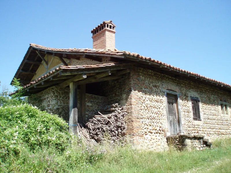
17e siècle Les bâtiments de la ferme "sud" figurés sur le cadastre de 1825 ont été remplacés au milieu du 19e siècle par une grange en pisé. Les deux bâtiments qui composent la ferme nord datent pour l'essentiel du 17e siècle. Bâtiments de plan à peu près carré, constitués d'une maçonnerie périphérique en galets supportant un étage en pan de bois garni de torchis. La maison d'habitation date de 1626 et la grange de 1643. Vers 1739, l'appentis ouest a été transformé en second logis, avec plafond à la française. Après 1825, le second appentis a été supprimé. Les bâtiments du hameau sont représentatifs de l'évolution des constructions rurales du Chambaran de la fin de l'époque moderne au début de l'époque contemporaine. La rareté des bâtiments en pan de bois et les caractéristiques de la ferme nord sont représentatifs des constructions rurales en pan de bois du 17e siècle dans ce secteur du Dauphiné.
Map and restricted areas
Open in the main mapRestricted zones
| Zone | Category | Limits | Conditions |
|---|---|---|---|
| Ctr Grenoble |
Zone de contrôle civile | 50 m above ground level → 1067 m above sea level | Flights above 50 metres are forbidden without the prior agreement of air traffic control |
Nearby aerodromes
Open aerodromes within 25 km of the spot, heliports included, with their distance and direction from the spot. Near an aerodrome, drone flying is prohibited or height-limited: check the UAS zones map.
| Aerodrome | Type | Distance | Elevation |
|---|---|---|---|
| Grenoble-Isère Airport | Airport | 11 km NE | 397 m |
Aviation weather (METAR and TAF)
LFLS – Grenoble-Isère Airport VFR
METAR
METAR LFLS 171400Z AUTO 02004KT 330V050 9999 BKN045 BKN054 BKN170 14/11 Q1003
- Wind
- 020°, 7 km/h
- Visibility
- 10 km or more
- Clouds
- Broken (5-7/8) at 4,500 ft (1370 m) ; Broken (5-7/8) at 5,400 ft (1650 m) ; Broken (5-7/8) at 17,000 ft (5180 m)
- Temperature
- 14 °C, dew point 11 °C
- QNH
- 1003 hPa
- Flight category
- VFR: ceiling > 3,000 ft and visibility > 5 mi
TAF
Weather and Kp index
| Day | Weather | Temp. min. / max. | Wind | Rain | Max Kp |
|---|---|---|---|---|---|
| Tue 17 Nov | Partly cloudy | 10° / 13° | 28 km/h SW | 0.4 mm | 5 |
| Wed 18 Nov | Partly cloudy | 9° / 14° | 26 km/h SW | 3.5 mm | 5 |
| Thu 19 Nov | Showers | 8° / 13° | 27 km/h S | 7.6 mm | 3 |
| Fri 20 Nov | Showers | 7° / 10° | 22 km/h SW | 3.4 mm | 3 |
| Sat 21 Nov | Clear sky | 7° / 13° | 16 km/h SW | – | – |
| Sun 22 Nov | Showers | 6° / 13° | 11 km/h SW | 12 mm | – |
| Mon 23 Nov | Partly cloudy | 5° / 10° | 14 km/h SW | – | – |
Hour by hour: Tuesday 17 November
| Time | Weather | Temp. | Wind | Rain | Clouds | Kp |
|---|---|---|---|---|---|---|
| 15:00 | Partly cloudy | 13° | 22 km/h S | – | 83 % | 4 |
| 16:00 | Cloudy | 13° | 22 km/h S | – | 100 % | 4 |
| 17:00 | Cloudy | 12° | 21 km/h SW | – | 99 % | 4 |
| 18:00 | Light rain | 12° | 26 km/h SW | 0.2 mm | 100 % | 4 |
| 19:00 | Cloudy | 11° | 28 km/h SW | – | 95 % | 5 |
| 20:00 | Light rain | 11° | 26 km/h SW | 0.2 mm | 99 % | 5 |
| 21:00 | Partly cloudy | 11° | 27 km/h S | – | 65 % | 5 |
| 22:00 | Partly cloudy | 11° | 26 km/h SW | – | 57 % | 5 |
Hour by hour: Wednesday 18 November
| Time | Weather | Temp. | Wind | Rain | Clouds | Kp |
|---|---|---|---|---|---|---|
| 06:00 | Showers | 10° | 21 km/h SW | 0.3 mm | 78 % | 4 |
| 07:00 | Showers | 9° | 19 km/h S | 0.7 mm | 73 % | 4 |
| 08:00 | Showers | 9° | 17 km/h S | 1.3 mm | 70 % | 4 |
| 09:00 | Fair | 10° | 18 km/h SW | – | 31 % | 4 |
| 10:00 | Showers | 11° | 19 km/h S | 0.1 mm | 16 % | 4 |
| 11:00 | Showers | 12° | 20 km/h S | 0.2 mm | 38 % | 4 |
| 12:00 | Partly cloudy | 13° | 18 km/h S | – | 61 % | 4 |
| 13:00 | Partly cloudy | 14° | 17 km/h S | – | 56 % | 3 |
| 14:00 | Partly cloudy | 14° | 16 km/h S | – | 75 % | 3 |
| 15:00 | Partly cloudy | 14° | 15 km/h S | – | 58 % | 3 |
| 16:00 | Cloudy | 12° | 17 km/h S | – | 88 % | 3 |
| 17:00 | Partly cloudy | 11° | 15 km/h S | – | 76 % | 3 |
| 18:00 | Cloudy | 11° | 14 km/h S | – | 98 % | 3 |
| 19:00 | Partly cloudy | 12° | 17 km/h S | – | 86 % | 2 |
| 20:00 | Partly cloudy | 12° | 17 km/h S | – | 60 % | 2 |
| 21:00 | Partly cloudy | 11° | 18 km/h SW | – | 58 % | 2 |
| 22:00 | Partly cloudy | 11° | 19 km/h S | – | 84 % | 2 |
Sunrise and sunset
| Day | Dawn | Sunrise | Golden hour | Sunset | Dusk | Day length |
|---|---|---|---|---|---|---|
| Tue 17 Nov | 07:08 | 07:40 | 07:40–08:26 · 16:22–17:08 | 17:08 | 17:40 | 9 h 27 |
| Wed 18 Nov | 07:10 | 07:42 | 07:42–08:27 · 16:21–17:07 | 17:07 | 17:39 | 9 h 25 |
| Thu 19 Nov | 07:11 | 07:43 | 07:43–08:29 · 16:20–17:06 | 17:06 | 17:38 | 9 h 23 |
| Fri 20 Nov | 07:12 | 07:44 | 07:44–08:30 · 16:19–17:05 | 17:05 | 17:37 | 9 h 20 |
| Sat 21 Nov | 07:13 | 07:46 | 07:46–08:32 · 16:18–17:04 | 17:04 | 17:37 | 9 h 18 |
| Sun 22 Nov | 07:14 | 07:47 | 07:47–08:33 · 16:17–17:04 | 17:04 | 17:36 | 9 h 16 |
| Mon 23 Nov | 07:16 | 07:48 | 07:48–08:35 · 16:16–17:03 | 17:03 | 17:35 | 9 h 14 |

Reviews (0)
Log in to review this spot. Log in · Create a free account
No reviews yet. Share yours!