

Montalegre Castle
No reviews yet
Have you flown here? Share your experience with other pilots.
+ Write the first reviewHistory
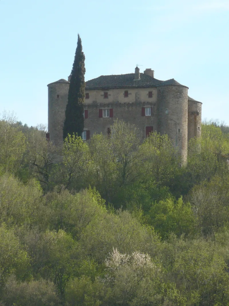
14e siècle La seigneurie de Montalègre est connue depuis 1268. Au 15e siècle, elle appartenait à la maison de Rodez, et passa ensuite entre les mains de différents représentants de la noblesse rouergate et limousine. De plan féodal, le château se compose d'un corps de logis presque carré, flanqué de quatre tours rondes. La façade sud comporte une saillie traduisant la présence de l'escalier à vis central. A chaque étage, une porte donne accès à une petite pièce dans chacune des tours. Le deuxième étage conserve trois cheminées gothiques et une porte moulurée. Le troisième et dernier étage, autrefois consacré à la défense (les mâchicoulis ont disparu) , a été transformé en grenier. Dans la tour nord-est est conservée une pièce voûtée en cul-de-four portant des traces de peinture à motifs religieux, semblant être une ancienne chapelle. Ces traces correspondent avec la présence, au premier étage, d'une chapelle à décor 19e siècle.
Map and restricted areas
Open in the main mapRestricted zones
| Zone | Category | Limits | Conditions |
|---|---|---|---|
| Zrt Victor | ZRT | From the ground up to about 2,000 m above sea level | SUP AIP 219/26 · Du mardi 20 octobre au jeudi 22 octobre 2026 |
| Tarn | Zone réglementée | 244 m above ground level → 1280 m above sea level | Vols interdits sauf lorsque the official document of the zone l'autorise explicitement ou avec l'accord du gestionnaire de la zone lorsqu'il est désigné par the official document of the zone |
| Istres | Zone réglementée | 5491 m above sea level → 30766 m above sea level | Vols interdits sauf lorsque the official document of the zone l'autorise explicitement ou avec l'accord du gestionnaire de la zone lorsqu'il est désigné par the official document of the zone |
| Istres | Zone réglementée | 5491 m above sea level → 30766 m above sea level | Vols interdits sauf lorsque the official document of the zone l'autorise explicitement ou avec l'accord du gestionnaire de la zone lorsqu'il est désigné par the official document of the zone |
| Istres | Zone réglementée | 5491 m above sea level → 30766 m above sea level | Vols interdits sauf lorsque the official document of the zone l'autorise explicitement ou avec l'accord du gestionnaire de la zone lorsqu'il est désigné par the official document of the zone |
| Istres | Zone réglementée | 5491 m above sea level → 30766 m above sea level | Vols interdits sauf lorsque the official document of the zone l'autorise explicitement ou avec l'accord du gestionnaire de la zone lorsqu'il est désigné par the official document of the zone |
| Zrt Belmont - Tarn | ZRT | 800 ft ASFC / 4200 ft AMSL | SUP AIP 216/26 · Du mercredi 14 octobre au jeudi 22 octobre 2026 |
Nearby aerodromes
Open aerodromes within 25 km of the spot, heliports included, with their distance and direction from the spot. Near an aerodrome, drone flying is prohibited or height-limited: check the UAS zones map.
| Aerodrome | Type | Distance | Elevation |
|---|---|---|---|
| Saint-Affrique-Belmont Airport | Aerodrome | 17 km SW | 514 m |
| Millau-Larzac Airfield | Aerodrome | 23 km NE | 794 m |
Aviation weather (METAR and TAF)
No METAR station within 50 km.
Weather and Kp index
| Day | Weather | Temp. min. / max. | Wind | Rain | Max Kp |
|---|---|---|---|---|---|
| Tue 17 Nov | Rain | 10° / 13° | 16 km/h W | 6.5 mm | 5 |
| Wed 18 Nov | Partly cloudy | 8° / 14° | 24 km/h W | 3.1 mm | 5 |
| Thu 19 Nov | Showers | 7° / 12° | 38 km/h W | 17 mm | 3 |
| Fri 20 Nov | Light rain | 7° / 11° | 28 km/h W | 3.1 mm | 3 |
| Sat 21 Nov | Partly cloudy | 7° / 13° | 13 km/h E | – | – |
| Sun 22 Nov | Showers | 8° / 11° | 25 km/h W | 5.0 mm | – |
| Mon 23 Nov | Partly cloudy | 6° / 10° | 19 km/h W | 0.2 mm | – |
Hour by hour: Tuesday 17 November
| Time | Weather | Temp. | Wind | Rain | Clouds | Kp |
|---|---|---|---|---|---|---|
| 15:00 | Rain | 13° | 16 km/h W | 0.9 mm | 100 % | 4 |
| 16:00 | Rain | 12° | 14 km/h W | 0.5 mm | 100 % | 4 |
| 17:00 | Light rain | 12° | 13 km/h W | 0.3 mm | 99 % | 4 |
| 18:00 | Rain | 11° | 9 km/h SW | 0.5 mm | 97 % | 4 |
| 19:00 | Heavy rain | 10° | 7 km/h SW | 1.1 mm | 100 % | 5 |
| 20:00 | Heavy rain | 10° | 6 km/h SW | 1.0 mm | 100 % | 5 |
| 21:00 | Heavy rain | 10° | 8 km/h S | 1.2 mm | 100 % | 5 |
| 22:00 | Rain | 10° | 10 km/h S | 0.7 mm | 100 % | 5 |
Hour by hour: Wednesday 18 November
| Time | Weather | Temp. | Wind | Rain | Clouds | Kp |
|---|---|---|---|---|---|---|
| 06:00 | Light rain | 12° | 21 km/h W | 0.3 mm | 100 % | 4 |
| 07:00 | Cloudy | 11° | 21 km/h W | – | 99 % | 4 |
| 08:00 | Cloudy | 11° | 23 km/h W | – | 100 % | 4 |
| 09:00 | Cloudy | 11° | 23 km/h W | – | 100 % | 4 |
| 10:00 | Light rain | 11° | 24 km/h W | 0.1 mm | 94 % | 4 |
| 11:00 | Cloudy | 12° | 23 km/h W | – | 91 % | 4 |
| 12:00 | Partly cloudy | 12° | 22 km/h W | – | 53 % | 4 |
| 13:00 | Partly cloudy | 13° | 24 km/h W | – | 66 % | 3 |
| 14:00 | Fair | 13° | 23 km/h W | – | 27 % | 3 |
| 15:00 | Partly cloudy | 14° | 24 km/h W | – | 66 % | 3 |
| 16:00 | Fair | 13° | 22 km/h W | – | 17 % | 3 |
| 17:00 | Fair | 12° | 17 km/h W | – | 38 % | 3 |
| 18:00 | Partly cloudy | 10° | 14 km/h W | – | 86 % | 3 |
| 19:00 | Partly cloudy | 9° | 8 km/h SW | – | 91 % | 2 |
| 20:00 | Partly cloudy | 9° | 6 km/h SE | – | 68 % | 2 |
| 21:00 | Partly cloudy | 8° | 11 km/h SE | – | 99 % | 2 |
| 22:00 | Cloudy | 9° | 18 km/h SE | – | 99 % | 2 |
Sunrise and sunset
| Day | Dawn | Sunrise | Golden hour | Sunset | Dusk | Day length |
|---|---|---|---|---|---|---|
| Tue 17 Nov | 07:14 | 07:46 | 07:46–08:29 · 16:37–17:21 | 17:21 | 17:52 | 9 h 35 |
| Wed 18 Nov | 07:16 | 07:47 | 07:47–08:31 · 16:36–17:20 | 17:20 | 17:51 | 9 h 33 |
| Thu 19 Nov | 07:17 | 07:48 | 07:48–08:32 · 16:35–17:19 | 17:19 | 17:50 | 9 h 31 |
| Fri 20 Nov | 07:18 | 07:49 | 07:49–08:34 · 16:34–17:18 | 17:18 | 17:50 | 9 h 29 |
| Sat 21 Nov | 07:19 | 07:51 | 07:51–08:35 · 16:33–17:18 | 17:18 | 17:49 | 9 h 26 |
| Sun 22 Nov | 07:20 | 07:52 | 07:52–08:37 · 16:32–17:17 | 17:17 | 17:48 | 9 h 25 |
| Mon 23 Nov | 07:22 | 07:53 | 07:53–08:38 · 16:31–17:16 | 17:16 | 17:48 | 9 h 23 |

Reviews (0)
Log in to review this spot. Log in · Create a free account
No reviews yet. Share yours!