

Pouthet Castle
No reviews yet
Have you flown here? Share your experience with other pilots.
+ Write the first reviewHistory
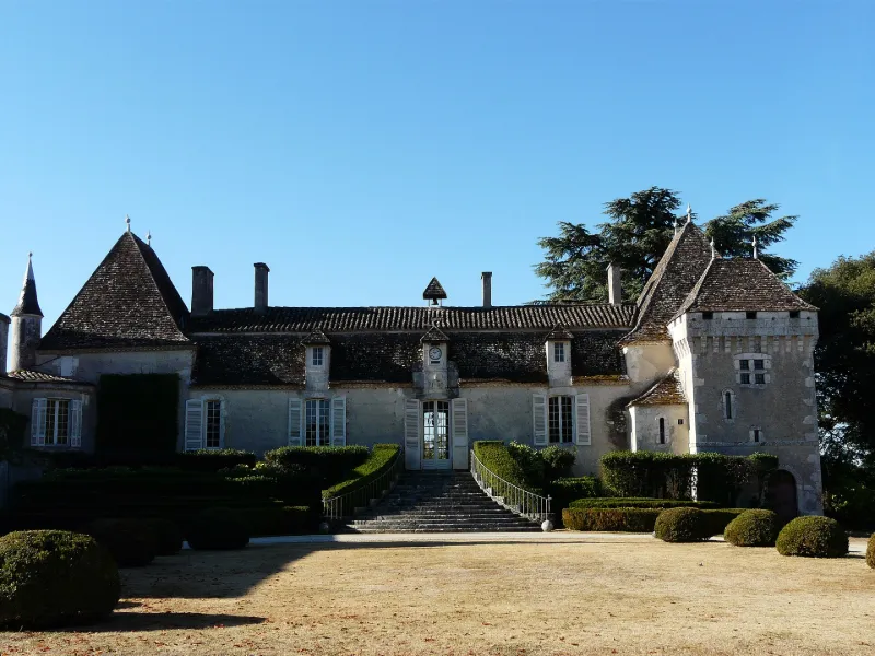
18e siècle ; 19e siècle Edifice formant un L avec l'ancienne aile des communs, à l'est. Le corps central rectangulaire est encadré de deux tours carrées. Un escalier convexe permet l'accès au rez-de-chaussée surélevé, et représente le seul ornement de la façade. Dans les années 1860, pour répondre aux activités viticole et agricole, des chais sont construits au nord. Dans les années 1890, les dépendances sont reconstruites au nord-ouest, une tour à faux mâchicoulis est accolée à la tour ouest, et une tourelle est édifiée dans l'angle est. Un parc paysager et un potager polychrome complètent les aménagements du 19e siècle.
Map and restricted areas
Open in the main mapRestricted zones
| Zone | Category | Limits | Conditions |
|---|---|---|---|
| Sebah Eh 01.067 A | Entrainement Militaire | 0 m above ground level → 9145 m above ground level | Pilotage de drones en vue directe : les aéronefs dont la masse est supérieure à 900 grammes sont soumis à notification préalable selon des modalités publiées sur le site www.ecologie.gouv.fr |
| Zena Perigord Low | ZRT | FL 165 / FL 195 | SUP AIP 062/26 · Du jeudi 23 avril 2026 au jeudi 25 mars 2027 |
| Zena Perigord Medium | ZRT | FL 195 / FL 245 | SUP AIP 062/26 · Du jeudi 23 avril 2026 au jeudi 25 mars 2027 |
| Zena Perigord High | ZRT | FL 395 / UNL | SUP AIP 062/26 · Du jeudi 23 avril 2026 au jeudi 25 mars 2027 |
Nearby aerodromes
Open aerodromes within 25 km of the spot, heliports included, with their distance and direction from the spot. Near an aerodrome, drone flying is prohibited or height-limited: check the UAS zones map.
| Aerodrome | Type | Distance | Elevation |
|---|---|---|---|
| Bergerac-Roumanière Airport | Airport | 18 km NE | 52 m |
Aviation weather (METAR and TAF)
LFBE – Bergerac-Roumanière Airport VFR
METAR
METAR LFBE 171330Z AUTO 20006KT 160V230 9999 FEW035 OVC100 17/14 Q1002 TEMPO 24015G25KT 4000 SHRA BKN020TCU
- Wind
- 200°, 11 km/h
- Visibility
- 10 km or more
- Clouds
- Few (1-2/8) at 3,500 ft (1070 m) ; Overcast (8/8) at 10,000 ft (3050 m)
- Temperature
- 17 °C, dew point 14 °C
- QNH
- 1002 hPa
- Flight category
- VFR: ceiling > 3,000 ft and visibility > 5 mi
TAF
TAF LFBE 171100Z 1712/1812 24010KT 9999 BKN020 TEMPO 1712/1714 24015G25KT 3000 RA OVC010 PROB30 TEMPO 1714/1720 24015G25KT 4000 SHRA BKN020TCU TEMPO 1720/1812 24015G25KT 3500 SHRA BKN010 BKN040TCU PROB30 TEMPO 1722/1802 24020G35KT 2000 TSRA BKN008 BKN020CB
| Period (local time) | Change | Wind | Visibility | Weather | Clouds |
|---|---|---|---|---|---|
| 17/11 13:00 → 18/11 13:00 | Initial conditions | 240°, 19 km/h | 10 km or more | Broken (5-7/8) at 2,000 ft (610 m) | |
| 17/11 13:00 → 17/11 15:00 | Temporarily | 240°, 28 km/h, gusts 46 km/h | 3.0 km | Rain | Overcast (8/8) at 1,000 ft (300 m) |
| 17/11 15:00 → 17/11 21:00 | Temporarily, probability 30% | 240°, 28 km/h, gusts 46 km/h | 4.0 km | Showers of rain | Broken (5-7/8) at 2,000 ft (610 m) (towering cumulus) |
| 17/11 21:00 → 18/11 13:00 | Temporarily | 240°, 28 km/h, gusts 46 km/h | 3.5 km | Showers of rain | Broken (5-7/8) at 1,000 ft (300 m) ; Broken (5-7/8) at 4,000 ft (1220 m) (towering cumulus) |
| 17/11 23:00 → 18/11 03:00 | Temporarily, probability 30% | 240°, 37 km/h, gusts 65 km/h | 2.0 km | Thunderstorm rain | Broken (5-7/8) at 800 ft (240 m) ; Broken (5-7/8) at 2,000 ft (610 m) (cumulonimbus) |
Weather and Kp index
| Day | Weather | Temp. min. / max. | Wind | Rain | Max Kp |
|---|---|---|---|---|---|
| Tue 17 Nov | Heavy rain | 14° / 15° | 25 km/h W | 11 mm | 5 |
| Wed 18 Nov | Partly cloudy | 12° / 16° | 27 km/h W | 10 mm | 5 |
| Thu 19 Nov | Rain | 10° / 13° | 32 km/h W | 17 mm | 3 |
| Fri 20 Nov | Rain | 10° / 14° | 25 km/h SW | 11 mm | 3 |
| Sat 21 Nov | Cloudy | 8° / 14° | 15 km/h E | 4.5 mm | – |
| Sun 22 Nov | Fair | 11° / 14° | 24 km/h W | 2.7 mm | – |
| Mon 23 Nov | Cloudy | 8° / 14° | 12 km/h SW | – | – |
Hour by hour: Tuesday 17 November
| Time | Weather | Temp. | Wind | Rain | Clouds | Kp |
|---|---|---|---|---|---|---|
| 15:00 | Heavy rain | 15° | 21 km/h SW | 5.6 mm | 100 % | 4 |
| 16:00 | Heavy rain | 14° | 17 km/h SW | 4.4 mm | 100 % | 4 |
| 17:00 | Heavy rain | 14° | 15 km/h SW | 1.1 mm | 99 % | 4 |
| 18:00 | Cloudy | 14° | 20 km/h SW | – | 94 % | 4 |
| 19:00 | Cloudy | 14° | 21 km/h SW | – | 96 % | 5 |
| 20:00 | Cloudy | 14° | 24 km/h SW | – | 98 % | 5 |
| 21:00 | Light rain | 14° | 23 km/h SW | 0.1 mm | 100 % | 5 |
| 22:00 | Light rain | 15° | 25 km/h W | 0.2 mm | 100 % | 5 |
Hour by hour: Wednesday 18 November
| Time | Weather | Temp. | Wind | Rain | Clouds | Kp |
|---|---|---|---|---|---|---|
| 06:00 | Fair | 13° | 21 km/h W | – | 20 % | 4 |
| 07:00 | Clear sky | 13° | 22 km/h W | – | 12 % | 4 |
| 08:00 | Fair | 12° | 20 km/h W | – | 13 % | 4 |
| 09:00 | Fair | 13° | 20 km/h SW | – | 16 % | 4 |
| 10:00 | Partly cloudy | 14° | 21 km/h W | – | 40 % | 4 |
| 11:00 | Showers | 15° | 24 km/h W | 1.2 mm | 71 % | 4 |
| 12:00 | Fair | 13° | 22 km/h SW | – | 37 % | 4 |
| 13:00 | Partly cloudy | 15° | 27 km/h W | – | 61 % | 3 |
| 14:00 | Fair | 16° | 21 km/h SW | – | 20 % | 3 |
| 15:00 | Fair | 16° | 23 km/h W | – | 27 % | 3 |
| 16:00 | Partly cloudy | 16° | 21 km/h W | – | 39 % | 3 |
| 17:00 | Clear sky | 15° | 15 km/h SW | – | 10 % | 3 |
| 18:00 | Partly cloudy | 13° | 12 km/h SW | – | 54 % | 3 |
| 19:00 | Cloudy | 12° | 10 km/h S | – | 100 % | 2 |
| 20:00 | Cloudy | 13° | 15 km/h SE | – | 100 % | 2 |
| 21:00 | Rain | 13° | 20 km/h SE | 0.4 mm | 100 % | 2 |
| 22:00 | Heavy rain | 13° | 21 km/h SE | 2.5 mm | 100 % | 2 |
Sunrise and sunset
| Day | Dawn | Sunrise | Golden hour | Sunset | Dusk | Day length |
|---|---|---|---|---|---|---|
| Tue 17 Nov | 07:26 | 07:58 | 07:58–08:43 · 16:44–17:29 | 17:29 | 18:00 | 9 h 31 |
| Wed 18 Nov | 07:27 | 07:59 | 07:59–08:44 · 16:43–17:28 | 17:28 | 18:00 | 9 h 28 |
| Thu 19 Nov | 07:29 | 08:00 | 08:00–08:45 · 16:42–17:27 | 17:27 | 17:59 | 9 h 26 |
| Fri 20 Nov | 07:30 | 08:02 | 08:02–08:47 · 16:41–17:26 | 17:26 | 17:58 | 9 h 24 |
| Sat 21 Nov | 07:31 | 08:03 | 08:03–08:48 · 16:40–17:25 | 17:25 | 17:57 | 9 h 22 |
| Sun 22 Nov | 07:32 | 08:04 | 08:04–08:50 · 16:39–17:25 | 17:25 | 17:57 | 9 h 20 |
| Mon 23 Nov | 07:33 | 08:06 | 08:06–08:51 · 16:38–17:24 | 17:24 | 17:56 | 9 h 18 |

Reviews (0)
Log in to review this spot. Log in · Create a free account
No reviews yet. Share yours!